Kathleen Lowery – Benton

Mrs. Kathleen (Collins) Lowery passed away peacefully on November 3, 2017 at Helia Healthcare Center in Benton at the age of 86.

Mrs. Lowery was born in Benton on December 12, 1930, the daughter of Clyde and Ethel Collins, who owned and operated several local restaurants in Benton. She attended Benton Township High School, where she was Homecoming Queen and named Miss Benton. She married Warren Mitchell in 1948, and was widowed in 1951 as a result of the Orient No. 2 Mine Disaster.

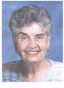
In 1953, she married Clarence “Red” Lowery and together they shared over 61 years of marriage together. Mrs. Lowery was part of the first graduating class of Rend Lake College in Ina, and she then attended Southern Illinois University-Carbondale, where she earned her bachelor’s degree and master’s studies.

For nearly two decades, Mrs. Lowery was an educator at Benton Consolidated High School, where she taught English, reading, and literature. During her time, Mrs. Lowery was known as dedicated, caring and fun teacher who took interest in each student she met. Whether it was teaching one of the literature classics or participating in homecoming skits, she was always enthusiastic and a good sport. She helped many students succeed in school and earn their diploma, despite their background, economic struggles, or situation in life that may have prevented them. She found personal success in her student’s achievements and stayed connected with many throughout her life.

Mrs. Lowery was an active member of the Benton community. She was a member of the Illinois Education Association, and previously served on the executive board of the Franklin County Retired Teachers Association, making yearly trips to the state capitol to meet with legislators and advocate for issues for retired educators. She was also a past president of the American Association of University Women in Benton.

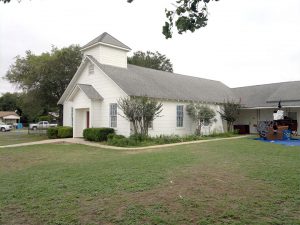
As a longtime member of the First Baptist Church, she served as a deacon and member of the church choir. She was also a member of the Lucy Helm Mission Circle, where she volunteered her time in service of others, whether it was delivering meals to those who were homebound, gathering supplies for families in need, or teaching Sunday school.

Together with her husband, Mrs. Lowery traveled all over the world, including to her favorite places of Spain, Mexico, the Bahamas and making frequent trips to Florida to visit her children and grandchildren. She was a gifted artist, whose paintings and drawings now hang in her family’s homes, and a talented writer, known for writing witty poems for faculty retirements and special occasions.

She also enjoyed boating on Rend Lake, tending to her garden and flowers, and caring for the many pets and animals that resided at her home over the past 40 years, including her most beloved dog, Rusty.

Above all else, Mrs. Lowery took pride in her family and loved spending time with them, along with her many friends. She will be remembered as someone who brought warmth, generosity, and kindness to all those around her.

She is survived by her children; Lynn Alligood and husband Bob, of Jacksonville Beach, Florida, Cindy Lowery of Jacksonville Beach, Florida, Robert Lowery and wife Lisa, of Benton, grandchildren; Kathleen Wubker and husband Brian, of Virginia Beach, Virginia, Olivia Lowery of Sister Bay, Wisconsin, Christopher Lowery of Springfield, Clarence Wade Lowery of Jacksonville, Florida, Ryan Lowery of Benton, and Mackenzie Lowery of Neptune Beach, Florida, great-grandchildren; Lillian Kathleen Warpinski, Sophia Wubker, Bennett Wubker, Oliver Reichel, and Christian Reichel, nephew; Bill Lowery of Benton, sister; Kay Cheek of Pinckneyville; and many nieces and nephews.

She was preceded in death by her husbands; parents; sister; Ramona Hill, and son; Clarence Clyde “C.C.” Lowery.

Funeral services will be held at 11:00 a.m. Saturday, November 11, 2017 at the First Baptist Church of Benton, with Rev. Alan Newman and Rev. Jim Jenkel officiating. Burial will be in the Knob Prairie Cemetery near Akin.  Visitation will be from 10:00 a.m. until the funeral hour, at the church.

Arrangements are with the Leffler Funeral Home of Benton.

In lieu of flowers, memorials may be made to the Benton/West City Ministerial Alliance or the American Humane Society, and will be accepted at the Leffler Funeral Home of Benton.

To leave online condolences to the family, or to share memories of Kathleen, visit www.lpfuneralhome.com


More rain on the way this evening

A pair of upper-level disturbances will bring precipitation to the region through Tuesday night. The first will bring showers and a few thunderstorms eastward across the region from late this afternoon through early Tuesday. The second will bring mainly light rain to the region Tuesday night. The sun will return Wednesday. In the meantime, clouds, rainfall and north winds will combine to make it feel quite cool, with high temperatures well below normal (NWS Paducah)

Hazardous Weather Outlook


This Hazardous Weather Outlook is for portions of southern
Illinois, southwest Indiana, western Kentucky, and southeast
Missouri.

.DAY ONE…Today and Tonight

Thunderstorms are possible this afternoon into this evening across
southeast Missouri, and portions of southern Illinois and west
Kentucky south of a line from Du Quoin Illinois, to Shawneetown,
to Calhoun Kentucky. Small hail will be possible with
thunderstorms, and a few thunderstorms may produce quarter size
hail or larger. Brief heavy rainfall and lightning will also be a
concern.

.DAYS TWO THROUGH SEVEN…Tuesday through Sunday

No hazardous weather is expected at this time.

.SPOTTER INFORMATION STATEMENT…

Spotter reports of hail or any other damage would be greatly
appreciated this afternoon and this evening.

Seven Day Forecast


This Afternoon
A 40 percent chance of showers, mainly after 5pm. Cloudy, with a high near 53. Northeast wind around 8 mph.
Tonight
Showers likely, mainly between 7pm and 2am. Cloudy, with a low around 45. Northeast wind around 7 mph. Chance of precipitation is 70%.
Tuesday
A chance of showers before noon, then a slight chance of rain after noon. Cloudy, with a high near 53. North wind around 8 mph. Chance of precipitation is 30%.
Tuesday Night
A 40 percent chance of rain, mainly before midnight. Cloudy, with a low around 39. North northeast wind around 7 mph.
Wednesday
Mostly sunny, with a high near 52. North northeast wind 6 to 8 mph.
Wednesday Night
Partly cloudy, with a low around 35. North northeast wind 3 to 5 mph.
Thursday
Sunny, with a high near 54. North northwest wind 3 to 6 mph.
Thursday Night
Mostly clear, with a low around 30. North wind around 6 mph.
Friday
Sunny, with a high near 48. East northeast wind around 6 mph.
Friday Night
Partly cloudy, with a low around 33. East wind around 6 mph.
Veterans Day
Partly sunny, with a high near 51. South southeast wind 5 to 7 mph.
Saturday Night
A chance of rain. Mostly cloudy, with a low around 39. South southeast wind around 6 mph becoming southwest after midnight.
Sunday
A slight chance of rain. Partly sunny, with a high near 53. Southwest wind around 6 mph becoming northwest in the afternoon.

Steve’s Ramblings: Lord be with the people left behind of Sutherland Springs First Baptist Church

By Steve Dunford

The last time I have ever wept so hard over a tragedy in this country was 9-11.

In the year or so that I have written occasional editorials, I have learned that if I have something to share it is.

Sutherland Springs FBC before yesterday’s tragedy. (Texan Online photo)

Yesterday as the Associate Pastor or Sutherland Springs First Baptist Church took the pulpit, someone who had family ties to the church came in and opened fire.  Twenty-six of the congregation was killed.   Yesterday there were estimates of there were up to 30 injured, the official account of the injured is 20.

Yesterday afternoon, as severe weather was bearing down on us, my concentration was on the event.  After things were winding down, I broke down and bawled.

I went to a bible study the men of my church has on Monday morning.  I left early because I wanted to get on with getting to the task of “loading up the website.”

As I began to start, I watched a press conference that was held in this unincorporated small community of 400.

The weeping began after I watched the press conference.  Toward the tail end the pastor and his wife, Frank and Sherry Pomeroy asked to speak.  They were out of town.  However, their 14 year old daughter was killed in yesterday’s massacre.

The pastor of the church for 15 years, was emotional saying it was a tough night for his children and grand-babies.

His wife to the podium with a prepared statement.  One thing she said comfort was their daughter went with her church family that she loved so much.  Mrs. Pomeroy went on to say.  “This is more of a congregation of  parishioners, this is a family.  We played, ate, laughed, cried, and most of all worshiped together.  Most of us are gone, and our building is beyond usable again.”

Bro. Frank (I never met the man, but he is my brother in Christ)  when the press tried to bombard him with questions, he would answer with broken parts of Proverbs 3:5-6.   Trust in the Lord with all thine heart; and lean not unto thine own understanding.  In all thy ways acknowledge him, and he shall direct thy paths.

The church streams their services on Facebook Live every Sunday, and posts their services on YouTube, which I think is visionary and one way to fulfill the Great Commission.  In fact the shooting was live, and Facebook disabled it quickly.

Several things that I read said this was in a small church.  Sometimes 200 to some was a small church.  I heard someone in the community said they ran between 50-100.

I went through several YouTube Videos.  In Sunday School there was 30-32  consistently.  For morning worship there was 50-55.  Please don’t think I am making light of the situation, but there was one Sunday there were 53 in Sunday School and 72 for church.  The numbers brought a quick smile to my face in a grave situation; they must had food after church that Sunday.

To understand the pain these people are feeling.  I want to mentally do a test.  No matter what name is on the door of your church, take the crowd that was in the worship service if you attended yesterday.  Now cut that in half, knowing they were taken.  The ones that are left, visualize 80% of them in the hospital.

This is the pain of the few people left behind in this church.  Yes there could have been 26 more residents in heaven yesterday, but there will be unbearable pain for those that will carry on.  We need to pray for this church fervently.

When the Church of Christ in the Nashville area had the shooting, it broke me, but not to near this capacity.  There was so much more that hit home.  Here is why:

  • This took place in a town of 400.  I grew up in a community of 600.  As a college student, I know there was a drifter that walked in church one night, heading toward the preacher.  It looked like he had a 9 m.m. in his pocket.  I was among several who jumped up.
  • Three of the five churches I have pastored were not not much smaller.  They had 25-30 in attendance for Sunday School and 30-35 for “church.”  The other two were smaller than that.  When you are someone’s pastor, there will be a part of you that are part of them.  I was thinking what if it would have happened at any of the five churches that I preached at.
  • This congregation was smaller, but not much than the church I attend Calvary Baptist Church.  On average, we have 35-45 in Sunday School, and 60-70 in morning worship.
  • I feel guilty for feeling that way, but it hit hard that it happened to my Southern Baptist brothers and sisters as well.   I don’t know what the statistics are, but around 30% the total that were attending a worship service in Franklin County was at a Southern Baptist Church.  This might be hitting home to a lot of you for the same reason.

I wrote an editorial about churches need to ramp up their security after the shooting in Tennessee.  Our church was in the process of doing this at the time.   I also said that if someone had a conceal/carry license, I have no problem whatsoever for them coming to church strapped on.

I used this passage of scripture then and will today:

Then said he unto them, But now, he that hath a purse, let him take it, and likewise hisscrip: and he that hath no sword, let him sell his garment, and buy one.  (Luke 22:36)

The gun debate has started, like it does on every tragedy, for stricter gun control laws.   I stand strong behind the Second Amendment for reasons what happened yesterday in the aftermath.

A private citizen that lived across the church, shot the killer, injuring him.  I say thank God he was armed, and live in a country that he has the freedom to bear arms,  or things could have got worse.  Some accounts say law enforcement was on its way.  There were calls placed about someone dressed in all black and acting weird at a convenience store close to the church.

I ask everyone that has taken the time to read this, please pray for these people fervently.  The tears were flowing while writing this.  This scripture was on my heart as soon I read about this tragedy.

If the world hate you, ye know that it hated me (Jesus)  before it hated you. (John 15:17)

This is being investigated as a family domestic dispute in part of it.  Even if someone was bitter and angry with a family member, there was more hatred on display for the family, it was for the body of Christ.

Again, please pray for everyone involved.  It will be a very long healing process.


TORNADO WATCH CANCELLED FOR FRANKLIN COUNTY

Watches, Warnings, and Advisories still in effect for Southern Illinos

The Tornado Watch is still in effect for Alexander, Pulaski, Massac, Union, Johnson, Pope, Hardin, Gallatin and Saline Counties.

There is a Flood Advisory in effect for Williamson County until 10:30.

My apologies, I did not realize my internet was down for a while, and I missed a few Severe Thunderstorm Warnings in the Southern Seven counties.

The major part of the line is in Alexander, Pulaski, and Massac Counties and will exiting the region soon.

…SIGNIFICANT WEATHER ADVISORY FOR PERRY COUNTY UNTIL 530 PM CST…


At 450 PM CST, trained weather spotters reported a strong
thunderstorm over Coulterville, or near Sparta, moving east at 30
mph.

Nickel size hail will be possible with this storm.

Locations impacted include…
Du Quoin, Pinckneyville, Tamaroa, Cutler and St. Johns.

PRECAUTIONARY/PREPAREDNESS ACTIONS…

Torrential rainfall is also occurring with this storm, and may lead
to localized flooding. Do not drive your vehicle through flooded
roadways.

&&

A tornado watch remains in effect until 1000 PM CST for south central
Illinois.

SAFETY RULES FOR TORNADOES

FROM THE NATIONAL WEATHER SERVICE, PADUCAH KY

A Tornado Watch has been issued by the National Weather Service
for all of southern Illinois and southwest Indiana, as well as
portions of southeast Missouri and west Kentucky . This watch is
in effect until 10 PM Central time. The following safety tips are
being provided in the hope that broadcast media will frequently
broadcast these messages while the watch affects their area.

A Tornado Watch means conditions are favorable for the development
of severe thunderstorms which can produce tornadoes in and close
to the watch area. If you are in the watch area, keep informed of
the latest weather information. These storms can develop rapidly,
so there may be occasions when advance warning is not possible.

A Tornado Warning means a tornado has been spotted or indicated by
radar. If you are in the path of or near the tornado, take
immediate action to protect life and property.

Follow these safety rules:

In open country, find a ditch, culvert, or other low area and lay
down flat. Cover your head with your hands for protection.

In homes or small buildings, go to the basement or a small
interior room on the lowest floor, such as a hallway, bathroom, or
closet. Use heavy furniture for shelter or cover yourself with a
mattress or blanket.

In mobile homes or vehicles, abandon them and go to a substantial
structure or place of safety. Never try to outrun a tornado in a
vehicle.

In schools, hospitals, factories, or shopping centers, go to
designated shelter areas. Interior halls on the lowest levels are
usually the best. Stay away from gymnasiums or auditoriums. Avoid
all outside walls and windows.

The key to tornado survival is to be prepared and take immediate
action when a warning is issued or when you feel threatened.
Remember, the action you take during a tornado event may save your
life and the lives of those you are responsible for.

$$

TORNADO WATCH #513 FOR ALL OF SOUTHERN ILLINOIS UNTIL 10 PM

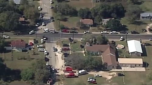
URGENT – IMMEDIATE BROADCAST REQUESTED
Tornado Watch Number 513
NWS Storm Prediction Center Norman OK
345 PM CST Sun Nov 5 2017

The NWS Storm Prediction Center has issued a

* Tornado Watch for portions of
Southern Illinois
Southwest Indiana
Western Kentucky
Southeast Missouri

* Effective this Sunday afternoon and evening from 345 PM until
1000 PM CST.

* Primary threats include…
A few tornadoes likely
Widespread large hail likely with isolated very large hail
events to 2.5 inches in diameter possible
Scattered damaging wind gusts to 70 mph possible

SUMMARY…Intense thunderstorms will continue to develop over
southeast MO and spread across the watch area this afternoon and
evening. Large hail is the main concern, but conditions are also
favorable for a few tornadoes in any persistent supercells.

The tornado watch area is approximately along and 45 statute miles
north and south of a line from 45 miles northwest of Poplar Bluff MO
to 20 miles north northeast of Owensboro KY. For a complete
depiction of the watch see the associated watch outline update
(WOUS64 KWNS WOU3).

PRECAUTIONARY/PREPAREDNESS ACTIONS…

REMEMBER…A Tornado Watch means conditions are favorable for
tornadoes and severe thunderstorms in and close to the watch
area. Persons in these areas should be on the lookout for
threatening weather conditions and listen for later statements
and possible warnings.

&&

Report of multiple victims at church east of San Antonio


WAOI SanAntonio

https://www.ksat.com/news/shooting-sutherland-springs-church-gunfire-mass-shooting-airlife

SUTHERLAND SPRINGS, TX – (KSAT-TV, San Antonio.  Please click on the link above to follow this developing story.  Here is an excerpt below.)

– A man who opened fire in a church in Sutherland Springs, Texas, Sunday morning is dead, police say.

A witness reported seeing a man walk into First Baptist Church and began shooting around 11:30 a.m.

Police said there are at least 20 victims in the church.

The church is located in the 500 block of 4th Street in the small, south Texas town about 40 miles east of San Antonio.

EMERGENCY ALERT DAY DECLARED

Hazzard:  Enhanched risk (Level 3 of 5) of Severe Weather

Timing:  From 5:00 p.m. to 10:00 p.m.

Risk:  large hail, damaging winds, isolated tornadoes, the potential of flash flooding

During the traffic jams of the eclipse, I decided there needed to be something to get attention of the readers.  My criteria is if there is an enhanced risk of severe weather 24 hours in advance, I would declare an emergency alert day.

The latest charts that came down from the Storm Prediction Center, shows the severe threat has increased for Franklin County.

During this time, the majority of news stories will take the back seat.  You might see the whole section of Breaking News be filled up with severe weather information, or any other hazard that is happening in the county.

I have been researching some information for this upcoming event.  The first thing I will post in the morning is updated information from the National Weather Service in Paducah and the SPC.

Through NWS chat, I will see what the weather service, emergency officials, and meteorologists in our market’s opinion.   With the storms taking a NW-SE direction which is typical in the fall, I will start monitoring the stations in the St Louis market.  They stream live during severe weather events.  My preference is KMOV Channel 4,

In a severe weather event, Franklin County is the top priority.  I will try to give as much information as I can for surrounding counties.

I welcome for questions to be asked in a severe weather event.  There could be the possibility that I might not have the time.

While checking your smoke detectors, it would be a time to check your NOAA weather radio’s batteries as well.  I would take the precautions to prepare to lose power.  Always prepare to have two sources of information.

I always quote Jim Rasor during these events, “Be aware, and not afraid.”

Steve


Griffith scores 14 in JUCO debut

JALC women open season with 97-52 win over Lindenwood-Belleville (JV)

CARTERVILLE, IL – Eleven different players scored as Shaniya Whitsell paced the John A. Logan College Lady Vols with 18 points in a 97-52 season-opening win over Lindenwood-Belleville (JV) Saturday afternoon.

Alicia Hornbuckle added 16 points while Morgan Griffith scored 14. Destiny Cozart dropped in 11 points and added seven rebounds. Miriah Donelson racked up 10 points and seven boards.

JALC led 25-9 after the first quarter and enjoyed a 49-16 edge at intermission.

The Lady Vols (1-0) will welcome Missouri Baptist (JV) Nov. 8 at 5 p.m.


Benton, West Frankfort, Illinois News | Franklin County News