TFBC Clothing Room experiences two forced entries/thefts over the last few days

by Steve Dunford

THOMPSONVILLE-  Twice over the last few days, the clothing room of the Thompsonville First Baptist Church has been vandalized, broken into, and thefts have occurred.

The clothing room is located just west of the village limits on State Hwy. 149.  The church has a baseball/softball field there, as well as  a pavilion.  There have been several instances of vandalism over the last several months on the property.

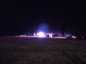
Yesterday, the forced entry happened during broad day light.  Here is the vehicle in suspicion, from the surveillance cameras yesterday.

tville-break-in

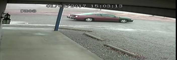
On December 30th security video caught the suspects on camera.  Click on the link for the video.

https://www.facebook.com/natalie.s.dixon/videos/1515382631808652/

If you have any information on this case, please call the Franklin County Sheriff’s office at 438-8211.

EDITORIAL NOTE:   This is a ministry that is trying to express Christ’s love to people by giving them FREE clothing and items.  It perplexes me why someone would want to steal them.  I just have a tough time understanding the mindset of individuals who would take items when all they have to do is ask.  According to ministry coordinator, Natalie Dixon, “They leave a lot of work afterwards from the mess they leave behind.”


Changes in the weather coming soon

Please read Channel 12 meteorologist Brian Alworth's quote toward the end of the link

Please read Channel 12 meteorologist Brian Alworth’s quote toward the end of the link

When you click on this link, it will give you an updated forecast throughout the day. There is an 80% chance of rain today, a stray thunderstorm is possible with a high of 54 degrees. The latest model from the Storm Prediction Center, has the chance of severe weather south of the Ohio River now. The rain chances continue through tomorrow with falling temperatures through the afternoon. Here is the hazardous weather outlook from the National Weather Service in Paducah: DENSE FOG WILL CONTINUE TO BE AN ISSUE FOR AWHILE THIS MORNING… ESPECIALLY OVER PORTIONS OF WESTERN KENTUCKY AND SOUTHWEST INDIANA. A DENSE FOG ADVISORY REMAINS IN PLACE FOR THE ENTIRE REGION THROUGH 9 AM. PLEASE REFER TO THE FOG ADVISORY PRODUCT FOR MORE DETAILS. THERE WILL BE A SLIGHT CHANCE OF THUNDERSTORMS TODAY INTO EARLY TONIGHT…ESPECIALLY OVER WESTERN KENTUCKY. AN ISOLATED DAMAGING WIND GUST CANNOT BE RULED OUT…BUT WIDESPREAD ORGANIZED STORMS ARE NOT EXPECTED. .DAYS TWO THROUGH SEVEN…TUESDAY THROUGH SUNDAY ARCTIC AIR WILL ARRIVE WEDNESDAY. WIND CHILL VALUES DURING THE LATE NIGHT AND MORNING HOURS COULD DIP INTO THE SINGLE DIGITS TO NEAR 10 DEGREES…ESPECIALLY THURSDAY AND FRIDAY MORNINGS. There is a slight chance of snow on Thursday afternoon. Models are still all over the place for a possible snow event this weekend. This is what KFVS TV meteorologist posted on his Facebook page this morning. “Interesting scenario developing for late this week. Cold air will blow into the Heartland about midweek. At first it looks like we’ll be mainly dry (maybe a few flurries, etc.) But by Friday night into Saturday forecast models are indicating we may have a rather significant weather system moving through from west to east. Too early to get really excited (or worried) but at this point it looks like we could get some measurable snow out of this….though as usual the ‘rain/mix/snow’ zone will be somewhere in our region. Stay tuned for likely tweaks.” We will always stay on top of the weather situation here at franklincounty-news.com

Ten o’clock weather update

new-years-dense-fog-advisory


Here is the latest hazardous weather outlook from the National Weather Service:

.DAY ONE…TODAY AND TONIGHT AREAS OF DRIZZLE AND DENSE FOG ARE FORECAST TO SPREAD NORTHWARD ACROSS THE AREA TONIGHT AND CONTINUE THROUGH MID MORNING MONDAY. THE FOG WILL REDUCE VISIBILITIES TO LESS THAN ONE QUARTER MILE IN AREAS. PLEASE REFER TO THE DENSE FOG ADVISORY FOR MORE DETAILS. .DAYS TWO THROUGH SEVEN…MONDAY THROUGH SATURDAY A CHANCE OF THUNDERSTORMS IS FORECAST…MAINLY MONDAY INTO MONDAY EVENING. AN ISOLATED STRONG OR SEVERE STORM CANNOT BE RULED OUT. DAMAGING WIND GUSTS AND LOCALLY HEAVY RAIN WILL BE THE PRIMARY THUNDERSTORM HAZARDS.

The Storm Perdiction center’s latest update shows a mariginal risk for severe weather from about I 24 south.

There is a slight chance of snow showers on Thursday.  Models are all over the place on this.

The website will always keep you informed of severe weather events in real time if possible.

sd


BREAKING: 4 dead in Johnson County plane crash

Picture from the scene (WSIL TV photo)

Picture from the scene (WSIL TV photo)

WSIL — Four people were killed after a small plane crashed in a wooded area southeast of Vienna in Johnson County. The Johnson County coroner said the victims are two adult men and two adult women. Their identities have not been released. The Illinois state police say the victims are from Iowa. The FAA identified the plane as a Piper PA28 and say it crashed under unknown circumstances. Residents said they saw the plane crash into the wooded area near Crossroads Road around 5:45 p.m. on Saturday….Please click on this like to read and watch the video from WSIL News 3….

New years day forecast

day2otlk_0700So far the anticipated snow in the weather charts earlier this weekend is forecasted to be flurries on Thursday. Cloudy and a high of 46 today before the rain settles in and a chance of thunderstorms. We are on the border for a marginal risk of severe weather on Monday. There is a graphic from the storm prediction center attached for tomorrow. This is what the hazardous weather outlook form the National Weather Service says…A CHANCE OF THUNDERSTORMS IS FORECAST…MAINLY MONDAY INTO MONDAY EVENING. AN ISOLATED STRONG OR SEVERE STORM CANNOT BE RULED OUT. DAMAGING WIND GUSTS AND LOCALLY HEAVY RAIN WILL BE THE PRIMARY THUNDERSTORM HAZARDS..Please click on the link for the seven day forecast from the NWS in Paducah for Franklin County

Happy New Year!!!!!!!!

happy-new-year

Other than the forecast, I will not post anything unless it is pertinent information for the residents of Franklin County.  Be safe tonight.  Please do not drink and drive.  I wish you all a prosperous new year in 2017.-sd


A hodgepodge forecast to start the new year

new-years-eve-forecastClick on this link to get the seven day forecast from the National Weather Service for Franklin County. Here is the hazardous weather outlook from the National Weather Service- .DAY ONE…TODAY AND TONIGHT SOUTHERLY WINDS WILL GUST FROM 25 TO 35 MPH TODAY…ESPECIALLY ALONG AND EAST OF THE OHIO RIVER. .DAYS TWO THROUGH SEVEN…SUNDAY THROUGH FRIDAY ISOLATED TO SCATTERED THUNDERSTORMS WILL BE POSSIBLE MONDAY INTO MONDAY EVENING. AN ISOLATED SEVERE STORM OR TWO CANNOT B E RULED OUT…MAINLY OVER WESTERN KENTUCKY. DAMAGING WIND GUSTS WOULD BE THE MAIN THUNDERSTORM HAZARD. .SPOTTER INFORMATION STATEMENT… STORM SPOTTERS SHOULD BE VIGILANT OF UPCOMING FORECASTS CONCERNING THUNDERSTORM POTENTIAL ON MONDAY. They have issued a Special Weather Statement for the windy conditions today for Franklin and all the surrounding counties…I posted a graphic that Brian McCormick from Channel 12 on the FB page last night about the potential of snow around Friday..There must be some weather sites out there that is showing several inches of snow for.. ….I read a social media posts from Grant Dade, Chief Meteorologist from KFVS. This is what he had to say, “A week from tonight an arctic air mass is forecast to move south through the central United States. Cold air is forecast to continue to filter south through at least the following Friday. At the same time southwesterly winds aloft will bring moisture over this cold air. This is when we typically see our winter weather events. It is WAY TOO EARLY to know when, where, or even if this will occur. You will see lots of social media posts over the next few days forecasting lots of snow in areas that rarely see lots of snow. Snowfall forecasts over 8 days out are rarely ever correct. If you see a forecast of 12 or more inches of snow where you live, check the source. Check the forecast time. If it is more than 3 days out chances are it will not be correct. Snow is extremely tricky to forecast. And knowing where a storms will dump a lot of snow over a week out is impossible. I do not know if your area will be hit by snow, no one does this far out. I am saying the overall atmospheric conditions will become favorable for winter weather over the central and southern United States late next week. Stay tuned and we will keep you ahead of the storm.” We will keep you informed of the changing weather conditions on franklincounty-news.com

Sunny, high of 46 degrees today

forecast-12-30Enjoy the clear blue skies and a mild December day today. We have another rainy but mild weekend coming up. Click to read the full forecast for Franklin County from the National Weather Service of Paducah, KY

Franklin County Sheriffs Office seeking suspects over stolen deer stand

Franklin County Sheriff's office photo

Franklin County Sheriff’s office photo

The Franklin County Sheriff’s Office is seeking suspects in the theft of a deer stand in Benton. Anyone who recognizes the truck or has information regarding the incident is asked to call the sheriff’s office at 618-438-4841 or the hotline at 618-439-9252.

Natural Gas Smell in West Frankfort not a leak

This statement was issued on the West Frankfort Fire Department’s Facebook page:

We have been receiving several reports of a natural gas smell around town. We have investigated each report but, so far, we have west-frankfort-logonot found any sign of dangerous gas on our meters.

This problem occurs quite often in our area during the winter. We believe the odor to be Hydrogen Sulfide or a methane gas that may be the byproduct of oil wells or coal mines in the area. While these gases can be dangerous in high concentrations, when outside in open air, they generally will not reach levels high enough to be harmful.

If you smell a strange odor inside your home or near a gas line or gas meter, and have concern that it could be dangerous please feel free to contact us or your gas provider and we will gladly come check it for you.

Benton, West Frankfort, Illinois News | Franklin County News