Benton, West Frankfort, Illinois News | Franklin County News
Newspaper covering Franklin County, Illinois
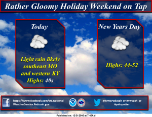
Click on this link to get the seven day forecast from the National Weather Service for Franklin County. Here is the hazardous weather outlook from the National Weather Service- .DAY ONE…TODAY AND TONIGHT SOUTHERLY WINDS WILL GUST FROM 25 TO 35 MPH TODAY…ESPECIALLY ALONG AND EAST OF THE OHIO RIVER. .DAYS TWO THROUGH SEVEN…SUNDAY THROUGH FRIDAY ISOLATED TO SCATTERED THUNDERSTORMS WILL BE POSSIBLE MONDAY INTO MONDAY EVENING. AN ISOLATED SEVERE STORM OR TWO CANNOT B E RULED OUT…MAINLY OVER WESTERN KENTUCKY. DAMAGING WIND GUSTS WOULD BE THE MAIN THUNDERSTORM HAZARD. .SPOTTER INFORMATION STATEMENT… STORM SPOTTERS SHOULD BE VIGILANT OF UPCOMING FORECASTS CONCERNING THUNDERSTORM POTENTIAL ON MONDAY. They have issued a Special Weather Statement for the windy conditions today for Franklin and all the surrounding counties…I posted a graphic that Brian McCormick from Channel 12 on the FB page last night about the potential of snow around Friday..There must be some weather sites out there that is showing several inches of snow for.. ….I read a social media posts from Grant Dade, Chief Meteorologist from KFVS. This is what he had to say, “A week from tonight an arctic air mass is forecast to move south through the central United States. Cold air is forecast to continue to filter south through at least the following Friday. At the same time southwesterly winds aloft will bring moisture over this cold air. This is when we typically see our winter weather events. It is WAY TOO EARLY to know when, where, or even if this will occur. You will see lots of social media posts over the next few days forecasting lots of snow in areas that rarely see lots of snow. Snowfall forecasts over 8 days out are rarely ever correct. If you see a forecast of 12 or more inches of snow where you live, check the source. Check the forecast time. If it is more than 3 days out chances are it will not be correct. Snow is extremely tricky to forecast. And knowing where a storms will dump a lot of snow over a week out is impossible. I do not know if your area will be hit by snow, no one does this far out. I am saying the overall atmospheric conditions will become favorable for winter weather over the central and southern United States late next week. Stay tuned and we will keep you ahead of the storm.” We will keep you informed of the changing weather conditions on franklincounty-news.com
You must be logged in to post a comment.
December 29, 2024
Columns Archives...


Speak Your Mind
You must be logged in to post a comment.