The National Weather Service in Paducah has issued a Wind Advisory, which is in effect until 6 PM CST this evening for the following counties, ALEXANDER … FRANKLIN … JACKSON … JEFFERSON … PERRY … UNION.
* TIMING…This afternoon.
* WINDS…South southwest winds will gust 40 to 50 mph.
* IMPACTS…Vehicular traffic, especially for high profile
vehicles, will be affected with rough driving conditions. Mobile
homes and outdoor construction work will be affected. Choppy
waves on area water bodies will make boating hazardous,
especially on Rend Lake.
PRECAUTIONARY/PREPAREDNESS ACTIONS…
A wind advisory is issued when sustained winds are expected to
reach 30 mph or greater for longer than one hour…or wind gusts
are expected to reach 40 mph for any duration.
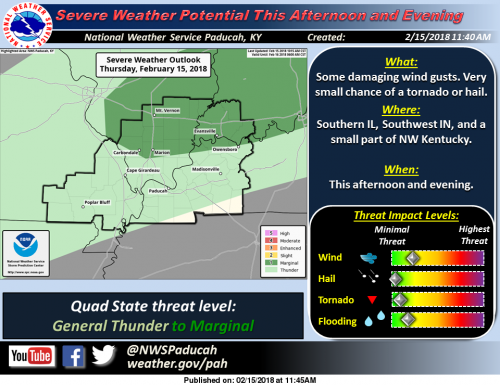
Hazardous Weather Outlook
.DAY ONE…Today and Tonight
There is a chance of thunderstorms tonight, with heavy rainfall
possible, mainly after midnight.
South winds may gust around 35 mph or slightly higher today.
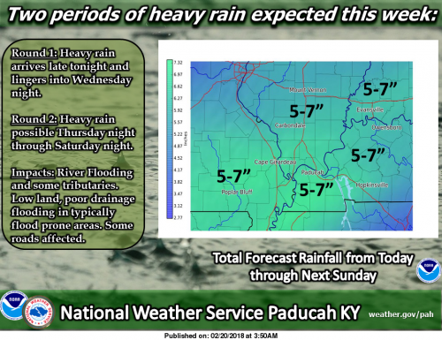
.DAYS TWO THROUGH SEVEN…Wednesday through Monday
The rains late Tuesday through Wednesday night will likely set the
stage for the possibility of areal flooding mid to late week, as
rounds of widespread showers and a few thunderstorms are expected,
producing multiple periods of heavy rainfall across the region
Thursday night through Saturday night. The flooding concern will
increase with each round of heavy rainfall, culminating with the
cold frontal passage Saturday night. A few strong storms cannot be
ruled out Saturday.
.SPOTTER INFORMATION STATEMENT…
Rainfall measurements from our spotters are requested, along with
any reports of observed flooding later in the week.
Hydrologic Outlook
The forecast weather pattern this week continues to support
multiple rain episodes, that will likely result in several inches of
rain. An initial round is expected from late tonight through
Wednesday night. Additional rains will come later in the week,
especially from Thursday night through Saturday night.
The main concern with this week`s rainfall will be the potential
for additional flooding of rivers and their tributaries. Flooding of
low land and poor drainage areas will become likely mid to late
week. We may see some flooding develop on roads that typically
experience water problems during longer duration heavy rain events,
again from mid to late week.
Stay tuned for later statements and updates.
Seven Day Outlook
This Afternoon
A 40 percent chance of showers, mainly after 4pm. Cloudy, with a high near 73. Breezy, with a south wind 16 to 21 mph, with gusts as high as 37 mph.
Tonight
Showers and possibly a thunderstorm. Some of the storms could produce heavy rainfall. Patchy fog after 10pm. Low around 37. South wind 13 to 16 mph becoming north northwest after midnight. Winds could gust as high as 26 mph. Chance of precipitation is 100%.
Wednesday
Showers. High near 39. North wind 10 to 13 mph, with gusts as high as 21 mph. Chance of precipitation is 100%.
Wednesday Night
Showers. Low around 37. Northeast wind 8 to 10 mph. Chance of precipitation is 80%.
Thursday
A 30 percent chance of showers, mainly before noon. Cloudy, with a high near 51. Northeast wind 5 to 8 mph.
Thursday Night
Showers likely, then showers and possibly a thunderstorm after midnight. Low around 48. East wind around 6 mph becoming south after midnight. Chance of precipitation is 80%.
Friday
Showers and possibly a thunderstorm before noon, then a chance of showers. High near 58. South southwest wind around 6 mph becoming north northeast in the afternoon. Chance of precipitation is 90%.
Friday Night
Showers likely, then showers and possibly a thunderstorm after midnight. Cloudy, with a low around 49. East wind 5 to 10 mph becoming south after midnight.
Saturday
Showers and possibly a thunderstorm. Cloudy, with a high near 62. South southwest wind 8 to 10 mph.
Saturday Night
Showers likely and possibly a thunderstorm before midnight, then a slight chance of showers. Mostly cloudy, with a low around 41. South southwest wind 9 to 14 mph becoming west after midnight. Winds could gust as high as 22 mph.
Sunday
Mostly sunny, with a high near 54. West northwest wind 6 to 14 mph, with gusts as high as 23 mph.
Sunday Night
Mostly clear, with a low around 36. West southwest wind around 6 mph becoming southeast after midnight.
Monday
Sunny, with a high near 57. South southeast wind 5 to 10 mph becoming west southwest in the afternoon.