Gov. Rauner attends Janus v. AFSCME arguments before SCOTUS


Tom Dart


Former Ald. Daniel Solis leaves Dirksen U.S. Courthouse after testifying in the corruption trial of former Speaker Michael Madigan.
Happy New Year! Blessings to you and your family in 2025!
Press Release from Gov. Bruce Rauner’s administration 

WASHINGTON, D.C. — Governor Bruce Rauner today attended oral arguments before the Supreme Court of the United States on Janus v. AFSCME, a landmark court case initiated by the administration that aims to restore free speech to public employees and forever alter the relationship between taxpayers and public unions.

Rallying from both sides of the issue outside the Supreme Court in Washington. (State of Illinois website.)

“Shortly after taking office in 2015, I took action to protect the free speech and free association rights of government employees who are forced to pay union dues and fund political causes they don’t agree with,” said Rauner. “Today, as these arguments are heard before the United States Supreme Court, I am proud of what we started three years ago. The gravity of the court’s decision will be felt not just in Illinois, but across America and I am confident that they will side with free speech for the people of our great nation.”

In 2015, the Rauner administration issued an executive order – and filed Rauner v. AFSCME in federal court – making it illegal for public sector unions to collect dues from government workers who opted out of a union. When a federal judge ruled that, as governor, Rauner didn’t have standing to represent workers in the suit, Mark Janus, an employee of the Illinois Department of Healthcare and Family Services stepped in.

The Rauner administration wants to change a law that requires public employees to pay dues even if they aren’t in the union, a practice that has gone on in America for the last 40 years.

“No person should be forced to give up a portion of their pay each month to fund public sector union activity,” Rauner said. “It’s a fundamental violation of cherished American rights to free speech and free association.”


RLCD board passes 2.5 percent water rate hike

WSIL image

BENTON – Water will be a bit more expensive for hundreds of thousands of people in southern Illinois.

The Rend Lake Conservancy District board passed a 2.5 percent rate hike Monday morning.

Rend Lake Conservancy District General Manager Keith Thomason said the increase gives the district flexibility down the road to complete repairs.

“The Rend Lake Conservancy District is attempting to make these repairs and never have a significant rate increase, which means we have to look into the future and that we will not ever go cash negative,” Thomason said. “We’re going to pay as we go and we are not going to take big debt which then burdens our children in the future years to pay that debt for us.”

Please click on the link for the full story from Joe Ragusa of WSIL-TV

http://www.wsiltv.com/story/37596447/rlcd-board-passed-25-percent-water-rate-hike

Franklin County Sheriff’s office non emergency lines down

From Franklin County Emergency Management Agency

BENTON –  Franklin County Sheriff’s Office Dispatch Center is experiencing a phone outage on their non-emergency lines. Until further notice, please use 618-435-2250 for non-emergency calls to the Sheriff’s Office.

DO NOT CALL 911 UNLESS IT IS AN EMERGENCY!!!!!!!!

UPDATE 9:30 a.m.  I just was in contact with Franklin County EMA, and the lines are still down according to their last report.

Benton Mayor Lobbying for Federal Infrastructure Money

BENTON – During the Public Affairs Report at the Feb. 12 Benton City Council meeting, Mayor Kondritz said that Benton’s water department and infrastructure had been under a lot of stress due to recent weather and the aging of the city’s water and sewer lines.

 “I saw where President Trump introduced a $1.5 trillion (budget) bill, and I don’t care what you think about that situation. What I care about is that as the City of Benton, I want our slice of the federal pie,” Kondritz said.
Please click on the link for the full story from the Benton Gazette.

Enjoy this nice day……showers moving into the area starting tonight

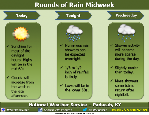
We will have one more mild day with sunshine today, with a southerly breeze, though clouds will increase from the west in the late afternoon. As a disturbance aloft moves across the region, showers are expected primarily after midnight tonight, amounting to less than an inch of rainfall. Clouds will remain Wednesday, with fewer showers around. Wednesday night, rain is expected to return with a vengeance, especially south of the Ohio River, as a low pressure system rolls by just to the north. Some thunderstorms are possible in the northern half of the region. Low lying and flood prone areas could have water issues. (NWS Paducah)

Flood Warning Continues on the Big Muddy Until Thursday

…The flood warning continues for the following rivers in
Illinois…

Big Muddy River near Plumfield
Big Muddy River near Murphysboro

.Flooding continues along the Big Muddy River. The river will crest
at Plumfield tonight at 23.2 feet and fall below flood stage on
Thursday morning. At Murphysboro the river will rise to moderate
flood stage tonight and crest at 30.5 feet Wednesday morning.

PRECAUTIONARY/PREPAREDNESS ACTIONS…

SAFETY MESSAGE…

Never drive cars…trucks or sport utility vehicles through flooded
areas. The water may be too deep to allow safe passage. Never allow
children to play in or near flood waters. Stay tuned to NOAA Weather
Radio or your local media for further statements and possible updated
forecasts.

Hazardous Weather Outlook

.DAY ONE…Today and Tonight

A 1/3 to 1/2 inch of rainfall is forecast across the region
tonight.

Numerous river flood warnings remain in effect. Please refer to
the warning products and their follow up statements for details.

.DAYS TWO THROUGH SEVEN…Wednesday through Monday

Additional rainfall of 1/3 inch northwest to 1 1/3 inch southeast
is forecast across the region during the Wednesday through
Thursday time frame. A chance of thunderstorms forecast for the
northern half of the region on Wednesday night will heighten the
risk for locally heavy rainfall amounts there. Refer to the
Hydrologic Outlook for more detailed information on this mid week
rain chance and its potential impacts.

Windy conditions are likely on Thursday behind a cold front.
Northwest winds could gust 30 to 40 mph at times.

A slight chance of thunderstorms is forecast for the entire region
Monday. Locally heavy rainfall will be the primary concern.

River flood warnings will remain in effect through much of the
week. Refer to the flood warnings and statements for important
river flood details, including the latest updated information.

Hydrologic Outlook

…ONE TO AS MUCH AS TWO INCHES OF RAINFALL POSSIBLE…

Another rain event is coming for the middle of this week for the
region. The rain will begin tonight, and will end Thursday.
During that time, we expect average rainfall to total between a
half inch across the northwestern tier of counties in southeastern
Missouri and southern Illinois, to nearly two inches close to the
Tennessee state line. Locally higher amounts in thunderstorms,
which are forecast for Wednesday night in the northern half of the
region, could cause rainfall totals to reach into the 1 to 2 inch
range there by the end of the day Thursday.

This amount of rainfall would not normally cause many issues.
However, given the still wet ground conditions from last week`s
rains, and the forecasted crests of river stages, you should
monitor local water conditions closely as this next rain occurs.
Low lands and poorer drainage areas may flood more quickly than
usual. This may extend ponding or flooding of water overtop back
country roads, especially ones near creeks and streams that may
swell more quickly than usual.

Stay tuned to all the latest forecasts and updates and keep an eye
for rising waters as rains hit during the mid week period.

Seven Day Forecast

Today
Increasing clouds, with a high near 65. South wind 6 to 14 mph, with gusts as high as 20 mph.
Tonight
Showers, mainly after midnight. Low around 50. South wind 7 to 10 mph. Chance of precipitation is 90%.
Wednesday
Showers likely, mainly before noon. Patchy fog after noon. Otherwise, cloudy, with a high near 62. East southeast wind around 7 mph becoming south southwest in the afternoon. Chance of precipitation is 60%.
Wednesday Night
Showers likely, with thunderstorms also possible after midnight. Cloudy, with a low around 49. South wind 6 to 10 mph, with gusts as high as 18 mph. Chance of precipitation is 70%.
Thursday
A 40 percent chance of showers before noon. Partly sunny, with a high near 54. Breezy, with a west southwest wind 11 to 20 mph becoming northwest in the afternoon. Winds could gust as high as 33 mph.
Thursday Night
Mostly clear, with a low around 32. North northwest wind 8 to 15 mph, with gusts as high as 25 mph.
Friday
Sunny, with a high near 50. North northeast wind 5 to 8 mph.
Friday Night
Clear, with a low around 31. East northeast wind around 6 mph.
Saturday
Sunny, with a high near 54. East southeast wind 5 to 7 mph.
Saturday Night
Clear, with a low around 34. East wind around 7 mph.
Sunday
Sunny, with a high near 57. Southeast wind around 8 mph.
Sunday Night
A chance of showers. Mostly cloudy, with a low around 42. Southeast wind around 9 mph.
Monday
A chance of showers and thunderstorms. Mostly cloudy, with a high near 54. South wind around 10 mph becoming west northwest in the afternoon.


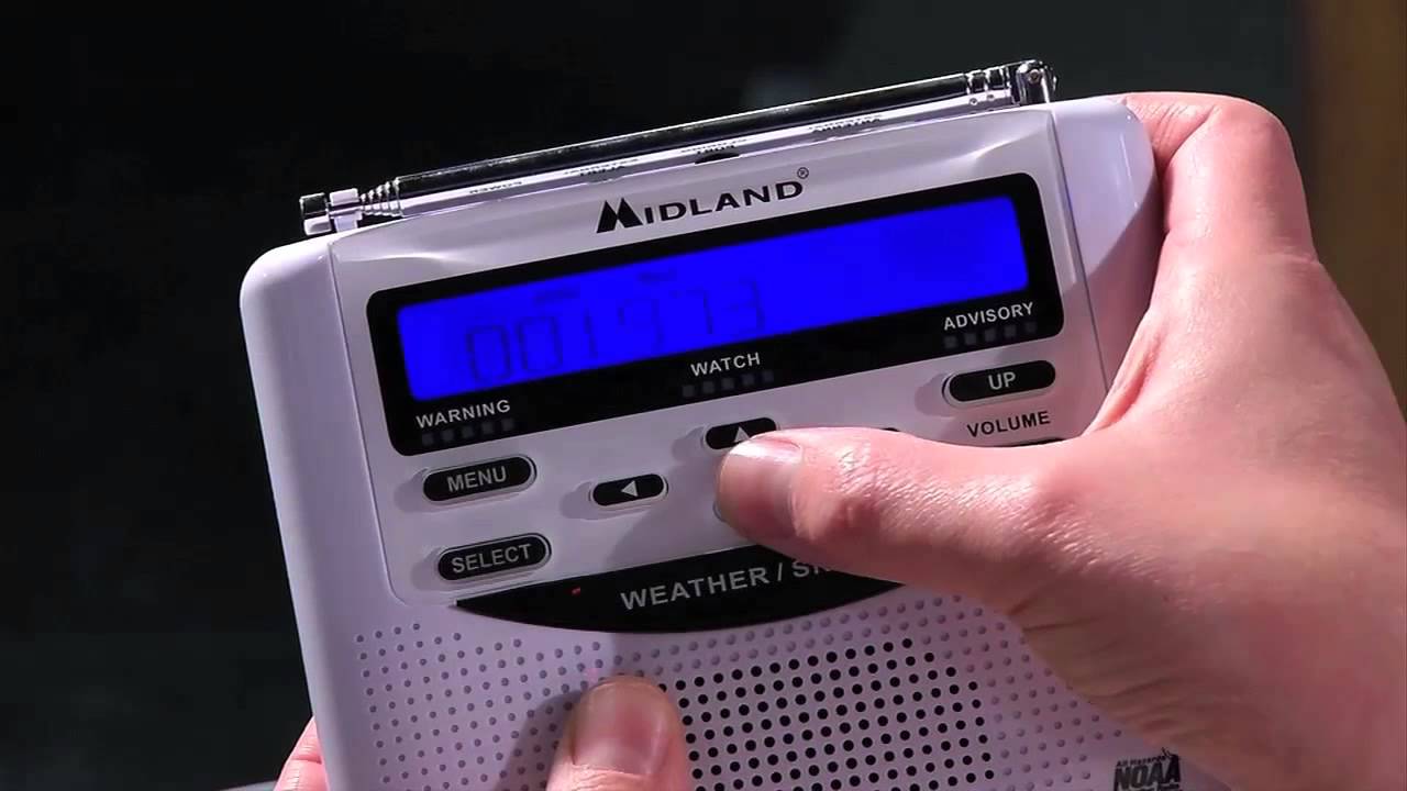
Franklin County EMA programming NOAA Weather Radios at Benton/West City Walmart

WEST CITY –  Join the Franklin County Emergency Management Agency, West City Fire Department during Severe Weather Preparedness Week for a FREE NOAA All-Hazards Radio Programming Event.  This will take place at the West City Walmart on Monday, March 5th between 8:00-4:00 p.m.

Please bring your radio by or purchase one at Walmart and we will program your radio to ensure you are weather ready!

Also, FCEMA will take part in basic storm spotter training that evening in West City.  Details will be coming soon. -sd

West Frankfort-based Da Vinci Beverages allegedly owes a local marketing firm between $10,000 and $50,000

BENTON — Da Vinci Beverages is being sued by Marion-based marketing firm James Arthur and Company for several counts of breach of contract.

The complaint, filed in Franklin County Court in December, asks that the court require Da Vinci, a member of the Morthland family of businesses, to pay between $10,000 and $50,000.

The complaint alleges that Da Vinci entered into a contract with JAC in January 2017 for social media marketing and other branding services.

Please click on the link below for the full story from Isaac Smith of the Southern Illinoisan.

http://thesouthern.com/news/local/crime-and-courts/west-frankfort-based-da-vinci-beverages-allegedly-owes-a-local/article_e7e36e3d-8dab-507d-aec3-fecf1b49e417.html#tracking-source=home-trending

Four from Franklin County advance to the Country Financial Three Point Showdown

Three Franklin County seniors will get to slip on their uniforms one more time shooting in the sectional finials of the Country Financial Three Point Showdown.

West Frankfort Seniors Lucas Wolfe and Brendan Russell will represent the Redbirds at the Trenton-Wesclin Class 2A Sectional.

Jared Curry, along with freshman Kye Garver, will be shooting for the Christopher Bearcats at the Hardin County Class 1A Sectional.

The contest starts at 5:00 p.m. state-wide -sd

Illinois Spring Trout Fishing Season Opens April 7

Spring Catch-and-Release Fly Fishing Season Opens March 24 at select sites

SPRINGFIELD, IL – The 2018 Illinois Spring Trout fishing season is just a few weeks away. Anglers will need both a fishing license and an Inland Trout Stamp to participate, unless they are under the age of 16, blind, disabled, or are an Illinois resident on leave from active duty in the Armed Forces.

Licenses and trout stamps will be available for purchase on the Illinois Department of Resources (IDNR) website and at DNR Direct license and permit locations, including many bait shops, sporting goods stores and other retail outlets, starting Thursday, March 1.

The Spring Catch-and-Release Fly Fishing season opens at nine sites on March 24.  Anglers can use fly fishing gear to catch trout at that time, but they cannot keep the fish. All trout must be released until after the opening of the regular spring trout season, which begins at 5 a.m. on April 7. Anyone attempting to take trout before the legal harvest season opening will be issued citations.

The IDNR stocks more than 80,000 rainbow trout each year, with 54 ponds, lakes and streams throughout the state being stocked for the spring season, and an additional 80,000 trout stocked for the fall season.

For more information on trout seasons and other Illinois fishing opportunities, check the website at www.ifishillinois.org.

For more information about all site regulations, anglers should contact individual sites that will be stocked with catchable-size trout. Not all sites open at 5 a.m. on opening day. Anglers are reminded to check the opening time of their favorite sites prior to the opening date.

For those sites in the southern end of the state.

South — Jefferson County — Mount Vernon Game Farm Pond
South — Johnson County — Ferne Clyffe State Park Lake
South — Marion County — Boston Pond, Stephen A. Forbes State Recreation Area
South — Massac County — Fairgrounds Pond, Fort Massac State Park
South — Randolph County — Derby Lake, Sparta (World Shooting and Recreational Complex)
South — St. Clair County — Frank Holten State Park Main Lake
South — St. Clair County — Jones Park Lake, East St. Louis
South — St. Claire County — Willow Lake at Peabody River King State Fish and Wildlife Area **
South — Wabash County — Beall Woods Lake, Beall Woods State Park
South — Wayne County — Sam Dale Trout Pond, Sam Dale Lake State Fish and Wildlife Area

February 24, 2018 Severe Weather and Flooding Summary


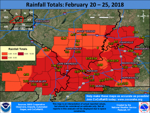
PADUCAH, KY – Multiple waves of precipitation moved through our region from the evening of February 20th through the morning of February 24th. A warm front lifted across the region on Saturday afternoon, followed by a cold front that quickly moved through during the late afternoon and evening hours. Severe thunderstorms accompanied this system with damaging winds and a few tornadoes, including two EF-2 tornadoes that occurred in the Hopkinsville, KY and Matthews, MO areas. Please note that damage surveys are still ongoing with this event! There was also widespread flooding across our area due to 5 to 8 inches of rain falling over a 4 to 5 day period. Flash flood warnings were in effect for the vast majority of the region late Saturday afternoon and evening.

Please click on the link for an interactive web page from the National Weather Service of Paducah Ky.

http://www.weather.gov/pah/2018_Feb24_EventSummary

Benton, West Frankfort, Illinois News | Franklin County News