ST LOUIS, MO – (Alexandria Martellaro – KSDK -TV. Please click on the link above to read the full statement by the Cardinal organization. Here is the introduction below.)
Each year, Christian Day at Busch Stadium is one of several community theme nights hosted by the Cardinals. Most years feature a keynote speaker who speaks about how Christianity has impacted their life in sports.
This year’s speaker, former Cardinal Lance Berkman, has made headlines, with some saying he’s been an outspoken opponent of the LGBT community.
Christian Day will take place on Sunday, July 30.
 Carl Dean Webb, 73, of Christopher passed away on May 30, 2017 at 6:50 PM at the Franklin Hospital in Benton. He was born on January 10, 1944 in Christopher to Carl Steven and Lela (Jones) Webb. He married Betty Jean (Grgek) Webb on January 3, 1965 and she survives of Christopher.
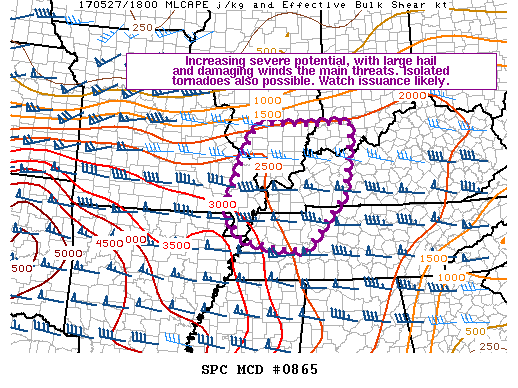
 The Severe Thunderstorm Watch has been cancelled for all the counties north of the Route 13 corridor. Williamson, Saline, Gallatian and the southern seven counties still remain in the watch.
 The NWS Storm Prediction Center has issued a * Severe Thunderstorm Watch for portions of Southern Illinois Southwest Indiana Western and south-central Kentucky Far southeast Missouri Western and middle Tennessee * Effective this Saturday afternoon from 515 PM until Midnight CDT.
 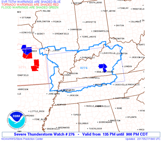 The NWS Storm Prediction Center has issued a * Severe Thunderstorm Watch for portions of Southern Illinois Southern Indiana Western and Central Kentucky Southeast Missouri Northern Tennessee * Effective this Saturday afternoon and evening from 135 PM until 900 PM CDT.