WSIL TV Photo
Benton, West Frankfort, Illinois News | Franklin County News
Newspaper covering Franklin County, Illinois
Press Release by State Representative Dave Severin
SPRINGFIELD, IL – Yesterday, the Illinois House of Representatives passed House Bill 40 will allow taxpayer funds to cover abortions.
After the vote, Representative Dave Severin (R-Benton) expressed his disapproval with the bill both on fiscal and moral grounds.
“As a member of the House of Representatives this is a tough day, as many of my colleagues voted in favor of legislation to expand taxpayer funded access to abortion,” Rep. Severin said. “As the bill’s sponsor admitted, we do not know how much this expansion is going to cost us. Aside from that, HB 40 is a blatant attack on the most vulnerable in our society. It is a shame that we are still dealing with these attacks. As a taxpayer and a Christian, I am offended that Chicago Democrats would dump the unknown cost of this disgusting practice on the taxpayers in all corners of the state.”
Press Release by Franklin County Sheriff, Donald R. Jones
On April 25, 2017 at 3:23 p.m. Deputies responded to a traffic crash on Illinois Rt. 37 at Yellow Banks Road. A 2006 Dodge Caravan driven by Steven E. Lampley Age 43 of Benton was north bound on Rt. 37 and had stopped in traffic to make a left turn onto Yellow Banks Road (West).
A 2003 Ford Mustang, also north bound, failed to stop and struck the Caravan in the rear. The mustang was driven by Nilo A.R Korolenko Age 21 of West Frankfort. The driver of the Mustang suffered minor injuries but refused medical treatment. He was ticketed for failure to reduce speed to avoid an accident.
Three passengers in the Mustang received major injuries. A 19 year old female and a 55 year old male were transported to an area hospital by West Frankfort Fire Ambulance and Abbott’s E.M.S. A 20 year old male was flown from the scene by Air Evac to a St. Louis Hospital. Steven Lampley received major injuries as did his two passengers, a 55 year old male and a 52 year old male. All three were transported to a local hospital by Abbott’s E.M.S. and the West Frankfort Fire Ambulance.
On April 25, 2017 at 4:37 p.m. Deputies responded to a traffic crash on the intersection of Ewing Road and Camp Hope road, east of the village of Ewing.
A 2011 Chevrolet Eqinox driven by Stacy Manning, 31 of Benton was southbound on Camp Hope Road and failed to stop at the intersection.
A 2002 F-250 pickup driven by Chad T. Fisher, 36 of Zanesville OH, was west bound on Ewing Road and struck the Equinox.
Both drivers received minor injuries and refused medical treatment. Manning was ticketed for disobeying a stop sign and for operating an uninsured motor vehicle.
by Steve Dunford
I am going to share several products. With a rainout already declared in St. Louis, it is guaranteed a lot rain is heading that way. Area athletic directors need to pay close attention.
There are Severe thunderstorm Warnings issued in Southeast Missouri already. Southern Illinois should be under the gun around first pitch time of High School baseball and softball (4:00 to 4:30 p.m.) if not before them.
I have been pretty concerned about Friday for a few days now. There is an enhanced (level 3 of five) risk of Severe Weather. The Storm Perdiction Center has everything from west of Interstate 57 and south of Interstate 64 with hatch marks which means the confidence is high.
Sunday is a day to keep your eye out on as well. We are going to experience several inches of rain during this period, so watch for flash flooding and if you are in a low lying area that is flood prone, keep aware of upcoming forecasts.
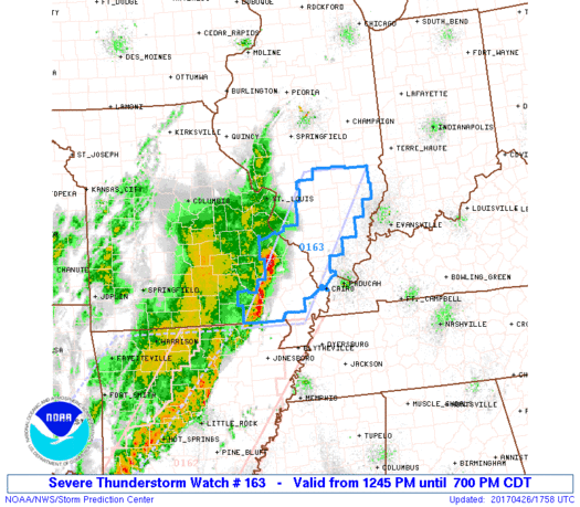
Here are several statements from the National Weather Service and storm prediction regarding the severe weather events now and in the future.
URGENT – IMMEDIATE BROADCAST REQUESTED Severe Thunderstorm Watch Number 163 NWS Storm Prediction Center Norman OK 1245 PM CDT Wed Apr 26 2017
The NWS Storm Prediction Center has issued a * Severe Thunderstorm Watch for portions of Southern Illinois Southeast Missouri * Effective this Wednesday afternoon and evening from 1245 PM until 700 PM CDT. * Primary threats include… Scattered large hail and isolated very large hail events to 2 inches in diameter possible Scattered damaging wind gusts to 70 mph possible
SUMMARY…A line of thunderstorms over southeast MO will likely intensify and track northeastward across the watch area. Damaging winds and hail will be the main threats with these storms. The severe thunderstorm watch area is approximately along and 40 statute miles east and west of a line from 40 miles north northeast of Salem IL to 25 miles south of Poplar Bluff MO.
PRECAUTIONARY/PREPAREDNESS ACTIONS… REMEMBER…A Severe Thunderstorm Watch means conditions are favorable for severe thunderstorms in and close to the watch area. Persons in these areas should be on the lookout for threatening weather conditions and listen for later statements and possible warnings. Severe thunderstorms can and occasionally do produce tornadoes. &&
Hazardous Weather Outlook
This Hazardous Weather Outlook is for portions of southern Illinois, southwest Indiana, western Kentucky, and southeast Missouri. .DAY ONE…Today and Tonight The development of isolated thunderstorms cannot be ruled out over southeast Missouri and southwest Illinois through early this afternoon. Severe weather is not expected with this activity.
Strong to potentially severe thunderstorms are expected to form along and ahead of a cold front over southeast Missouri by mid to late afternoon. Initially, storms will be capable of producing large hail, damaging winds, and an isolated tornado. A line of thunderstorms should progress into southern Illinois and far western Kentucky by early evening. Damaging winds will be the primary concern. The severe threat will diminish quickly as the storms move east towards the Wabash River and the Land Between the Lakes by late evening. Lightning and locally heavy rain will also accompany thunderstorm activity. .
DAYS TWO THROUGH SEVEN…Thursday through Tuesday Multiple rounds of thunderstorms are expected Friday through Sunday. Heavy rainfall is expected over portions of the region. Please refer to the Hydrologic Outlook for details. In addition, strong to severe thunderstorms will be possible through the period. At this time, the best chance of severe storms appears to be with a warm frontal passage Friday night, in addition to the cold frontal passage Sunday.
Hydrologic Outlook National Weather Service Paducah KY 230 AM CDT Wed Apr 26 2017 ...
Heavy rainfall possible Friday through Sunday… Several rounds of showers and thunderstorms are expected to move across the area during this time period. The potential for heavy rain is highest starting Friday night and continuing through Sunday evening.
Rainfall amounts and locations are subject to change, but there has been a fairly consistent signal to focus the heaviest amounts over portions of southeast Missouri into southwest Illinois. This area could see 3 to 5 inches with some locally higher amounts possible. Amounts are expected to be lighter further east over western Kentucky and southwest Indiana.
There may be a break in the precipitation on Saturday at many locations as a warm front lifts north out of the region. However, heavy rainfall chances will increase again Saturday night into Sunday as a cold front approaches from the west. The heavy rainfall is expected to cause rises on some area rivers, particularly the smaller rivers in southeast Missouri such as the Saint Francis, Black, and Current. Minor to moderate river flooding is possible. Confidence is high that heavy rain will fall, but confidence is lower as to the exact location of the heaviest rainfall. Stay tuned for later updates or watches concerning this heavy rain event.
House bill 40, which expands abortion coverage to state employees and Medicaid recipients, in all cases, passed the Illinois House of Representatives today 62-55.
All three Southern Illinois Leguslatiors; Dave Severin (R-Benton), Terri Bryant (R-Murphysboro, and Brandon Phelps (D-Norris City), held to their pro-life convictions and voted against the bill.
Governor Bruce Rauner has vowed to veto the bill, which the house does not have the 3/5th majority to override the veto.
sd
Today, there was a construction project started on southbound Interstate 57 between Benton and West Frankfort. Traffic is backed up for miles going southbound.
There has been an accident reported at State Route 37 and Yellowbanks also between Benton and West Frankfort.
Seek alternate routes.
sd
by Steve Dunford
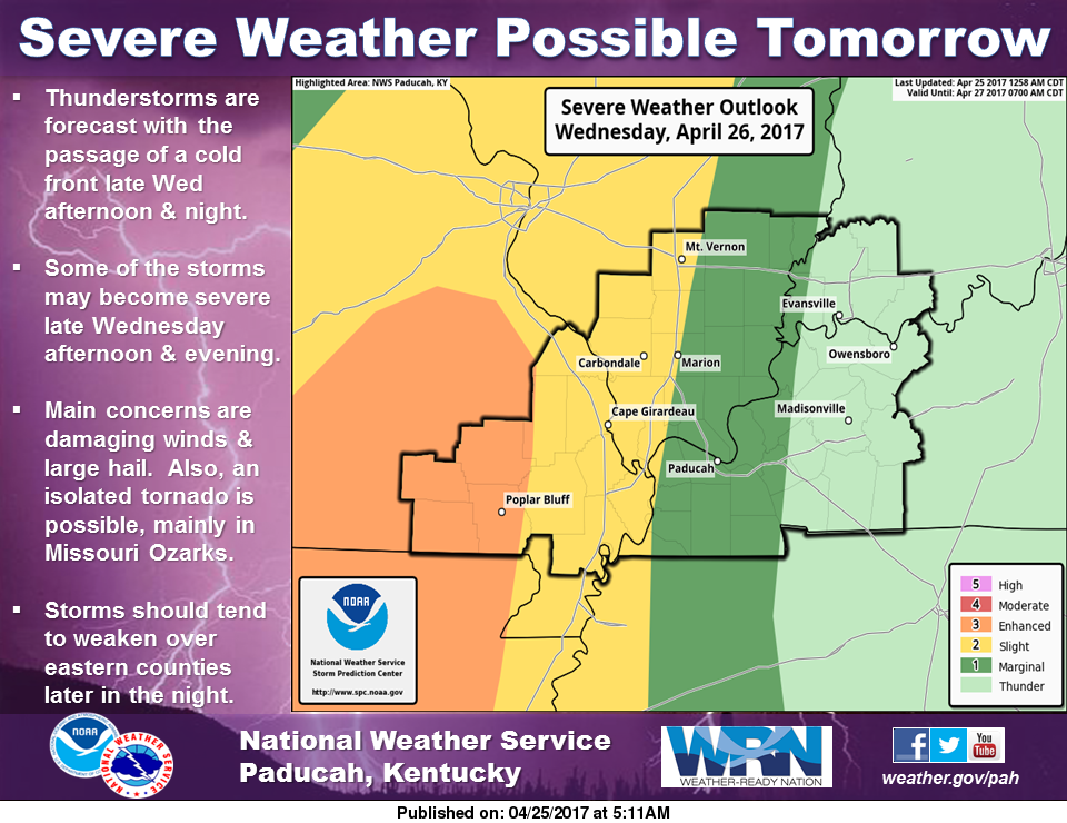 For tomorrow, mainly for the early evening hours and up until midnight there is a slight risk of Severe Weather for the western half of Southern Illinois.
From a briefing from the National Weather Service of Paducah KY, between 9:00 to 10:00 pm is when Franklin County will be under the gun.
The national weather service has not issued a hazardous weather outlook for today. I will post the briefing on the FranklinCounty-news.com Facebook page.
The weekend is going to be very wet. Forecast models are showing five inches of rain here fore the weekend. The Storm Prediction Center has a chance for severe weather slated just to our south for Saturday and Sunday.
For HS sports activities, I would keep my eye to the sky on Wednesday and Friday afternoon for the possibility of pop up thunderstorms.
I will post another update in the morning. I will post watches and warnings when they are issued for the region.
Press release from Franklin County Sheriff Donald R. Jones