by Steve Dunford
I am going to share several products. With a rainout already declared in St. Louis, it is guaranteed a lot rain is heading that way. Area athletic directors need to pay close attention.
There are Severe thunderstorm Warnings issued in Southeast Missouri already. Southern Illinois should be under the gun around first pitch time of High School baseball and softball (4:00 to 4:30 p.m.) if not before them.
I have been pretty concerned about Friday for a few days now. There is an enhanced (level 3 of five) risk of Severe Weather. The Storm Perdiction Center has everything from west of Interstate 57 and south of Interstate 64 with hatch marks which means the confidence is high.
Sunday is a day to keep your eye out on as well. We are going to experience several inches of rain during this period, so watch for flash flooding and if you are in a low lying area that is flood prone, keep aware of upcoming forecasts.
Here are several statements from the National Weather Service and storm prediction regarding the severe weather events now and in the future.
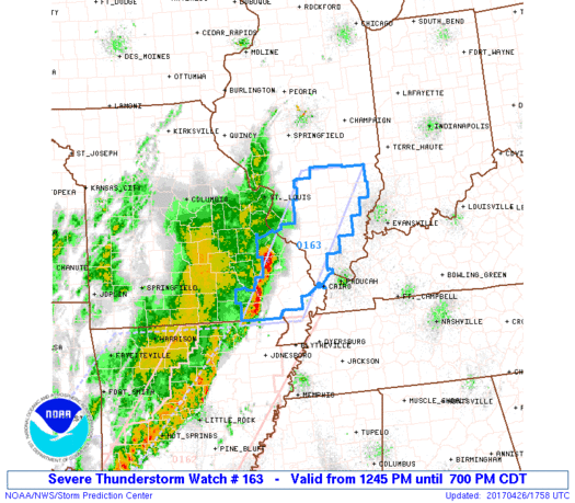
URGENT – IMMEDIATE BROADCAST REQUESTED Severe Thunderstorm Watch Number 163 NWS Storm Prediction Center Norman OK 1245 PM CDT Wed Apr 26 2017
The NWS Storm Prediction Center has issued a * Severe Thunderstorm Watch for portions of Southern Illinois Southeast Missouri * Effective this Wednesday afternoon and evening from 1245 PM until 700 PM CDT. * Primary threats include… Scattered large hail and isolated very large hail events to 2 inches in diameter possible Scattered damaging wind gusts to 70 mph possible
SUMMARY…A line of thunderstorms over southeast MO will likely intensify and track northeastward across the watch area. Damaging winds and hail will be the main threats with these storms. The severe thunderstorm watch area is approximately along and 40 statute miles east and west of a line from 40 miles north northeast of Salem IL to 25 miles south of Poplar Bluff MO.
PRECAUTIONARY/PREPAREDNESS ACTIONS… REMEMBER…A Severe Thunderstorm Watch means conditions are favorable for severe thunderstorms in and close to the watch area. Persons in these areas should be on the lookout for threatening weather conditions and listen for later statements and possible warnings. Severe thunderstorms can and occasionally do produce tornadoes. &&
Hazardous Weather Outlook
This Hazardous Weather Outlook is for portions of southern Illinois, southwest Indiana, western Kentucky, and southeast Missouri. .DAY ONE…Today and Tonight The development of isolated thunderstorms cannot be ruled out over southeast Missouri and southwest Illinois through early this afternoon. Severe weather is not expected with this activity.
Strong to potentially severe thunderstorms are expected to form along and ahead of a cold front over southeast Missouri by mid to late afternoon. Initially, storms will be capable of producing large hail, damaging winds, and an isolated tornado. A line of thunderstorms should progress into southern Illinois and far western Kentucky by early evening. Damaging winds will be the primary concern. The severe threat will diminish quickly as the storms move east towards the Wabash River and the Land Between the Lakes by late evening. Lightning and locally heavy rain will also accompany thunderstorm activity. .
DAYS TWO THROUGH SEVEN…Thursday through Tuesday Multiple rounds of thunderstorms are expected Friday through Sunday. Heavy rainfall is expected over portions of the region. Please refer to the Hydrologic Outlook for details. In addition, strong to severe thunderstorms will be possible through the period. At this time, the best chance of severe storms appears to be with a warm frontal passage Friday night, in addition to the cold frontal passage Sunday.
Hydrologic Outlook National Weather Service Paducah KY 230 AM CDT Wed Apr 26 2017 ...
Heavy rainfall possible Friday through Sunday… Several rounds of showers and thunderstorms are expected to move across the area during this time period. The potential for heavy rain is highest starting Friday night and continuing through Sunday evening.
Rainfall amounts and locations are subject to change, but there has been a fairly consistent signal to focus the heaviest amounts over portions of southeast Missouri into southwest Illinois. This area could see 3 to 5 inches with some locally higher amounts possible. Amounts are expected to be lighter further east over western Kentucky and southwest Indiana.
There may be a break in the precipitation on Saturday at many locations as a warm front lifts north out of the region. However, heavy rainfall chances will increase again Saturday night into Sunday as a cold front approaches from the west. The heavy rainfall is expected to cause rises on some area rivers, particularly the smaller rivers in southeast Missouri such as the Saint Francis, Black, and Current. Minor to moderate river flooding is possible. Confidence is high that heavy rain will fall, but confidence is lower as to the exact location of the heaviest rainfall. Stay tuned for later updates or watches concerning this heavy rain event.


Speak Your Mind
You must be logged in to post a comment.