It’s coming -Freezing rain advisory until 6pm

A freezing rain advisory is still in effect for Franklin County until 6:00 pm today.

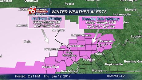
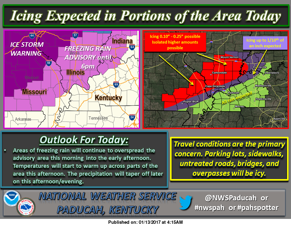
Here is a graphic for the amount of precipitation from the National Weather Service from Paducah KY:

friday the 13th weather chart #2

Here are the statements that are in effect for Franklin County from the National Weather Service in Paducah KY:

…FREEZING RAIN ADVISORY REMAINS IN EFFECT UNTIL 6 PM CST THIS EVENING… A FREEZING RAIN ADVISORY REMAINS IN EFFECT UNTIL 6 PM CST THIS EVENING. *

TIMING…THROUGH THE DAY TODAY.

* ICE ACCUMULATIONS…A GLAZE OF ONE TO TWO TENTHS OF AN INCH OF ICE LIKELY MOST AREAS. ACCUMULATIONS CLOSE TO ONE QUARTER OF AN INCH EXPECTED FROM MARBLE HILL TO JACKSON TO PERRYVILLE MISSOURI TO CARBONDALE AND PINCKNEYVILLE ILLINOIS.

* IMPACTS…TRAVEL IMPACTS EXPECTED…ESPECIALLY ON SECONDARY AND UNTREATED ROADS. SIDEWALKS AND PARKING LOTS MAY BE VERY SLICK IF NOT TREATED. VEHICLES WILL ICE OVER. SOME ICE ACCUMULATION ON POWER LINES IS EXPECTED.

PRECAUTIONARY/PREPAREDNESS ACTIONS… A FREEZING RAIN ADVISORY MEANS THAT LESS THAN ONE QUARTER INCH OF FREEZING RAIN OR FREEZING DRIZZLE WILL CAUSE HAZARDOUS TRAVEL CONDITIONS. BE PREPARED FOR SLIPPERY ROADS. SLOW DOWN AND USE CAUTION WHILE DRIVING.

THIS HAZARDOUS WEATHER OUTLOOK IS FOR PORTIONS OF SOUTHERN ILLINOIS, SOUTHWEST INDIANA, WESTERN KENTUCKY, AND SOUTHEAST MISSOURI.

.DAY ONE…TODAY AND TONIGHT A FREEZING RAIN ADVISORY IS IN EFFECT TODAY ALONG AND NORTHWEST OF A LINE FROM HENDERSON KENTUCKY TO POPLAR BLUFF MISSOURI…INCLUDING ALL OF SOUTHERN ILLINOIS UNTIL 600 PM.

ICE ACCUMULATIONS WILL BE HIGHEST FROM NORTH AND WEST OF A LINE FROM MARBLE HILL MISSOURI TO CARBONDALE ILLINOIS…WHERE UP TO ONE QUARTER INCH OF ICING IS POSSIBLE.  PLEASE REFER TO THE FREEZING RAIN ADVISORY FOR DETAILS. .

DAYS TWO THROUGH SEVEN…SATURDAY THROUGH THURSDAY SMALL CHANCES OF THUNDERSTORMS ARE POSSIBLE OVER ALL OR PART OF THE OUTLOOK AREA MONDAY THROUGH TUESDAY EVENING. NO WIDESPREAD SEVERE IS EXPECTED. LIGHTNING AND LOCALLY HEAVY DOWNPOURS WILL BE THE PRIMARY HAZARDS.

Here is a link to the seven day forecast for Franklin County

http://forecast.weather.gov/MapClick.php?map.x=176&map.y=89&site=pah&zmx=1&zmy=1#.WHjVkNQrJxA

We will keep everyone updated on road conditions and cancellations-

sd
 

Closings and cancellations 1/13/17

snow-dayI will use media sources to get every closing from I -64 south, since people go to this website all over Southern Illinois.  Please contact me with any closings by the following ways:

You can call or text me at 513-2516, call at 937-0253; PM me on Facebook (Steve Dunford), email me at sdunford1970@hotmail.com.

It will be nearly impossible to reply to individual requests if a school or business is closed.  I will update frequently with times.

Updated 6:30 am 1/13/17

I will lump all closings categorized by county.  Any type will be under the county listed.  

SCHOOLS-The only schools that I do not have in Southern Illinois are the following:  Century, The only Johnson County School I have is Lick Creek, Hardin County and Pope County.  

COLLEGES-  The only ones I have not heard anything about is Shawnee Community College and SIU, which never calls off.  The key staff needs to report at Morthland COllege.  

I am going to go to sporting events/business mode now.  

FRANKLIN COUNTY

Murphysboro at Benton Boys HS basketball/no make up date as of yet

Kids R My Business Day Care, Christopher

Girls Junior High Class L regional Benton/DuQuoin

JEFFERSON COUNTY

PERRY COUNTY 

UNION COUNTY

WASHINGTON COUNTY

Freezing Rain Advisory for Franklin County.

The National Weather Service in Paducah KY has issued a freezing rain advisory for all of Southern Illinois, except Randolph and Washington counties, which is under an Ice Storm Warning.

Ice storm warning

I am going to share two statements.  One is from the NWS in Paducah.  Randolph and Washington counties are under the jurisdiction of the NWS in St. Louis.  Sometimes that is why they have different advisories and warnings.

Here are both statements from each NWS office.

Here is the one from the Paducah office.

…FREEZING RAIN ADVISORY IN EFFECT FROM 3 AM TO 6 PM CST FRIDAY… THE NATIONAL WEATHER SERVICE IN PADUCAH HAS ISSUED A FREEZING RAIN ADVISORY…WHICH IS IN EFFECT FROM 3 AM TO 6 PM CST FRIDAY. *

TIMING…LATE TONIGHT THROUGH THE DAY ON FRIDAY. * ICE ACCUMULATIONS…A GLAZE OF ONE TO TWO TENTHS OF AN INCH OF ICE LIKELY MOST AREAS. ACCUMULATIONS CLOSE TO ONE QUARTER OF AN INCH EXPECTED FROM MARBLE HILL TO PERRYVILLE…CARBONDALE AND PINCKNEYVILLE. *

IMPACTS…TRAVEL IMPACTS EXPECTED…ESPECIALLY ON SECONDARY AND UNTREATED ROADS. SIDEWALKS AND PARKING LOTS MAY BE VERY SLICK IF NOT TREATED. VEHICLES WILL ICE OVER. PRECAUTIONARY/PREPAREDNESS ACTIONS…

A FREEZING RAIN ADVISORY MEANS THAT LESS THAN ONE QUARTER INCH OF FREEZING RAIN OR FREEZING DRIZZLE WILL CAUSE HAZARDOUS TRAVEL CONDITIONS. BE PREPARED FOR SLIPPERY ROADS. SLOW DOWN AND USE CAUTION WHILE DRIVING.

Here is the one from NWS in St. Louis

…ICE STORM WARNING IN EFFECT FROM 9 AM FRIDAY TO NOON CST SUNDAY… THE NATIONAL WEATHER SERVICE IN SAINT LOUIS HAS ISSUED AN ICE STORM WARNING…WHICH IS IN EFFECT FROM 9 AM FRIDAY TO NOON CST SUNDAY. THE WINTER STORM WATCH IS NO LONGER IN EFFECT. * TIMING…

FREEZING RAIN WILL OVERSPREAD THE AREA FRIDAY MORNING FROM SOUTH TO NORTH. SIGNIFICANT ICING IS EXPECTED TO OCCUR FROM FRIDAY MORNING THROUGH SUNDAY MORNING. * ACCUMULATIONS…ONE QUARTER TO THREE QUARTERS OF AN INCH OF ICE. *

TEMPERATURES…UPPER 20S TO LOWER 30S. * WINDS…NORTHEAST 5 TO 10 MPH. * IMPACTS…THE ICE WILL RESULT IN HAZARDOUS TRAVEL CONDITIONS…ESPECIALLY ON BRIDGES…OVERPASSES…AND UNTREATED ROADS. PARKING LOTS AND SIDEWALKS WILL BECOME SLIPPERY AS WELL. DAMAGE TO TREES AND POWER LINES IS ALSO POSSIBLE.

PRECAUTIONARY/PREPAREDNESS ACTIONS… AN ICE STORM WARNING MEANS THAT A SEVERE AND DANGEROUS AMOUNT OF ICE ACCUMULATION IS OCCURRING OR EXPECTED TO ACCUMULATE… ESPECIALLY ON UNTREATED SURFACES…SUCH AS SIDEWALKS… DRIVEWAYS…ROADS… AND PARKING LOTS. THE HEAVY ICE ACCUMULATIONS WILL MAKE TRAVEL DANGEROUS OR IMPOSSIBLE.

IF YOU MUST TRAVEL…EXERCISE EXTREME CAUTION…AND BEGIN YOUR TRAVEL WITH A FULL TANK OF GAS…AND CARRY A WINTER STORM KIT WHICH INCLUDES A SHOVEL…FLASHLIGHT…CELLPHONE…FOOD AND WATER…AND BLANKETS OF EXTRA WARM CLOTHING. ICE ACCUMULATIONS AND WINDS WILL LIKELY LEAD TO SNAPPED POWER LINES AND FALLING TREE BRANCHES THAT ADD TO THE DANGER. &&

I listened to Dave Murray on a live Facebook  feed from Fox 2 in St Louis.  Summarizing his words, he had Pinckneyville to Salem in the bulls-eye.  I included St. Louis in this for one reason, if you have to go up there for a medical appointment, please consider cancelling.

We will have up to the minute cancellations.  Thank you for your response.  There has been over 3,000 views. – sd

Today is the day to prepare if not already

I have spent the last hour or so looking over models trying to get a consensus of the approaching weather system.  It seems like the consensus is the system will be dryer, but more widespread.

As of now the charts have been implying this, but it looks like the northwest part of Franklin County will get the greatest amount of impact with .1″ to .3″ inches of ice expected.  The southeastern part of the county is expected to receive less that .1″ of ice.  The places in between will receive .1″ to .2″ inches of ice.

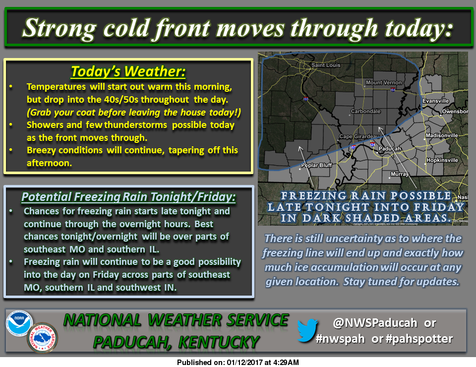
January 12 graphic

The freezing line and amount of precipitation that we receive we exactly do not know until it gets on top of us.   There is a strong chance we are going to get ice tomorrow.  Today is the time to prepare.

This is something that we will not be in for several days as of yet, it ought to be something that we should prepare for a Friday at home and some brief power outages.

It is 69 degrees as we speak.  Temperatures will be falling till around 40 by nightfall.  The low is supposed to be 29 this evening.  The changeover from rain to freezing rain will take place between 10 pm to 12 pm.

Here is the products that have been issued by the National Weather Service for Franklin County-

SPECIAL WEATHER STATEMENT…GUSTY WINDS TO CONTINUE THIS MORNING…FREEZING RAIN LIKELY FRIDAY…

Freezing rain appears likely Friday across portions of southeast Missouri, southern Illinois and southwest Indiana. The activity could develop into the area before daybreak. It is expected to increase Friday morning, and last through the afternoon and then taper off. Confidence continues to increase the freezing air will make it as far south as a Greenville Missouri, Marion Illinois, Princeton Indiana line.

There may be some impacts to travel, especially on bridges, overpasses, and secondary roads. Sidewalks and parking lots may become quite slick as well. Elevated surfaces will ice. Expect a glaze on automobiles. Impacts to power should be minimal.

Meanwhile this morning, southwest winds will gust from 25 to 35 mph at times. This will cause loose objects to blow around. Travel may be difficult for some high profile vehicles. A cold front will move through this morning and early afternoon from north to south across the area. Winds will shift to the northwest and decrease behind the front.

THIS HAZARDOUS WEATHER OUTLOOK IS FOR PORTIONS OF SOUTHERN ILLINOIS, SOUTHWEST INDIANA, WESTERN KENTUCKY, AND SOUTHEAST MISSOURI

. .DAY ONE…TODAY AND TONIGHT A FEW ISOLATED THUNDERSTORMS WILL BE POSSIBLE TODAY. WINDS WILL GUST 25 TO 35 MPH THIS MORNING.

FREEZING RAIN WILL BE POSSIBLE LATE TONIGHT AND INTO THE OVERNIGHT HOURS ACROSS PORTIONS OF SOUTHEAST MISSOURI AND SOUTHERN ILLINOIS

. .DAYS TWO THROUGH SEVEN…FRIDAY THROUGH WEDNESDAY FREEZING RAIN WILL CONTINUE TO BE A THREAT AS WE HEAD THROUGH THE DAY ON FRIDAY ACROSS PORTIONS OF SOUTHEAST MISSOURI, SOUTHERN ILLINOIS AND PARTS OF SOUTHWEST INDIANA. FREEZING RAIN IS POSSIBLE GENERALLY NORTH AND WEST OF A LINE FROM POPLAR BLUFF MISSOURI TO EVANSVILLE INDIANA. THE HIGHEST ICE ACCUMULATIONS ARE EXPECTED NORTH AND WEST OF A LINE FROM GREENVILLE MISSOURI TO CARBONDALE AND MOUNT VERNON IL.

THUNDERSTORMS ARE POSSIBLE ON MONDAY AND MONDAY NIGHT…THEN AGAIN TUESDAY NIGHT THROUGH WEDNESDAY MORNING. NO WIDESPREAD SEVERE WEATHER IS EXPECTED. LIGHTNING AND LOCALLY HEAVY DOWNPOURS WILL BE THE PRIMARY HAZARDS. THIS PROLONGED PERIOD OF OFF AND ON RAINFALL MAY RESULT IN STANDING WATER IN LOW LYING AND POOR DRAINAGE AREAS…ALONG WITH POSSIBLE RISES IN SMALL CREEKS AND STREAMS.

Here is a link to the seven day forecast in Franklin County:

orecast.weather.gov/MapClick.php?map.x=176&map.y=89&site=pah&zmx=1&zmy=1#.WHeC8NQrJxA

We will keep the social media page updated with new charts and graphs issued.  If there is an advisory or a Winter Storm Watch issued for Franklin County will put this on the website as well as an updated closing and cancellation thread if it warrants.


Obama calls on supporters to renew fight for liberal values in farewell address

USA Today photo

USA Today photo

In his farewell address to the nation Tuesday night, a tearful President Obama called on Americans to keep working toward income equality, racial healing and bipartisan cooperation — the same goals he was unable to achieve over the past eight years. With 10 days remaining in his presidency, Mr. Obama traveled to Chicago to deliver his valedictory speech to about 20,000 supporters and urge them to renew the fight for liberal values in the administration of Republican Donald Trump. “We must forge a new social compact,” Mr. Obama said. “If we don’t create opportunity for all people, the disaffection and division that has stalled our progress will only sharpen in years to come.” The president warned of threats facing democracy, saying race “remains a potent and often divisive force in our society.” Please click on the link to read the article from Dave Boyer of the Washington Times

Trump gives a press conference for the ages

(AP photo)

(AP photo)

President-Elect Donald Trump gave his first news conference since winning the election — and it was epic. If pundits and the Washington elite think Mr. Trump is going to change his tone or style going into the White House, they’re sorely mistaken. He’s a fighter. He’s accomplished too much in his life, overcome too many obstacles to bow down to anybody. Including the press. “No, I’m not going to give you an answer,” Mr. Trump told CNN’s Jim Acosta. “You are fake news.” The exchange came on the heels of an explosive CNN report that said the intelligence community presented a briefing to both President Obama and Mr. Trump “including allegations that Russian operatives claim to have compromising personal and financial information about Mr. Trump.” Except no one knows if that’s true — or has verified the contents of the report on which it was based. Please read the rest of the story from Kelly Ridell of the Washington Times…(This is an op-ed piece but it also gives the highlights of today)

Ice for late Thursday night and into Friday.

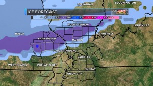
We are sitting on the fence on this in Franklin County.  Ice is very tricky to forecast.  Forecast models are very confident there will be significant icing northwest of us.  There will be a model below by KFVS-12 meteorologist Brian Alworth posted this morning on social media.  On his page.  It is noteworthy by here in Franklin County we are in the 1/4 to 1/2 inch of ice range.  However, the Southern Seven counties are expecting mostly rain.  Honestly, I think it is wise to be prepared for the worse case scenario.

Franklin County is in the quarter to a half inch range. (KFVS-TV Photo)

Franklin County is in the quarter to a half inch range. (KFVS-TV Photo)

Here is the quote from Alworth, “We are still studying the threat of freezing rain in the Heartland early Friday. This sort of system is difficult for forecast models to handle. We are expecting a very shallow layer of cold air to blow in from the north Thursday night into Friday morning…with surface air temps across our northern counties just below freezing. Meanwhile just a few hundred feet up we’ll still have warmer air…so that precip will fall as rain and freeze on contact especially on raised surfaces.”

“Models with greater resolution (more layers in the vertical) handle this sort of scenario better…and today we’ll start to get data from these shorter-term models.”

Here is the Hazardous Weather Outlook put out by the National Weather Service of Paducah KY for Franklin County,

.DAY ONE…TODAY AND TONIGHT A FEW ISOLATED THUNDERSTORMS WILL BE POSSIBLE TODAY AND TONIGHT.

.DAYS TWO THROUGH SEVEN…THURSDAY THROUGH TUESDAY ISOLATED THUNDERSTORMS ARE POSSIBLE ON THURSDAY. FREEZING RAIN AND A GLAZE OF ICE ARE POSSIBLE ACROSS PORTIONS OF SOUTHEAST MISSOURI…SOUTHERN ILLINOIS AND SOUTHWEST INDIANA FROM LATE THURSDAY NIGHT THROUGH EARLY FRIDAY EVENING. SIGNIFICANT RAINFALL AMOUNTS COULD OCCUR SATURDAY THROUGH TUESDAY.

HOWEVER…THE EVENT WILL BE SPREAD OUT OVER SEVERAL DAYS. THIS WILL LIKELY RESULT IN STANDING WATER IN LOW LYING AND POOR DRAINAGE AREAS…ALONG WITH POSSIBLE RISES IN SMALL CREEKS AND STREAMS.

Here is a link to the seven day forecast for Franklin County

http://forecast.weather.gov/MapClick.php?map.x=176&map.y=89&site=pah&zmx=1&zmy=1#.WHZePdQrJxA

This is a situation that needs to be taken serious.  We have not had the possibility of ice in the forecast like this in several years.  I think the “bread and milk” run might be warranted over the next few days.

The B meteorologist student in two whole classes can see anything happening.  If we receive half-inch of ice, and we are not going anywhere.  Make sure you have adequate supplies to survive without power for several hours.

Franklincountynews-com will keep releasing things from media sources on the Facebook page throughout the day.  When any watches are warnings is issued, we will post as a news story.

School-business closings will be updated frequently.


Main Street in WF Closed at the tracks

Union Pacific crews working on the railroad crossing on East Main Street in West Frankfort (Jeff Webb photo)

Union Pacific crews working on the railroad crossing on East Main Street in West Frankfort (Jeff Webb photo)

Union Pacific has completed the work on the crossing on South Main (Route 37) in Benton.  It has been open to traffic since yesterday afternoon.

Main Street in West Frankfort (Route 149) is now closed for repair of the railroad crossing.  It will be completed before 7:00 p.m. tomorrow evening, weather permitting.

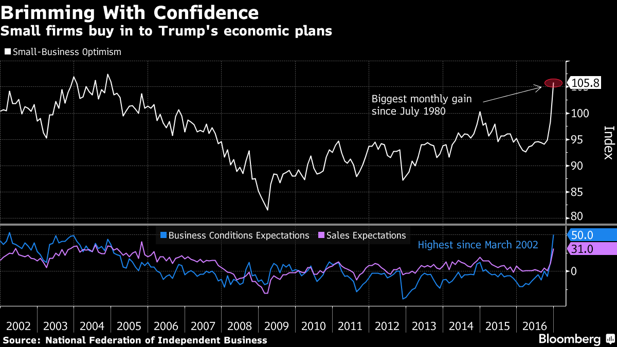
U.S. Small-Business Optimism Index Surges by Most Since 1980

grapth-1Optimism among America’s small businesses soared in December by the most since 1980 as expectations about the economy’s prospects improved dramatically in the aftermath of the presidential election. The National Federation of Independent Business’s index jumped 7.4 points last month to 105.8, the highest since the end of 2004, from 98.4. While seven of the 10 components increased in December, 73 percent of the monthly advance was due to more upbeat views about the outlook for sales and the economy, the Washington-based group said. The share of business owners who say now is a good time to expand is three times the average of the current expansion, according to the NFIB’s data. More companies also said they plan to increase investment and keep hiring, which reflects optimism surrounding President-elect Donald Trump’s plans of spurring the economy through deregulation, tax reform and infrastructure spending. Please click on the link to read the rest of the story from bloomberg.com

Jeff Sessions Rejects Charges He Holds Racist Views


Attorney General nominee Jeff Sessions in meetings with President Elect Donald Trump (Jerusalem Post photo)

Attorney General nominee Jeff Sessions in meetings with President Elect Donald Trump (Jerusalem Post photo)

Mr. Sessions, a Republican from Alabama, said he doesn’t support a ban on Muslims from entering the U.S., as Mr. Trump once proposed, and that the use of waterboarding was illegal under current law. The president-elect has advocated using that practice more frequently on terror suspects. The nominee also said he wouldn’t serve as a rubber stamp for the incoming administration and would recuse himself on any pending investigation into Mr. Trump’s opponent from the campaign, Democrat Hillary Clinton. “You have to say ‘no’ sometimes”…for the good of the country,” Mr. Sessions said at the start of the hearing, which is set to elevate one of the most conservative members of Congress to run the Justice Department. Please click on the link to read the rest of the story from The Wall Street Journal.

Benton, West Frankfort, Illinois News | Franklin County News