Benton Police blotter….

On 1/13/17 at approximately 10:00 p.m. Benton Police Officers reported to the 200 Block of S. Stotlar Street in reference to a narcotics investigation.  As a result of the investigation, Benton Officers, to include assistance from the Franklin County Sheriff’s Office K-9 Unit, searched the residence at which time Methamphetamine and Drug Paraphernalia was located. 37 year old Lola Swan  of Herrin, IL was charged with Unlawful Possession of Methamphetamine and 41 year old Curtis R. Key was charged with Unlawful Possession of Drug Paraphernalia.  Both were transported to the Franklin County Jail. Benton Police
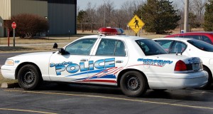
On 1/15/17 at approximately 1:00 a.m. a Benton Police Officer conducted a traffic stop on E. Main Street.  As a result  of the traffic stop investigation, the driver, 22 year old Denni J. Durbin of Benton was placed under arrest for Driving While License Suspended.   The officer also located Methamphetamine, Oxycodone, and hypodermic syringes in Durbin’s vehicle.  Durbin received additional charges of Unlawful Possession of Methamphetamine, Unlawful Possession of a Controlled Substance and Drug Paraphernalia.     Durbin was transported to the Franklin County Jail.
On 1/15/17 at approximately 11:00 p.m. a Benton Police Officer conducted a traffic stop on W. Main Street.  As a result of the traffic stop investigation, the driver, 28 year old Joshua P. Gray of Valier, IL was placed under arrest for Driving Under The Influence.  The officer also located items of drug paraphernalia during the stop which prompted an additional charge of Unlawful Possession of Drug Paraphernalia for Gray along with the passenger of the vehicle, 30 year old Rebecca L. Mueller of DuQuoin, IL.  Both were subsequently transported to the Franklin County Jail.

Wet and possibly stormy MLK day

Good Morning!!!!! We are off to a foggy start this morning.  A chance of showers and thunderstorms move in the area this afternoon and will continue in the overnight hours.  The high today is going to be in the upper 50’s, with a low around 50 degrees. MLK Weather chart

It is supposed to be mostly cloudy on Tuesday and we might get a peek of the sun on Wednesday, with highs in the lower 50’s and lows in the upper 30’s.

Rain chances are coming back in the forecast on Thursday into Friday.  Saturday is supposed to be very mild with highs in the mid 60’s, until a chance of rain enters on Sunday.

Here is a link to the seven day forecast for Franklin County.

http://forecast.weather.gov/MapClick.php?map.x=176&map.y=89&site=pah&zmx=1&zmy=1#.WHzPrdQrJxA


CIA director rips into Donald Trump over tweets, Russia

CIA BrennanOutgoing CIA Director John Brennan ripped into Donald Trump on Sunday for “talking and tweeting” about possibly easing sanctions against Russia, saying the president-elect lacks a full understanding of the threat Moscow poses to the United States. “I think he has to be mindful that he does not have a full appreciation and understanding of what the implications are of going down that road,” Brennan said on “Fox News Sunday,” a show Trump routinely watches. Vice President-elect Mike Pence, also in an appearance on “Fox News Sunday,” denied that Flynn and Kislyak discussed anything relating to the sanctions. Pence said he talked to Flynn about this Saturday. “The conversations that took place at that time were not in any way related to the new U.S. sanctions against Russia or the expulsion of diplomats.” Please click on the link to read the full story from the Chicago Tribune.

Statehouse Insider: Let’s chant: Two more years, two more years

MadiganSo much for the grand plan to oust MICHAEL MADIGAN as House speaker. Not that many people thought it was going to happen anyway, but there was a relentless drumbeat by the state Republican Party to shame Democrats into rejecting Madigan for another term as speaker. Democrats had already met privately during the veto session and decided to continue supporting Madigan, so last week’s public vote during the House swearing-in ceremonies was anticlimactic. The only dissenter, such as it was, was Rep. SCOTT DRURY of Highwood, who voted “present.” Almost immediately, the state GOP was back at it, banging their anti-Madigan drum and sending out emails criticizing Democrats who voted for him. The truly depressing thing about this is that this will now go on for another two years. It means there is another election cycle where it will be all “Madigan bad” all of the time. Please click to read the story from Doug Finke from the Springfield Journal-Register.

Trump skeptics should take heart in his cabinet nominees

Defense secretary appointee James "Mad Dog" Mattis in the center of President Elect Trump and VP Elect Pence (AP Photo)

Defense secretary appointee James “Mad Dog” Mattis in the center of President Elect Trump and VP Elect Pence (AP Photo)

Throughout their long — and at times pointed — confirmation hearings, Sen. Jeff Sessions (R-Ala.), former ExxonMobil chief executive Rex Tillerson and retired Marine Corps Gen. James Mattis comported themselves in a graceful and respectful way. They showed themselves to be thoughtful, patient and deliberate, and they retained a sense of humor and composure even in the face of marginalized protesters, tough questioning and pushback from cranky senators. It was a reassuring sight, especially when compared with the news conference President-elect Donald Trump held this week, which was acrimonious and at times outright belligerent, especially by White House news-conference standards. So how do we reconcile Trump’s often peevish, aggressive nature with the cool, calm and collected demeanor of three of his most vital Cabinet nominees? This opinion piece by Ed Rogers of the New York posts summarizes the three top level cabinet picks after senate conformations this week. Please click to read.

Ringling Bros. and Barnum & Bailey Circus to End Its 146-Year Run

cicusRingling Bros. and Barnum & Bailey circus announced on Saturday night that after 146 years of performances, it was folding its big tent forever. In a statement on the company’s website, Kenneth Feld, the chief executive of Feld Entertainment, the producer of Ringling, said the circus would hold its final performances in May. He cited declining ticket sales, which dropped even more drastically after elephants were phased out from the shows last year. “This, coupled with high operating costs, made the circus an unsustainable business for the company,” the statement said. “The circus and its people have continually been a source of inspiration and joy to my family and me.” Stephen Payne, a spokesman for Feld Entertainment, said in an interview on Saturday night that the closing would affect about 400 cast and crew members. Please click on the link to read the entire story from the New York Times

Only two more days left of yuck

January 15 weather graphic

Going to bed last night, it looked like there might have been a small chance of ice.  Those chances passed went northwest of us.  The rain will be hanging around off and on until Tuesday morning.

The rest of the week, temperatures will be in the mid 50’s, with it warming up into the 60’s by Friday.

If you read this on social media, hit like for today’s weather story being short and sweet for a change.

Here is a link to the seven day forecast for Franklin county.  It will be updated in real time when you click on it.

http://forecast.weather.gov/MapClick.php?x=183&y=91&site=pah&zmx=&zmy=&map_x=183&map_y=91#.WHt2hdQrJxA


Wave 2 of icy conditions passes through, but wave 3 could be most dangerous

St. Louis stormNote: Here is the bullet we dodged around here: ST. LOUIS • Periodic light rain glazed sidewalks and roads as a much-anticipated ice storm moved through the metro area. Slippery conditions contributed to one fatal crash. So far, ice amounts were less than advertised, although more is to come. “Overnight is the best chance for accumulation,” said Charley Kelly, a National Weather Service forecaster. “There are more waves of precipitation coming through.” A second wave of sleet and icy rain was expected to pass through the St. Louis region on Saturday morning, ending by about 10 a.m. Once that wave pushes through, temperatures should warm above freezing as conditions remain cloudy and drizzly.

Freezing Rain Advisory to our West -rain but warmer

It is going to be a wet one with highs in the 30’s today and tomorrow moderating up to the 50’s by mid-week.  A strange bright ball in the sky is forecasted for Wednesday, when it will finally clear off.  The high for Friday is supposed to be in the 60’s with a chance of storms.

A freezing rain advisory is in effect until noon for Jackson, Perry and Jefferson counties.  Please look at the graphic below:

Weather Advisiory

Here are the advisories from the NWS in Paducah including the Freezing Rain Advisory:


…FREEZING RAIN ADVISORY NOW IN EFFECT UNTIL NOON CST TODAY… THE FREEZING RAIN ADVISORY IS NOW IN EFFECT UNTIL NOON CST TODAY.

* TIMING: LIGHT ICING WILL CONTINUE TO BE POSSIBLE THROUGH THE MORNING HOURS.

* ICE ACCUMULATIONS: MOST ACCUMULATIONS WILL BE ON ELEVATED SURFACES. THE ICE WILL CONTINUE TO HAVE A MUCH MORE DIFFICULT TIME ACCUMULATING ON ROADS DUE TO SLIGHTLY WARMER SURFACE TEMPERATURES AND THE EXISTING ROAD TREATMENT IN SOME AREAS. AMOUNTS ON ELEVATED SURFACES WILL GENERALLY RANGE FROM A TRACE TO TWO TENTHS OF AN INCH WITH THE GREATEST AMOUNTS ALONG AND WEST OF A LINE FROM FROM GREENVILLE TO MARBLE HILL TO PERRYVILLE MISSOURI…AND FROM CARBONDALE TO MOUNT VERNON ILLINOIS.

IMPACTS: A FEW BACK ROADS…SIDE WALKS AND PARKING LOTS UNTREATED MAY BE SLICK AND HAZARDOUS.

HAZARDOUS WEATHER OUTLOOK

ICE ACCUMULATIONS ARE POSSIBLE THROUGH MID MORNING GENERALLY ALONG AND WEST OF A LINE FROM GREENVILLE MISSOURI TO MOUNT VERNON ILLINOIS. SEE THE FREEZING RAIN ADVISORY FOR ADDITIONAL DETAILS. AREAS OF DENSE FOG HAVE DEVELOPED OVER PARTS OF THE OUTLOOK AREA THIS MORNING. SEE THE DENSE FOG ADVISORY FOR ADDITIONAL DETAILS. .

DAYS TWO THROUGH SEVEN…SUNDAY THROUGH FRIDAY SMALL CHANCES OF THUNDERSTORMS ARE POSSIBLE OVER ALL OR PART OF THE OUTLOOK AREA FROM MONDAY AFTERNOON THROUGH TUESDAY AFTERNOON. NO WIDESPREAD SEVERE IS EXPECTED. LIGHTNING AND LOCALLY HEAVY DOWNPOURS WILL BE THE PRIMARY HAZARDS. .

Here is the seven day forecast for Franklin County:

http://forecast.weather.gov/MapClick.php?map.x=176&map.y=89&site=pah&zmx=1&zmy=1#.WHpH9tQrJxB


WSIL stories will be shared on the Facebook page

wsil news 3I want to make this an educational post.  Channel 3 is doing an excellent job covering Franklin County.

Any story about Franklin County, I share on the Facebook page, including highlights on Sports Extra.

The posts have been really successful.  There are several stories I am going to share on social media after 10pm.

I would like to thank you all for the overwhelming support and growth over the last two months.  This online paper belongs to you.

Benton, West Frankfort, Illinois News | Franklin County News