Spring conditions continue, along with the Severe Weather threat for tomorrow

nws friday severe

It is another spring like day with highs going to be in the lower 70’s and the low will be around 60 degrees.

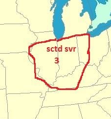
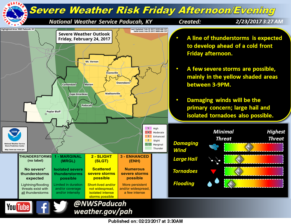
Tomorrow is when things start to get interesting.  As it has been in the forecast for three days there is a slight risk of severe weather for everything east of I 57.  (See graphic above)

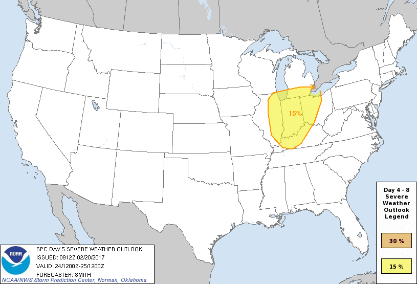
Here is today’s Hazardous Weather Outlook form the National Weather Service from Paducah KY

A chance of thunderstorms exists Friday afternoon and evening ahead of a cold front. This includes a slight risk of severe storms, mainly over southwest Indiana and the Pennyrile of western Kentucky. Damaging winds will be the primary severe weather hazard, but large hail and isolated tornadoes will also be potential hazards.

Tomorrow will be a situation that you need to keep abreast of with your favorite local media source.  The Facebook page will be updated frequently, as well as the website as much as possible.

The weekend will be much cooler with highs in the 40’s.  A warming trend will take place early next week, with a chance of showers and Thunderstorms on Tuesday.


Trump lifts Obama-era directive on transgender bathrooms

WASHINGTON, DC (Bradford Richardson- The Washington Times. Please click on the link to read the full story. Here is an excerpt) The Trump administration revoked an Obama-era mandate compelling public schools nationwide to permit restroom and locker room access on the basis of gender identity — a move that could have significant ramifications for a case before the Supreme Court concerning transgender rights. The Departments of Education and Justice issued a joint guidance Wednesday evening rolling back the order. The two-page “Dear Colleague Letter” said the Obama administration had failed to substantiate the claim that Title IX’s prohibition on “sex” discrimination in education also applies to gender identity.

MVTHS reverses decision on Creel

The Centralia student section in last Friday night's game against Mt. Vernon, wearing shirts in support of MVTHS coach and AD, Doug Creel (Randy Olson photo)

The Centralia student section in last Friday night’s game against Mt. Vernon, wearing shirts in support of MVTHS coach and AD, Doug Creel (Randy Olson photo)

MT. VERNON, IL – (Travis Morse – Mt. Vernon Register-News – Please click on the link to read the full article. Here is an excerpt) The Mt. Vernon Township High School Board of Education Tuesday voted to return the athletic director position to the administrative team for next school year. This reverses the board’s controversial decision last month to make the position non-administrative, an action that provoked a wave of criticism from supporters of Athletic Director Doug Creel. “In our opinion, the vote that was taken at the January meeting which eliminated Doug’s administrative position was taken without accurate information provided to the board,” said concerned citizen Randy Olson, who has led a social media campaign against the MVTHS administration. “We believe that Mt. Vernon Township High School is fortunate to have Mr. Creel as a coach, as an athletic director, and as administrator.”

Preparing for dark times: Total solar eclipse arrives 6 months from today

A solar eclipse over Indonesia in March, 2016.  (AP file photo)

A solar eclipse over Indonesia in March, 2016. (AP file photo)

ST. LOUIS, MO – (Valerie Schremp Hawn – St. Louis Post Dispatch- Click on the following link for the full story. Here is an excerpt. If you haven’t already, you might want to mark your calendars for six months from today, and make a special notation for oh, say, early afternoon, depending on your location. You’re in for one of the darker, stranger experiences of your life on this planet. A total solar eclipse — the first one in the continental United States since 1979, and the first one for most of the St. Louis area since 1442 — arrives on Monday, Aug. 21. The partial eclipse will start in late morning and end in early afternoon, with the total eclipse within the 1 p.m. hour. You may or may not have heard about the eclipse already — but folks at the Bloomsdale bank in Herculaneum and their City Hall have. They’re selling viewer glasses for $1. Southern Illinois University Carbondale will celebrate with a weekend of events to culminate in a public viewing at Saluki Stadium. & Even Ozzy Osbourne, the Prince of Darkness, is in on the eclipse action: He’s performing at a “Moonstock” music festival in Carterville, IL.

Showers and Cloudy this afternoon- severe thunderstorms still in forecast for Friday

Today it will be partly cloudy with on and off showers existing until evening with a high in the upper 60’s and lows will be in the upper 40’s

Tomorrow and Thursday will be gorgeous, with highs in the lower 70’s and lows in the lower 50’s.

There will be one round of storms roll in late Thursday night and another around Friday afternoon.  The severity at this point is to far out to determine.

TORCON for the region on Friday- Dr. Greg Forbes - The Weather Channel.

TORCON for the region on Friday- Dr. Greg Forbes – The Weather Channel.

The TORCON from Dr. Greg Forbes of the Weather Channel. is a 3 for the region on Friday.  This means there is a 30% of a tornadic event 50 miles from the region.

This does not mean that there will be a destructive tornado, it means there is that chance of going under a Tornado Warning because of rotation.

It will be much cooler for the duration, with highs in the upper 40’s on Saturday, moderating to the mid 50’s on Tuesday.


New form of heroin behind several overdoses in southern IL

PinkyMARION, IL – (Brittany Jacob – KFVS -TV Click on the link to read the full story and view the video. Here is an except) MARION, IL (KFVS) – There is a new drug that has Illinois lawmakers taking action. They call it U4 and lawmakers classified it as a Schedule 1 controlled substance. Some even call it “pinky” for its pink hue. However, this has yet to stop the number of overdoses in southern Illinois. Most people are familiar with opioids such as morphine or codeine used for medicinal purposes, but there’s also heroin. “Heroine is actually very large and common drug around here,” Michael Chipma, ER director, said. “It has become cheaper. People are getting more access to it. Unfortunately, it is getting stronger and killing people.” The new drug, U4, is a lot stronger.

West Frankfort prepares for new businesses

Site of the new Taco Bell restaurant being built by the VF mall in West Frankfort (Evie Allen-WSIL-TV photo)

Site of the new Taco Bell restaurant being built by the VF mall in West Frankfort (WSIL-TV photo)

WEST FRANKFORT, IL- (Evie Allen -WSIL TV. Please click for the read the entire story and accompanied video. Here is an excerpt) City leaders in West Frankfort have made a big investment in their town. They’ve signed papers to purchase almost 20 acres of land north of the mall. The deal to buy the land had been in the works for the past four months. Mayor Tom Jordan says he hopes to make it a destination spot for drivers along the interstate. “It kind of fits into the whole picture out here of what we’re trying to accomplish,” says Jordan. This Spring, West Frankfort will offer a new restaurant Taco Bell. It makes up just one part of Jordan’s plan for growth. The sale of the Taco Bell property allowed the city to purchase 17 1/2 more acres nearby, for more business development.

Awesome week ahead-severe weather possible on Friday

day5prob

It is going to be sunny today with a high temperature in the lower 70’s

Tonight there is a 70% chance of showers and thunderstorms after midnight with the lows in the middle 50’s

Tomorrow there is a 40% chance of rain with highs in the upper 60’s, lows in the upper 40’s

Wednesday and Thursday will be partly sunny with highs in the lower 70’s lows in the mid to upper 50’s.

Friday might be interesting around here.  The Storm Prediction Center has everything basically east of I 57 in a fifteen percent chance of seeing severe weather.  I know that sounds low, but it is equivalent for being under a slight risk.  (See graphic above)

When the SPC has an area highlighted five days in advance, the confidence is pretty high.

Here is the hazardous weather outlook from the National Weather Service in Paducah, KY

.DAY ONE…Today and Tonight A small chance of thunderstorms will spread eastward across southeast Missouri into southern Illinois and the Purchase Area of west Kentucky tonight, mainly after midnight. A brief heavy downpour and a few lightning strikes will be the primary concerns. .

DAYS TWO THROUGH SEVEN…Tuesday through Sunday Chances of thunderstorms are forecast for all or a portion of the region Thursday afternoon through Friday. The best chances will be east of the Mississippi River Friday afternoon, when a few severe storms with damaging winds cannot be ruled out. Otherwise, locally heavy rainfall and lightning will be the primary concerns.

It will be much cooler for the weekend with highs in the upper 40’s to lower 50’s.

There will be more information to pass along to you on Friday.


Have a need for speed? Proposed Illinois law may grant you that wish

speed limit 75#2SPRINGFIELD, IL (Don O’Brien Belleville News-Democrat, Click on the link to read the full story. Here is an excerpt) Those who would like to drive a little faster on Illinois interstates and highways soon may get their wish. State Sen. Jim Oberweis (R-North Aurora) introduced a bill earlier this month that would push the speed limit to 75 mph on many of the state’s interstates as well as make 60 the maxium speed limit on rural highways. Oberweis was one of the driving factors behind a bill that helped Illinois become the 37th state to push its speed limit to 70 when that law took effect on Jan. 1, 2014. Now, he’s looking to bump that maximum speed up a bit. 

Lake Oroville levels fall as work continues at emergency spillway

Water gushes over the emergency spillway of Oroville dam.  With heavy rains approaching, the threat of failure still remains.  (AP file photo)

Water gushes over the emergency spillway of Oroville dam. With heavy rains approaching, the threat of failure still remains. (AP file photo)

OROVILLE, CA – (Andre Byik -Oroville Mercury-Register Please click on this link to read the following stories and to keep updated on this story from Oroville’s local newspaper. Here is an excerpt.)  The surface water elevation at Lake Oroville continued to drop Sunday morning, nearing a goal of 850 feet previously set by the California Department of Water Resources despite a bout of wet weather that has flooded highways and roads throughout the north state. As of 1 p.m. Sunday, the elevation of the reservoir was 852 feet, which was down about 49 feet when water began flowing over the emergency spillway at Oroville Dam Feb. 11. Water releases down the damaged main spillway were measured at 55,000 cubic-feet per second, with inflow into the lake measured at 28,000 cfs. Officials expected outflows to outpace inflows Sunday, and the reduction in flows down the main spillway has allowed crews to view debris buildup and dredge debris piles below the chute.

Benton, West Frankfort, Illinois News | Franklin County News