Morthland college receives minor water damage…eclipses goal for their library.

by Steve Dunford

From this past weekends heavy rains, Morthland College received some damage to their campus this weekend.  I spoke to Leigh Caldwell, who wears many hats for Morthland, and she said,  “We have some water damage at Coleman Rhoads Hall, in the area that houses a handful of student services employees. They are being temporarily relocated. None of our classes are affected.”

This resulted in the postponement of the book sale at the school.

Here is some good news. The campus set a lofty goal for enhancing their library.  The following statement was on their Facebook page:

Morthland college photo

Morthland college photo

If you hear Alpharetta chime 50 times on the morning of 5.1, don’t be alarmed; we’re just #forgingon.  The Hall Snyder Library is officially at 50,082 books. Our campus goal of 50k by May has been reached!

We’ve got a bit of a problem, though. Our library stacks are quite literally in stacks on the floor! Help us finish raising the funds by the end of month fuve to build 15 more shelves.

Morthland College is a Chirstian based, non-denominational, liberal arts Chirstian college in West Frankfort.  They offer a wide range of programs including athletics.   Through their guilds, they have provided many jobs to the people of Franklin and surrounding counties.


Flood warning extended until 5:45 P.M. 1″-3″ more inches of rain midweek

by Steve Dunford 

Potential for heavy rain

The Flood Warning for Franklin County has been extended until 5:45 this evening.   The warning text will be included in the bottom of this post. There are several road closures in the county still.  This has been posted on the website and the Facebook page.

Starting Tuesday night into the overnight hours on Friday Morning there are chances of rain.  During this period, it is forecast that we will receive an additional 1-3 inches of rainfall.  (see graphic above)

rndi2_hg

The water at Rend Lake is clearing the entire spillway, and not just the notch in the middle. (see graphic above)  The water will do this at 410 feet. There is also a Lake Wind advisory for all of Southern Illinois. (advisory text below)

I will provide an update on facility closures.  South Sandusky boat ramp is schedued to close sometime this evening.


plmi2_hg (1)

The Big Muddy at Plumfield is set to crest today at 28 feet in the moderate flood stage range.  I spoke with Mary Lamm, Project Hydrologist at the National Weather Service in Paducah KY, and asked about the Big Muddy River and if the water released from Rend Lake will read on the automatic gauge there.

In our conversation she said that the gauge does compensate for it.  She said that Rend Lake will affect the recession of the water that far down stream, but not add to the rise of it.  River stage forecasts will include the additional rainfall projected starting tomorrow.

In some regional stages the Mississippi will crest in Chester at 43.5 feet on Thursday, which puts it in major flood stage.  Several media outlets are sharing concern that the bridge will be closed there.  There is only one lane open on the Missouri side. At Cape Girardeau  the river will crest at 48.5 feet one-tenth above the record.  It will also crest in Thebes on Saturday at 47 feet a few tenths below the record.  All points on the Ohio, including Cairo are in moderate flood stage.

Here are the warnings and statements issued by the National Weather Service in Paducah KY.

FLOOD WARNING 

The National Weather Service in Paducah has issued a * Flood Warning for… Perry County in south central Illinois… White County in southeastern Illinois… Wayne County in south central Illinois… Wabash County in southeastern Illinois… Jefferson County in south central Illinois… Edwards County in southeastern Illinois… Williamson County in southern Illinois… Saline County in southern Illinois… Jackson County in southern Illinois… Franklin County in south central Illinois… Hamilton County in south central Illinois… * Until 545 PM CDT Monday *

At 544 AM CDT, flooding continued in many areas. The threat for heavy rainfall is over. However, flooding along rivers, creeks and streams will continue, along with numerous water covered, flooded roads. There should be improvement in some areas. * Some locations that will experience flooding include… Carbondale, Marion, Mount Vernon, Herrin, Harrisburg, West Frankfort, Murphysboro, Mount Carmel, Benton, Du Quoin, Pinckneyville, Carterville, Carmi, Fairfield, Eldorado, Johnston City, McLeansboro, Christopher, Albion and Rend Lake Area.

PRECAUTIONARY/PREPAREDNESS ACTIONS… Turn around, don`t drown when encountering flooded roads. Most flood deaths occur in vehicles. Excessive runoff from heavy rainfall will cause flooding of small creeks and streams, country roads, farmland, and other low lying spots.

FLOOD WARNING FOR THE BIG MUDDY

…The flood warning continues for the following rivers in Illinois… Big Muddy River near Plumfield and Murphysboro .

The Big Muddy river at Plumfield is expected to crest this evening at 28.0 feet. It will start falling after that and should fall below flood stage on Saturday morning.

On the Big Muddy at Murphysboro… heavy rainfall…combined with backwater from the Misssissippi River… will continue to cause a rise this week. It will crest at 40 feet on Thursday…which puts us in the major flood category.

PRECAUTIONARY/PREPAREDNESS ACTIONS… SAFETY MESSAGE… Never drive cars…trucks or sport utility vehicles through flooded areas. The water may be too deep to allow safe passage. Never allow children to play in or near flood waters. Stay tuned to NOAA Weather Radio or your local media for further statements and possible updated forecasts.

HAZARDOUS WEATHER OUTLOOK

This Hazardous Weather Outlook is for portions of southern Illinois, southwest Indiana, western Kentucky, and southeast Missouri. .

DAY ONE…Today and Tonight Following the weekend heavy rainfall, flooding continues in parts of our region, mainly southeast Missouri and southern Illinois. Major to record flooding exists on smaller rivers in southeast Missouri and southern Illinois. Please check the latest flood statements and warnings for details. Gusty southwest winds from 15 to 25 mph are expected today, with gusts up to 35 mph this afternoon. A Lake Wind Advisory is in effect for today.

.DAYS TWO THROUGH SEVEN…Tuesday through Sunday River flooding will continue through next weekend. Some of the larger mainstream rivers such as the Mississippi River will rise throughout the week. Some of the smaller rivers will begin to recede Tuesday. Please check river flood statements. A chance of thunderstorms is forecast for all or a portion of the area Wednesday and Thursday. Lightning and locally heavy rainfall will be the primary concerns. Rainfall well over an inch from Wednesday through Thursday may aggravate existing flooding or lead to new flooding, especially over southern Illinois and southwest Indiana.

LAKE WIND ADVISORY 

.Strong gusty southwest winds are expected today. These winds will be associated with the low pressure system that brought heavy rain and flooding to our region over the weekend.

The National Weather Service in Paducah has issued a Lake Wind Advisory, which is in effect from 7 AM this morning to 8 PM CDT this evening.

* TIMING…The strongest winds will occur from the late morning through the afternoon hours.

* WINDS…Southwest winds will increase to around 15 mph by mid- morning, then 20 to 25 mph for a few hours this afternoon. Gusts from 30 to 35 mph are likely this afternoon. Winds will decrease around sunset.

* IMPACTS…The strong gusty winds will pose a hazard to small boat operators on area lakes and rivers. Flood recovery efforts will also be negatively impacted, especially where boats are needed for checking flooded property.

PRECAUTIONARY/PREPAREDNESS ACTIONS… A Lake Wind Advisory indicates that winds will cause rough chop on area lakes. Small boats will be especially prone to capsizing.


The most recent list of road closures by Franklin County EMA

This is the latest updated list of road closures from Franklin County Emergency Management Agency.  Franklin County EMA has set up the Flood Response and Resource Information Center.  The link to the website is http://www.franklincountyil.gov/flooding.

Below is the list of road closings in the county by FCEMA updated at 1:00 A.M., Monday, May 1st.

Reported Flooded /Closed Roadways

If you observe water over a roadway DO NOT ATTEMPT TO CROSS. Report a flooded roadway by calling the Franklin County Communications Center at 618-438-4841. Remember, TURN AROUND, DON’T DROWN!

Reported by Central Dispatch Communications Center
Washington Street – West of Harrison Cemetary
Reported by West Frankfort Communications Center
500-600 Blocks of N Monroe Street
Street Louis- N on Douglas to 7th
100 Block North Joiner
600 Block North Parkhill
206 N. Parkhill
Locust Street
4th Street
5th Street
7th Street
9th Street
Ida st
Horrell Ave
Franklin County Sheriff’s Office – Communications Center
Valier Lake Road – East of 148
Yellowbanks Road at Big Muddy Bridge
Deering Road
Logan Road
Oak Rd, Royalton
Peach Orchard Road
Park Street (Perry County Side)
Mulkeytown Road
Hyde Park Road
Number 9 Blktop
Baseline Rd
State Highway 37 North of WF
Old Marion Rd
Woody Rd
Old JC Rd
Horseshoe Rd / Freeman Spur Rd
Akin Blktp / Bessie
Rome Road
Horseshoe Road
Franklin Ave off Orient Road


Flood warning for all of Southern Illinois until 5:45 a.m.

by Steve Dunford

The flash flood threat is over.  The National Weather Service in Paducah has issued a Flood Warning for all of Southern Illinois until 5:45 a.m. Monday Morning.

The difference between a Flash Flood Warning and a Flood Warning, a Flash Flood Warning is issued for an event that run off will be fairly quick.  A Flood Warning is issued when there is sustained water.  They are usually issued for rivers that are above flood stage.  Issuing one for a widespread area, is unprecedented.

I am going to show a couple graphics, and at the end include the warning text.  The first is the Big Muddy at Plumfield.

Big Muddy April 30


As you can see the Big Muddy has risen twelve feet over the last 48 hours.  It should crest in the night and slowly recede below flood stage toward the end of the week.   The NWS has severe flooding in the forecast for Murphysboro downstream, and possible record flooding might occur along the Mississippi at Cape.

I will keep a close eye on this for two reasons.  First Rend Lake is getting ready to release a lot of water.  Second there is 1-2 more inches of rain in the forecast from Tuesday night into Wednesday.

Here is a graphic for the headwaters at Rend Lake. Rend Lake 4-30

I spoke to a representative from  the Army Corps of Engineers on Friday and they said that at 410′ water will go over the entire spillway.  I will keep in contact with them for possible closure of facilities, and possible flooding on Rend City road.  If water will go over the auxiliary spillway, Rend Lake Dam road might close.

Here is the full text for the Flood Warning:


The National Weather Service in Paducah has issued a * Flood Warning for… Perry County in south central Illinois… White County in southeastern Illinois… Wayne County in south central Illinois… Wabash County in southeastern Illinois… Jefferson County in south central Illinois… Edwards County in southeastern Illinois… Williamson County in southern Illinois… Saline County in southern Illinois… Jackson County in southern Illinois…

FRANKLIN COUNTY IN SOUTH CENTRAL ILLINOIS. Hamilton County in south central Illinois… * Until 545 AM CDT Monday * At 538 PM CDT, flooding continued in many areas. The threat for heavy rainfall is over. However, flooding along rivers, creeks and streams will continue, along with numerous water covered, flooded roads. The dangers will increase tonight as the dangers of flooding become harder to recognize. * Some locations that will experience flooding include… Carbondale, Marion, Mount Vernon, Herrin, Harrisburg, West Frankfort, Murphysboro, Mount Carmel, Benton, Du Quoin, Pinckneyville, Carterville, Carmi, Fairfield, Eldorado, Johnston City, McLeansboro, Christopher, Albion and Rend Lake Area.

PRECAUTIONARY/PREPAREDNESS ACTIONS… Turn around, don`t drown when encountering flooded roads. Most flood deaths occur in vehicles. Be especially cautious at night when it is harder to recognize the dangers of flooding. Excessive runoff from heavy rainfall will cause flooding of small creeks and streams, country roads, farmland, and other low lying spots.


National Weather Service Extending Flash Flood Warning until 5:45 p.m.

Flash Flooding graphicThe National Weather Service in Paducah Kentucky is extending the Flash Flood Warning for Franklin and Several Surrounding counties until 5:45 P.M.  Here is the Warning text below.

/ BULLETIN – EAS ACTIVATION REQUESTED Flash Flood Warning National Weather Service Paducah KY 1225 PM CDT SUN APR 30 2017

The National Weather Service in Paducah has extended the * Flash Flood Warning for… Southern Perry County in south central Illinois… Union County in southern Illinois… Northern Johnson County in southern Illinois… Williamson County in southern Illinois… Saline County in southern Illinois… Jackson County in southern Illinois… North central Alexander County in southern Illinois… Franklin County in south central Illinois… Hamilton County in south central Illinois… East central Cape Girardeau County in southeastern Missouri… * Until 545 PM CDT *

At 1222 PM CDT, trained weather spotters reported upwards to 4 inches across portions of the warned area had already fallen. Spotters also reported creeks and streams still at or above bankfull in some locations, with numerous reports of flooded roadways still ongoing. Given continuing rainfall, and a threat of heavy rain still forecast, the flash flood warning has been extended through the remainder of the afternoon into the early evening hours. * Some locations that will experience flooding include… Carbondale, Marion, Herrin, Harrisburg, West Frankfort, Murphysboro, Benton, Du Quoin, Pinckneyville, Carterville, Anna, Eldorado, Johnston City, McLeansboro, Christopher, Jonesboro, Rend Lake Area, Sesser, Zeigler and Carrier Mills.

PRECAUTIONARY/PREPAREDNESS ACTIONS… Turn around, don`t drown when encountering flooded roads. Most flood deaths occur in vehicles. &&

A more comprehensive list of road closures-Franklin Co. EMA

per Franklin County Emergency Management Agency

For any information about flooding situation in the county, Please visit FCEMA’s online resource center at the following link:  http://www.franklincountyil.gov/flooding

Here is a list of the road closures in the county Emergency Management has posted:

Central Dispatch (West Side of Franklin County)
Oak Street in Zeigler
Washington St West of Harrison Cemetary
West Frankfort Dispatch Center
500- 600 Blocks of N Monroe
St Louis- N on Douglas to 7th
100 N Joiner
600 Block Parkhill
206 N Parkhill
Locust
4th
5th
7th
9th
13th to Herrin
Ida st
Horrell
Deering
Logan Road
Franklin County Sheriff’s Office
Oak Rd, Royalton
Peach Orchard
Mulkeytown Rd
Hyde Park Rd
Number 9 Blktop
Baseline Rd
State Highway 37 North of WF
Logan Rd
Old Marion Rd
Woody Rd
Old JC Rd
Horseshoe Rd/ Freeman Spur Rd
Akin Blktp/ Bessie


Update on the flooding situation

by Steve Dunford 

Severe weather risk 430
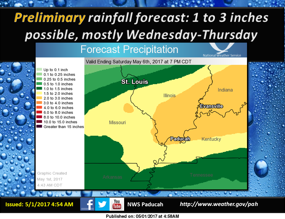
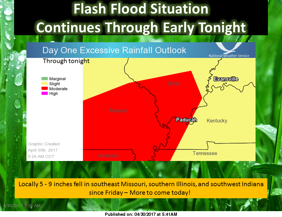
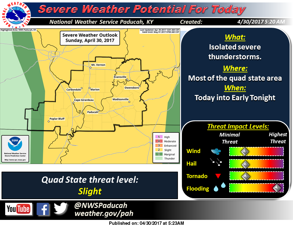
Here in Franklin County we will still be under a flash flood warning until 12:45 p.m. this afternoon.  That is likely to be extended.  We are supposed to get an additional 1″-3″ inches of rain on top of the 10+ inches we have received already.

As of now here are the road closures that I have:

  • Route 37 Between Benton and West Frankfort
  • Route 37 South of West Frankfort is now OPEN
  • Logan Road
  • Deering Road
  • Baseline Road has several washout places in addition to over the road.
  • Peach Orchard Road
  • There is water on Park Street Road and Yellowbanks Road but it is still open
  • Country Club road has opened up
  • The city streets in West Frankfort are in better shape than yesterday.  There is still flooding in the NW flood plain, but not as severe.

Any of the rural township roads that are over especially if it is a bridge, please do not attempt to cross as the bridge or the road could be washed out.

There is a slight risk for severe weather today for all of Southern Illinois for hail, damaging winds and isolated tornadoes.

The Big Muddy is experiencing moderate flooding.  The river is still supposed to crest on Tuesday below 28 feet, eight feet above flood stage.  The pool at Rend Lake is just under 409.  At 410 is when flooding begins.

Please pass along any additional information that you might have.  There will be updates throughout the day, especially on the franklincounty-news.com Facebook page.

Blessing of the bikes still on

by Steve Dunford 

2016 Blessing of the Bikes (from Bald Knob Cross Facebook page)

2016 Blessing of the Bikes (from Bald Knob Cross Facebook page)

ALTO PASS, IL-  The 25th annual Blessing of the Bikes will be tomorrow at Bald Knob cross, rain or shine.

Shad Zimbro, owner of Black Diamond Harley Davidson in Marion says the dealership will open at 8AM.  They will have breakfast there, and everyone will be leaving for Union County at 9:30

I will keep you informed if there is a change of schedule.


SEVERE THUNDERSTORM WATCH UNTIL 10:00 P.M.

ww0174_overview
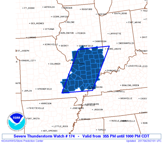
URGENT – IMMEDIATE BROADCAST REQUESTED Severe Thunderstorm Watch Number 174 NWS Storm Prediction Center Norman OK 355 PM CDT Sat Apr 29 2017

The NWS Storm Prediction Center has issued a * Severe Thunderstorm Watch for portions of Southern Illinois Extreme Western Kentucky Southeast Missouri * Effective this Saturday afternoon and evening from 355 PM until 1000 PM CDT. * Primary threats include… Scattered damaging wind gusts to 70 mph possible Scattered large hail events to 1.5 inches in diameter possible A tornado or two possible

SUMMARY…A line of storms is bowing eastward across east-central and southeast Missouri toward southern Illinois. It will pose a threat for damaging wind and possible hail as moves along and south of a warm front through the later afternoon and evening. The severe thunderstorm watch area is approximately along and 70 statute miles east and west of a line from 10 miles north of Mattoon IL to 35 miles southwest of Cape Girardeau MO.

PRECAUTIONARY/PREPAREDNESS ACTIONS… REMEMBER…A Severe Thunderstorm Watch means conditions are favorable for severe thunderstorms in and close to the watch area. Persons in these areas should be on the lookout for threatening weather conditions and listen for later statements and possible warnings. Severe thunderstorms can and occasionally do produce tornadoes.

Update on an already wild weather weekend

by Steve Dunford 

April 29th Day 1
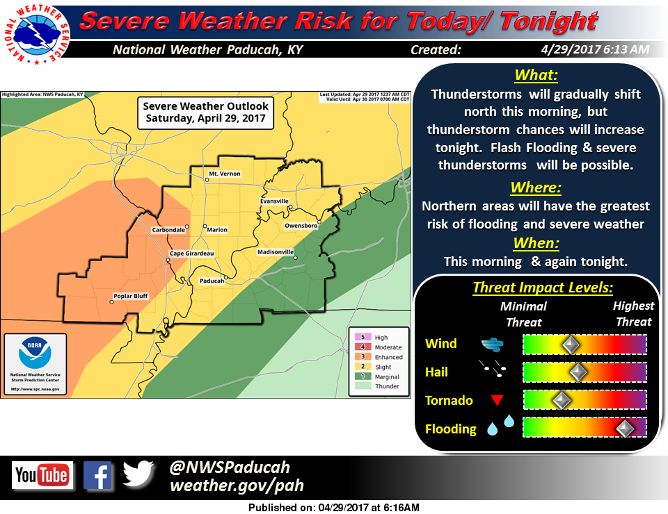
There was widespread flooding across Southern Illinois including the southern part of Franklin County.  Please see the recent story that I just completed about it.

We could see a repeat of last night through the overnight hours tonight, with a risk of severe thunderstorms in the afternoon and evening.

We have a break in the action as the warm front that prompted the several inches of ran last night, is draped along I 70 according to where the precipitation is currently on radar.  The Cardinal game has been rained out this afternoon.

If the cloud cover lifts, temperatures will like bounce up into the low to mid 80’s, and it will be very humid.  This would provide fuel for pop up thunderstorms this afternoon and also juice the atmosphere and increase the severe thereat for tonight.

We are under a slight risk of severe weather from now until late Sunday night.  On Sunday, there is the potential of a squall line forming in advance of an approaching cold front.

I will be away for a few hours this evening and I might not have internet access. Please follow your local media outlets for issuance weather statements.

Thank you all for the kind comments I have received over the last month and the ones that have encouraged me to share my take and opinion during severe weather events. I am not a meteorologist.  I have only six credit hours of meteorology in college that I took as an elective.  I have attended several seminars over the years, and I will continue training in this area.

The lake stage at Rend Lake is at 407.64.’  Which is nearly two feet over normal.  The lake level to start to be concerned about is 410′.  The lighter amount of rainfall helped flooding concerns overnight.

The Big Muddy River at Plumfield is at 16.66′. three feet over yesterday.  It should hit flood stage at 20′ overnight.  It is scheduled to crest at 27.8 feet sometime on Tuesday.  Moderate flooding should take place.  I would advise everyone to keep a close eye on this, especially if we get more heavy rain tonight.

Here are the statements issued by the National Weather Service in Paducah KY, pertaining to Franklin County.

Flood Warning National Weather Service Paducah  CDT SAT APR 29 2017  /

Perry IL-Williamson IL-Saline IL-Jackson IL-Franklin IL-Hamilton IL- Bollinger MO-Perry MO-Cape Girardeau MO- 843 AM CDT SAT APR 29 2017 The National Weather Service in Paducah has issued a * Flood Warning for… Perry County in south central Illinois… Williamson County in southern Illinois… Saline County in southern Illinois… Jackson County in southern Illinois… Franklin County in south central Illinois… Hamilton County in south central Illinois… Northeastern Bollinger County in southeastern Missouri… Perry County in southeastern Missouri… Northern Cape Girardeau County in southeastern Missouri… * Until 230 PM CDT *

At 835 AM CDT, emergency management reported flooding in parts of the warned area. Numerous roads were flooded or closed, especially in the Marion area of southern Illinois. Some water rescues were conducted early this morning. Rainfall amounts of 4 to 6 inches have been common over the past 24 hours. * Rainfall has become lighter across the warned area, and this diminishing trend will continue through the morning. Additional rainfall amounts will be under an inch. Floodwaters will be slow to recede. * Some locations that will experience flooding include… Carbondale, Marion, Jackson, Herrin, Harrisburg, Perryville, West Frankfort, Murphysboro, Benton, Du Quoin, Pinckneyville, and McLeansboro.

PRECAUTIONARY/PREPAREDNESS ACTIONS… Turn around, don`t drown when encountering flooded roads. Most flood deaths occur in vehicles. Stay away or be swept away. River banks and culverts can become unstable and unsafe.

Flood Warning National Weather Service Paducah Kentucky 1028 AM CDT Sat Apr 29 2017

.Forecast Flooding Changed from Minor to Moderate Severity for the following rivers in Illinois… Big Muddy River near Plumfield and Murphysboro .

Heavy rainfall over the past few days will continue to cause rises at both Plumfield and Murphysboro Illinois. Plumfield is forecast to crest at 27.8 feet on Tuesday. Murphysboro is forecast to crest at 38.4 feet on Thursday morning.

PRECAUTIONARY/PREPAREDNESS ACTIONS… SAFETY MESSAGE… Never drive cars…trucks or sport utility vehicles through flooded areas. The water may be too deep to allow safe passage. Never allow children to play in or near flood waters. Stay tuned to NOAA Weather Radio or your local media for further statements and possible updated.

HAZZARDOUS WEATHER OUTLOOK

DAY ONE…Today and Tonight A Flash Flood Watch remains in effect for parts of Southern Illinois, Southeast Missouri, Southwest Indiana, and West Kentucky. It is strongly recommended that residents and travelers in the flash flood watch area stay away from flooded roadways and low lying areas. Flooding conditions are expected to worsen in these areas over the weekend. Refer to the Watch product for additional details.

Scattered severe thunderstorms will still be possible during the pre-dawn this Saturday, then again late Saturday night. Large hail and damaging wind gusts are expected to be the main severe weather hazards. Isolated tornadoes cannot be ruled out. .

DAYS TWO THROUGH SEVEN…Sunday through Friday A Flash Flood Watch will remain in effect until Sunday evening. Refer to the Watch product for additional details. Another round of strong to severe thunderstorms will be also possible Sunday afternoon and evening. Large hail and damaging wind gusts are again expected to be the main severe weather hazards. Isolated tornadoes cannot be ruled out.

There is a chance of thunderstorms again Wednesday. Any storms that develop are not expected to be severe at this time, but additional heavy rains could cause flooding issues, or impede recovery from any flooding that has already occurred over this weekend.

FLASH FLOOD WATCH

…FLASH FLOOD WATCH REMAINS IN EFFECT THROUGH LATE SUNDAY NIGHT… The Flash Flood Watch continues for * Portions of southern Illinois, southwest Indiana, western Kentucky, and southeast Missouri, including the following areas, in southern Illinois, Alexander, Edwards, Franklin, Gallatin, Hamilton, Hardin, Jackson, Jefferson, Johnson, Massac, Perry IL, Pope, Pulaski, Saline, Union, Wabash, Wayne IL, White, and Williamson. In southwest Indiana, Gibson, Pike, Posey, Spencer, Vanderburgh, and Warrick. In western Kentucky, Ballard, Carlisle, Daviess, Fulton, Henderson, Hickman, McCracken, and Union KY. In southeast Missouri, Bollinger, Butler, Cape Girardeau, Carter, Mississippi, New Madrid, Perry MO, Ripley, Scott, Stoddard, and Wayne MO. * Through late Sunday night *

The Flash Flood Watch remains in effect for all of southeast Missouri, Southern Illinois, Southwest Indiana, and a few border counties of West Kentucky along the Ohio and Mississippi Rivers. Numerous thunderstorms with very heavy rain are expected to persist across the Watch area through Saturday morning, gradually working back toward Southeast Missouri and Southwest Illinois during the afternoon and evening hours on Saturday.

Areas further east may see a break in the precipitation Saturday into Saturday night, but will then see more thunderstorms with very heavy rainfall move in from the west late Saturday night and through the day Sunday.

Radar estimates of two to five inches of rain have already fallen over parts of the watch area. An additional three to five inches of rain is expected to occur before the storm system exits the area Sunday night, with the heaviest rainfall expected in the Southeast Missouri Foothills. Locally higher amounts are also possible where numerous thunderstorms move across the same area.

In addition to the possibility of flash flooding of some roadways and streams, the heavy rainfall is expected to cause rises on many of the area rivers, particularly the smaller rivers in southeast Missouri, such as the Saint Francis, Black, and Current rivers.

Given the widespread rainfall across the region, other larger river systems, such as the Mississippi and Ohio Rivers will see rises in water levels occur in early May. Due to the prolonged period of rain, some of the flash flood warnings that are issued may be transitioned to overland flood warnings.

PRECAUTIONARY/PREPAREDNESS ACTIONS… A Flash Flood Watch means that conditions may develop that lead to flash flooding.

Flash flooding is a very dangerous situation. You should monitor later forecasts and be prepared to take action should Flash Flood Warnings be issued.


Benton, West Frankfort, Illinois News | Franklin County News