by Steve Dunford
 There was widespread flooding across Southern Illinois including the southern part of Franklin County. Please see the recent story that I just completed about it.
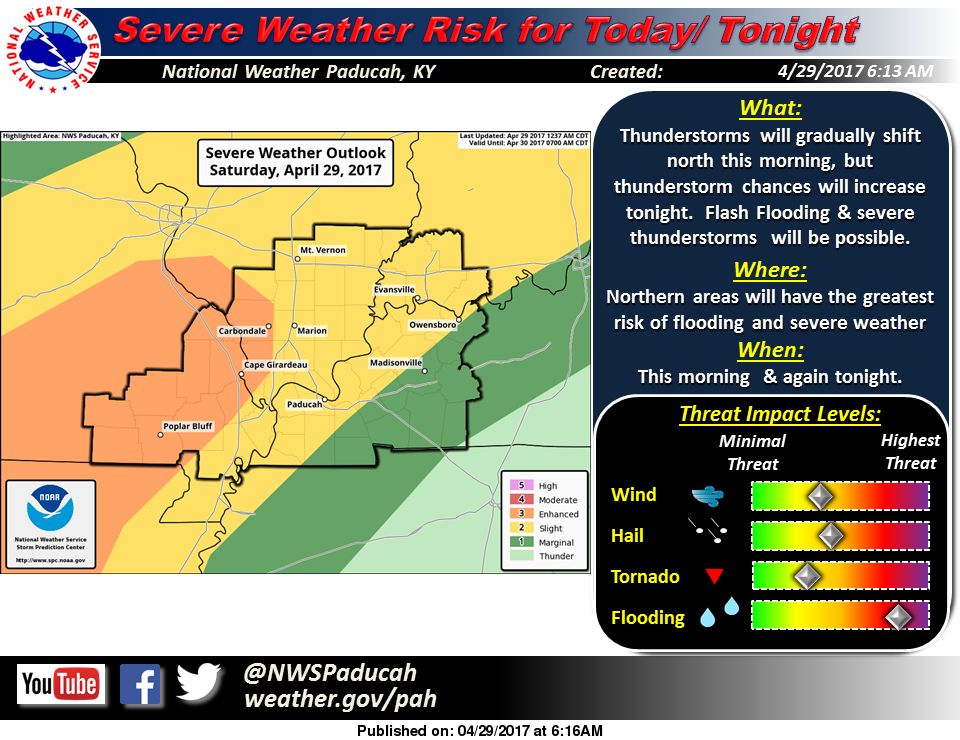
We could see a repeat of last night through the overnight hours tonight, with a risk of severe thunderstorms in the afternoon and evening.
We have a break in the action as the warm front that prompted the several inches of ran last night, is draped along I 70 according to where the precipitation is currently on radar. The Cardinal game has been rained out this afternoon.
If the cloud cover lifts, temperatures will like bounce up into the low to mid 80’s, and it will be very humid. This would provide fuel for pop up thunderstorms this afternoon and also juice the atmosphere and increase the severe thereat for tonight.
We are under a slight risk of severe weather from now until late Sunday night. On Sunday, there is the potential of a squall line forming in advance of an approaching cold front.
I will be away for a few hours this evening and I might not have internet access. Please follow your local media outlets for issuance weather statements.
Thank you all for the kind comments I have received over the last month and the ones that have encouraged me to share my take and opinion during severe weather events. I am not a meteorologist. I have only six credit hours of meteorology in college that I took as an elective. I have attended several seminars over the years, and I will continue training in this area.
The lake stage at Rend Lake is at 407.64.’ Which is nearly two feet over normal. The lake level to start to be concerned about is 410′. The lighter amount of rainfall helped flooding concerns overnight.
The Big Muddy River at Plumfield is at 16.66′. three feet over yesterday. It should hit flood stage at 20′ overnight. It is scheduled to crest at 27.8 feet sometime on Tuesday. Moderate flooding should take place. I would advise everyone to keep a close eye on this, especially if we get more heavy rain tonight.
Here are the statements issued by the National Weather Service in Paducah KY, pertaining to Franklin County.
Flood Warning National Weather Service Paducah CDT SAT APR 29 2017 /
Perry IL-Williamson IL-Saline IL-Jackson IL-Franklin IL-Hamilton IL- Bollinger MO-Perry MO-Cape Girardeau MO- 843 AM CDT SAT APR 29 2017 The National Weather Service in Paducah has issued a * Flood Warning for… Perry County in south central Illinois… Williamson County in southern Illinois… Saline County in southern Illinois… Jackson County in southern Illinois… Franklin County in south central Illinois… Hamilton County in south central Illinois… Northeastern Bollinger County in southeastern Missouri… Perry County in southeastern Missouri… Northern Cape Girardeau County in southeastern Missouri… * Until 230 PM CDT *
At 835 AM CDT, emergency management reported flooding in parts of the warned area. Numerous roads were flooded or closed, especially in the Marion area of southern Illinois. Some water rescues were conducted early this morning. Rainfall amounts of 4 to 6 inches have been common over the past 24 hours. * Rainfall has become lighter across the warned area, and this diminishing trend will continue through the morning. Additional rainfall amounts will be under an inch. Floodwaters will be slow to recede. * Some locations that will experience flooding include… Carbondale, Marion, Jackson, Herrin, Harrisburg, Perryville, West Frankfort, Murphysboro, Benton, Du Quoin, Pinckneyville, and McLeansboro.
PRECAUTIONARY/PREPAREDNESS ACTIONS… Turn around, don`t drown when encountering flooded roads. Most flood deaths occur in vehicles. Stay away or be swept away. River banks and culverts can become unstable and unsafe.
Flood Warning National Weather Service Paducah Kentucky 1028 AM CDT Sat Apr 29 2017
.Forecast Flooding Changed from Minor to Moderate Severity for the following rivers in Illinois… Big Muddy River near Plumfield and Murphysboro .
Heavy rainfall over the past few days will continue to cause rises at both Plumfield and Murphysboro Illinois. Plumfield is forecast to crest at 27.8 feet on Tuesday. Murphysboro is forecast to crest at 38.4 feet on Thursday morning.
PRECAUTIONARY/PREPAREDNESS ACTIONS… SAFETY MESSAGE… Never drive cars…trucks or sport utility vehicles through flooded areas. The water may be too deep to allow safe passage. Never allow children to play in or near flood waters. Stay tuned to NOAA Weather Radio or your local media for further statements and possible updated.
HAZZARDOUS WEATHER OUTLOOK
DAY ONE…Today and Tonight A Flash Flood Watch remains in effect for parts of Southern Illinois, Southeast Missouri, Southwest Indiana, and West Kentucky. It is strongly recommended that residents and travelers in the flash flood watch area stay away from flooded roadways and low lying areas. Flooding conditions are expected to worsen in these areas over the weekend. Refer to the Watch product for additional details.
Scattered severe thunderstorms will still be possible during the pre-dawn this Saturday, then again late Saturday night. Large hail and damaging wind gusts are expected to be the main severe weather hazards. Isolated tornadoes cannot be ruled out. .
DAYS TWO THROUGH SEVEN…Sunday through Friday A Flash Flood Watch will remain in effect until Sunday evening. Refer to the Watch product for additional details. Another round of strong to severe thunderstorms will be also possible Sunday afternoon and evening. Large hail and damaging wind gusts are again expected to be the main severe weather hazards. Isolated tornadoes cannot be ruled out.
There is a chance of thunderstorms again Wednesday. Any storms that develop are not expected to be severe at this time, but additional heavy rains could cause flooding issues, or impede recovery from any flooding that has already occurred over this weekend.
FLASH FLOOD WATCH
…FLASH FLOOD WATCH REMAINS IN EFFECT THROUGH LATE SUNDAY NIGHT… The Flash Flood Watch continues for * Portions of southern Illinois, southwest Indiana, western Kentucky, and southeast Missouri, including the following areas, in southern Illinois, Alexander, Edwards, Franklin, Gallatin, Hamilton, Hardin, Jackson, Jefferson, Johnson, Massac, Perry IL, Pope, Pulaski, Saline, Union, Wabash, Wayne IL, White, and Williamson. In southwest Indiana, Gibson, Pike, Posey, Spencer, Vanderburgh, and Warrick. In western Kentucky, Ballard, Carlisle, Daviess, Fulton, Henderson, Hickman, McCracken, and Union KY. In southeast Missouri, Bollinger, Butler, Cape Girardeau, Carter, Mississippi, New Madrid, Perry MO, Ripley, Scott, Stoddard, and Wayne MO. * Through late Sunday night *
The Flash Flood Watch remains in effect for all of southeast Missouri, Southern Illinois, Southwest Indiana, and a few border counties of West Kentucky along the Ohio and Mississippi Rivers. Numerous thunderstorms with very heavy rain are expected to persist across the Watch area through Saturday morning, gradually working back toward Southeast Missouri and Southwest Illinois during the afternoon and evening hours on Saturday.
Areas further east may see a break in the precipitation Saturday into Saturday night, but will then see more thunderstorms with very heavy rainfall move in from the west late Saturday night and through the day Sunday.
Radar estimates of two to five inches of rain have already fallen over parts of the watch area. An additional three to five inches of rain is expected to occur before the storm system exits the area Sunday night, with the heaviest rainfall expected in the Southeast Missouri Foothills. Locally higher amounts are also possible where numerous thunderstorms move across the same area.
In addition to the possibility of flash flooding of some roadways and streams, the heavy rainfall is expected to cause rises on many of the area rivers, particularly the smaller rivers in southeast Missouri, such as the Saint Francis, Black, and Current rivers.
Given the widespread rainfall across the region, other larger river systems, such as the Mississippi and Ohio Rivers will see rises in water levels occur in early May. Due to the prolonged period of rain, some of the flash flood warnings that are issued may be transitioned to overland flood warnings.
PRECAUTIONARY/PREPAREDNESS ACTIONS… A Flash Flood Watch means that conditions may develop that lead to flash flooding.
Flash flooding is a very dangerous situation. You should monitor later forecasts and be prepared to take action should Flash Flood Warnings be issued.


Speak Your Mind
You must be logged in to post a comment.