It’s coming -Freezing rain advisory until 6pm

A freezing rain advisory is still in effect for Franklin County until 6:00 pm today.

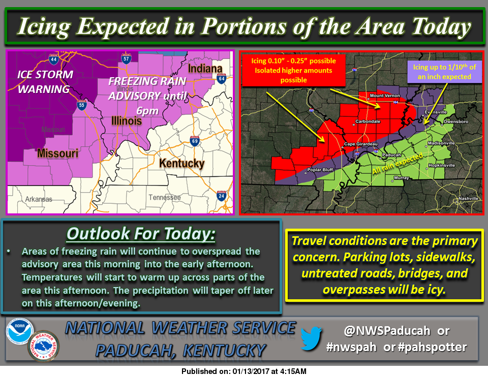
Here is a graphic for the amount of precipitation from the National Weather Service from Paducah KY:
friday the 13th weather chart #2

Here are the statements that are in effect for Franklin County from the National Weather Service in Paducah KY:

…FREEZING RAIN ADVISORY REMAINS IN EFFECT UNTIL 6 PM CST THIS EVENING… A FREEZING RAIN ADVISORY REMAINS IN EFFECT UNTIL 6 PM CST THIS EVENING. *

TIMING…THROUGH THE DAY TODAY.

* ICE ACCUMULATIONS…A GLAZE OF ONE TO TWO TENTHS OF AN INCH OF ICE LIKELY MOST AREAS. ACCUMULATIONS CLOSE TO ONE QUARTER OF AN INCH EXPECTED FROM MARBLE HILL TO JACKSON TO PERRYVILLE MISSOURI TO CARBONDALE AND PINCKNEYVILLE ILLINOIS.

* IMPACTS…TRAVEL IMPACTS EXPECTED…ESPECIALLY ON SECONDARY AND UNTREATED ROADS. SIDEWALKS AND PARKING LOTS MAY BE VERY SLICK IF NOT TREATED. VEHICLES WILL ICE OVER. SOME ICE ACCUMULATION ON POWER LINES IS EXPECTED.

PRECAUTIONARY/PREPAREDNESS ACTIONS… A FREEZING RAIN ADVISORY MEANS THAT LESS THAN ONE QUARTER INCH OF FREEZING RAIN OR FREEZING DRIZZLE WILL CAUSE HAZARDOUS TRAVEL CONDITIONS. BE PREPARED FOR SLIPPERY ROADS. SLOW DOWN AND USE CAUTION WHILE DRIVING.

THIS HAZARDOUS WEATHER OUTLOOK IS FOR PORTIONS OF SOUTHERN ILLINOIS, SOUTHWEST INDIANA, WESTERN KENTUCKY, AND SOUTHEAST MISSOURI.

.DAY ONE…TODAY AND TONIGHT A FREEZING RAIN ADVISORY IS IN EFFECT TODAY ALONG AND NORTHWEST OF A LINE FROM HENDERSON KENTUCKY TO POPLAR BLUFF MISSOURI…INCLUDING ALL OF SOUTHERN ILLINOIS UNTIL 600 PM.

ICE ACCUMULATIONS WILL BE HIGHEST FROM NORTH AND WEST OF A LINE FROM MARBLE HILL MISSOURI TO CARBONDALE ILLINOIS…WHERE UP TO ONE QUARTER INCH OF ICING IS POSSIBLE.  PLEASE REFER TO THE FREEZING RAIN ADVISORY FOR DETAILS. .

DAYS TWO THROUGH SEVEN…SATURDAY THROUGH THURSDAY SMALL CHANCES OF THUNDERSTORMS ARE POSSIBLE OVER ALL OR PART OF THE OUTLOOK AREA MONDAY THROUGH TUESDAY EVENING. NO WIDESPREAD SEVERE IS EXPECTED. LIGHTNING AND LOCALLY HEAVY DOWNPOURS WILL BE THE PRIMARY HAZARDS.

Here is a link to the seven day forecast for Franklin County

http://forecast.weather.gov/MapClick.php?map.x=176&map.y=89&site=pah&zmx=1&zmy=1#.WHjVkNQrJxA

We will keep everyone updated on road conditions and cancellations-

sd

 

Closings and cancellations 1/13/17

snow-dayI will use media sources to get every closing from I -64 south, since people go to this website all over Southern Illinois.  Please contact me with any closings by the following ways:

You can call or text me at 513-2516, call at 937-0253; PM me on Facebook (Steve Dunford), email me at sdunford1970@hotmail.com.

It will be nearly impossible to reply to individual requests if a school or business is closed.  I will update frequently with times.

Updated 6:30 am 1/13/17

I will lump all closings categorized by county.  Any type will be under the county listed.  

SCHOOLS-The only schools that I do not have in Southern Illinois are the following:  Century, The only Johnson County School I have is Lick Creek, Hardin County and Pope County.  

COLLEGES-  The only ones I have not heard anything about is Shawnee Community College and SIU, which never calls off.  The key staff needs to report at Morthland COllege.  

I am going to go to sporting events/business mode now.  

FRANKLIN COUNTY

Murphysboro at Benton Boys HS basketball/no make up date as of yet

Kids R My Business Day Care, Christopher

Girls Junior High Class L regional Benton/DuQuoin

JEFFERSON COUNTY

PERRY COUNTY 

UNION COUNTY

WASHINGTON COUNTY

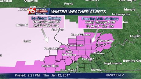
Freezing Rain Advisory for Franklin County.

The National Weather Service in Paducah KY has issued a freezing rain advisory for all of Southern Illinois, except Randolph and Washington counties, which is under an Ice Storm Warning.

Ice storm warning

I am going to share two statements.  One is from the NWS in Paducah.  Randolph and Washington counties are under the jurisdiction of the NWS in St. Louis.  Sometimes that is why they have different advisories and warnings.

Here are both statements from each NWS office.

Here is the one from the Paducah office.

…FREEZING RAIN ADVISORY IN EFFECT FROM 3 AM TO 6 PM CST FRIDAY… THE NATIONAL WEATHER SERVICE IN PADUCAH HAS ISSUED A FREEZING RAIN ADVISORY…WHICH IS IN EFFECT FROM 3 AM TO 6 PM CST FRIDAY. *

TIMING…LATE TONIGHT THROUGH THE DAY ON FRIDAY. * ICE ACCUMULATIONS…A GLAZE OF ONE TO TWO TENTHS OF AN INCH OF ICE LIKELY MOST AREAS. ACCUMULATIONS CLOSE TO ONE QUARTER OF AN INCH EXPECTED FROM MARBLE HILL TO PERRYVILLE…CARBONDALE AND PINCKNEYVILLE. *

IMPACTS…TRAVEL IMPACTS EXPECTED…ESPECIALLY ON SECONDARY AND UNTREATED ROADS. SIDEWALKS AND PARKING LOTS MAY BE VERY SLICK IF NOT TREATED. VEHICLES WILL ICE OVER. PRECAUTIONARY/PREPAREDNESS ACTIONS…

A FREEZING RAIN ADVISORY MEANS THAT LESS THAN ONE QUARTER INCH OF FREEZING RAIN OR FREEZING DRIZZLE WILL CAUSE HAZARDOUS TRAVEL CONDITIONS. BE PREPARED FOR SLIPPERY ROADS. SLOW DOWN AND USE CAUTION WHILE DRIVING.

Here is the one from NWS in St. Louis

…ICE STORM WARNING IN EFFECT FROM 9 AM FRIDAY TO NOON CST SUNDAY… THE NATIONAL WEATHER SERVICE IN SAINT LOUIS HAS ISSUED AN ICE STORM WARNING…WHICH IS IN EFFECT FROM 9 AM FRIDAY TO NOON CST SUNDAY. THE WINTER STORM WATCH IS NO LONGER IN EFFECT. * TIMING…

FREEZING RAIN WILL OVERSPREAD THE AREA FRIDAY MORNING FROM SOUTH TO NORTH. SIGNIFICANT ICING IS EXPECTED TO OCCUR FROM FRIDAY MORNING THROUGH SUNDAY MORNING. * ACCUMULATIONS…ONE QUARTER TO THREE QUARTERS OF AN INCH OF ICE. *

TEMPERATURES…UPPER 20S TO LOWER 30S. * WINDS…NORTHEAST 5 TO 10 MPH. * IMPACTS…THE ICE WILL RESULT IN HAZARDOUS TRAVEL CONDITIONS…ESPECIALLY ON BRIDGES…OVERPASSES…AND UNTREATED ROADS. PARKING LOTS AND SIDEWALKS WILL BECOME SLIPPERY AS WELL. DAMAGE TO TREES AND POWER LINES IS ALSO POSSIBLE.

PRECAUTIONARY/PREPAREDNESS ACTIONS… AN ICE STORM WARNING MEANS THAT A SEVERE AND DANGEROUS AMOUNT OF ICE ACCUMULATION IS OCCURRING OR EXPECTED TO ACCUMULATE… ESPECIALLY ON UNTREATED SURFACES…SUCH AS SIDEWALKS… DRIVEWAYS…ROADS… AND PARKING LOTS. THE HEAVY ICE ACCUMULATIONS WILL MAKE TRAVEL DANGEROUS OR IMPOSSIBLE.

IF YOU MUST TRAVEL…EXERCISE EXTREME CAUTION…AND BEGIN YOUR TRAVEL WITH A FULL TANK OF GAS…AND CARRY A WINTER STORM KIT WHICH INCLUDES A SHOVEL…FLASHLIGHT…CELLPHONE…FOOD AND WATER…AND BLANKETS OF EXTRA WARM CLOTHING. ICE ACCUMULATIONS AND WINDS WILL LIKELY LEAD TO SNAPPED POWER LINES AND FALLING TREE BRANCHES THAT ADD TO THE DANGER. &&

I listened to Dave Murray on a live Facebook  feed from Fox 2 in St Louis.  Summarizing his words, he had Pinckneyville to Salem in the bulls-eye.  I included St. Louis in this for one reason, if you have to go up there for a medical appointment, please consider cancelling.

We will have up to the minute cancellations.  Thank you for your response.  There has been over 3,000 views. – sd

Today is the day to prepare if not already

I have spent the last hour or so looking over models trying to get a consensus of the approaching weather system.  It seems like the consensus is the system will be dryer, but more widespread.

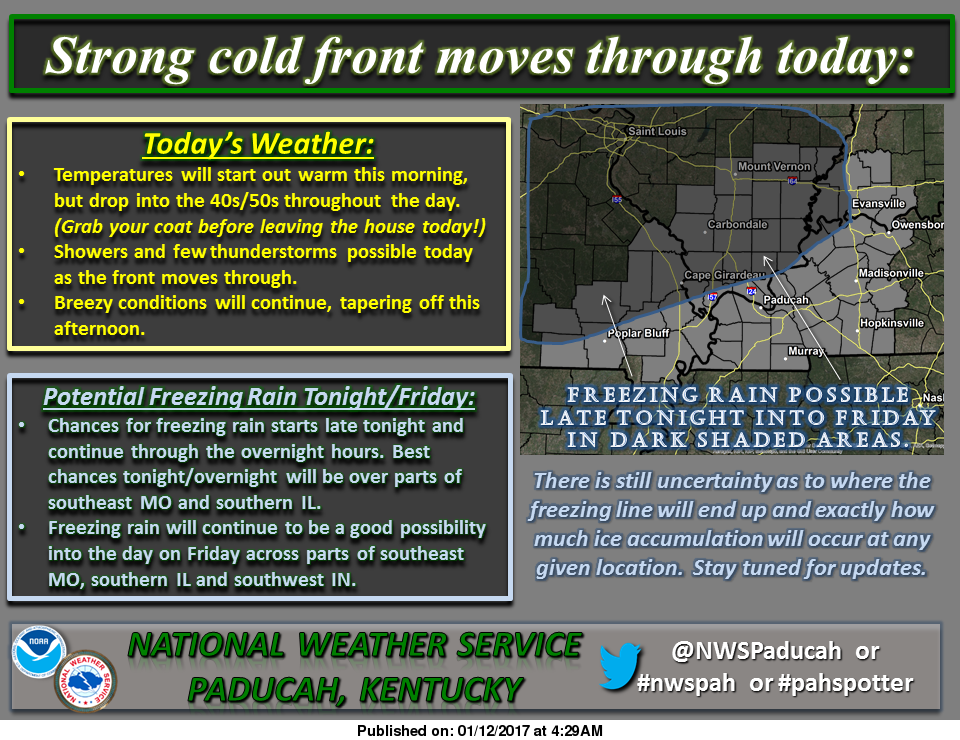
As of now the charts have been implying this, but it looks like the northwest part of Franklin County will get the greatest amount of impact with .1″ to .3″ inches of ice expected.  The southeastern part of the county is expected to receive less that .1″ of ice.  The places in between will receive .1″ to .2″ inches of ice.

January 12 graphic

The freezing line and amount of precipitation that we receive we exactly do not know until it gets on top of us.   There is a strong chance we are going to get ice tomorrow.  Today is the time to prepare.

This is something that we will not be in for several days as of yet, it ought to be something that we should prepare for a Friday at home and some brief power outages.

It is 69 degrees as we speak.  Temperatures will be falling till around 40 by nightfall.  The low is supposed to be 29 this evening.  The changeover from rain to freezing rain will take place between 10 pm to 12 pm.

Here is the products that have been issued by the National Weather Service for Franklin County-

SPECIAL WEATHER STATEMENT…GUSTY WINDS TO CONTINUE THIS MORNING…FREEZING RAIN LIKELY FRIDAY…

Freezing rain appears likely Friday across portions of southeast Missouri, southern Illinois and southwest Indiana. The activity could develop into the area before daybreak. It is expected to increase Friday morning, and last through the afternoon and then taper off. Confidence continues to increase the freezing air will make it as far south as a Greenville Missouri, Marion Illinois, Princeton Indiana line.

There may be some impacts to travel, especially on bridges, overpasses, and secondary roads. Sidewalks and parking lots may become quite slick as well. Elevated surfaces will ice. Expect a glaze on automobiles. Impacts to power should be minimal.

Meanwhile this morning, southwest winds will gust from 25 to 35 mph at times. This will cause loose objects to blow around. Travel may be difficult for some high profile vehicles. A cold front will move through this morning and early afternoon from north to south across the area. Winds will shift to the northwest and decrease behind the front.

THIS HAZARDOUS WEATHER OUTLOOK IS FOR PORTIONS OF SOUTHERN ILLINOIS, SOUTHWEST INDIANA, WESTERN KENTUCKY, AND SOUTHEAST MISSOURI

. .DAY ONE…TODAY AND TONIGHT A FEW ISOLATED THUNDERSTORMS WILL BE POSSIBLE TODAY. WINDS WILL GUST 25 TO 35 MPH THIS MORNING.

FREEZING RAIN WILL BE POSSIBLE LATE TONIGHT AND INTO THE OVERNIGHT HOURS ACROSS PORTIONS OF SOUTHEAST MISSOURI AND SOUTHERN ILLINOIS

. .DAYS TWO THROUGH SEVEN…FRIDAY THROUGH WEDNESDAY FREEZING RAIN WILL CONTINUE TO BE A THREAT AS WE HEAD THROUGH THE DAY ON FRIDAY ACROSS PORTIONS OF SOUTHEAST MISSOURI, SOUTHERN ILLINOIS AND PARTS OF SOUTHWEST INDIANA. FREEZING RAIN IS POSSIBLE GENERALLY NORTH AND WEST OF A LINE FROM POPLAR BLUFF MISSOURI TO EVANSVILLE INDIANA. THE HIGHEST ICE ACCUMULATIONS ARE EXPECTED NORTH AND WEST OF A LINE FROM GREENVILLE MISSOURI TO CARBONDALE AND MOUNT VERNON IL.

THUNDERSTORMS ARE POSSIBLE ON MONDAY AND MONDAY NIGHT…THEN AGAIN TUESDAY NIGHT THROUGH WEDNESDAY MORNING. NO WIDESPREAD SEVERE WEATHER IS EXPECTED. LIGHTNING AND LOCALLY HEAVY DOWNPOURS WILL BE THE PRIMARY HAZARDS. THIS PROLONGED PERIOD OF OFF AND ON RAINFALL MAY RESULT IN STANDING WATER IN LOW LYING AND POOR DRAINAGE AREAS…ALONG WITH POSSIBLE RISES IN SMALL CREEKS AND STREAMS.

Here is a link to the seven day forecast in Franklin County:

orecast.weather.gov/MapClick.php?map.x=176&map.y=89&site=pah&zmx=1&zmy=1#.WHeC8NQrJxA

We will keep the social media page updated with new charts and graphs issued.  If there is an advisory or a Winter Storm Watch issued for Franklin County will put this on the website as well as an updated closing and cancellation thread if it warrants.


Edwards explains reasons for ending career

Carl EdwardsNote: NASCAR driver Carl Edwards has quite the story of perseverance. His announcement to step out of the sport at the height of career rocked the racing world today. Here is an interview with him highlighting his racing career from his hometown Columbia Daily Tribune.

Monopoly Is Letting You Decide If They Should Change the Classic Tokens

monopoly-board-webIf you’ve ever wondered why there’s still a wheelbarrow token in the Monopoly board game, now’s your chance to ensure that the game pieces for the next version of the game are the ones that truly deserve to be there. From January 10 through January 31, Monopoly is asking the Internet to vote for the game pieces that they deem worthy to be the next eight tokens, ranging from current classic pieces like the thimble and top hat to more than 50 new options that include a rubber duck and a penguin. Some of the tokens that more accurately represent modern times are a wireless phone, a computer, a kissy face that bears a striking resemblance to an emoji, and a sports car. This isn’t the first time that Monopoly game pieces have been updated; in fact, the most recent update was the replacement of the iron token with Hazel the Cat in 2013. Please click to read the rest of the story from Time magazine.

Obama calls on supporters to renew fight for liberal values in farewell address

USA Today photo

USA Today photo

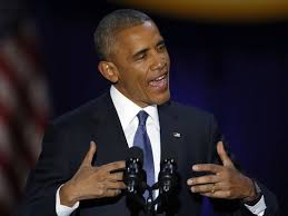
In his farewell address to the nation Tuesday night, a tearful President Obama called on Americans to keep working toward income equality, racial healing and bipartisan cooperation — the same goals he was unable to achieve over the past eight years. With 10 days remaining in his presidency, Mr. Obama traveled to Chicago to deliver his valedictory speech to about 20,000 supporters and urge them to renew the fight for liberal values in the administration of Republican Donald Trump. “We must forge a new social compact,” Mr. Obama said. “If we don’t create opportunity for all people, the disaffection and division that has stalled our progress will only sharpen in years to come.” The president warned of threats facing democracy, saying race “remains a potent and often divisive force in our society.” Please click on the link to read the article from Dave Boyer of the Washington Times

Trump gives a press conference for the ages

(AP photo)

(AP photo)

President-Elect Donald Trump gave his first news conference since winning the election — and it was epic. If pundits and the Washington elite think Mr. Trump is going to change his tone or style going into the White House, they’re sorely mistaken. He’s a fighter. He’s accomplished too much in his life, overcome too many obstacles to bow down to anybody. Including the press. “No, I’m not going to give you an answer,” Mr. Trump told CNN’s Jim Acosta. “You are fake news.” The exchange came on the heels of an explosive CNN report that said the intelligence community presented a briefing to both President Obama and Mr. Trump “including allegations that Russian operatives claim to have compromising personal and financial information about Mr. Trump.” Except no one knows if that’s true — or has verified the contents of the report on which it was based. Please read the rest of the story from Kelly Ridell of the Washington Times…(This is an op-ed piece but it also gives the highlights of today)

Madigan re-elected Speaker; Senate adopts leader term limits

Speaker of the House Michael Madigan  (Chicago Tribune photo)

Speaker of the House Michael Madigan (Chicago Tribune photo)

Michael Madigan was re-elected Wednesday to a 17th term leading the Illinois House, putting him on track to soon become the nation’s longest-serving statehouse speaker in more than a century, but he faces an ongoing budget crisis and a shrinking Democratic majority. A member of the Illinois House since 1971, Madigan has held the top job for a total of 32 years. According to the Illinois Campaign for Political Reform, Democrat Solomon Blatt of South Carolina served 33 years – from 1937 to 1946 and again from 1951 to 1973. Madigan, who was elected speaker in 1983 but lost his majority from 1995 to 1997 before retaking it, would eclipse Blatt’s tenure early next year. The Illinois Senate took its own historic step Wednesday borne of the budget stalemate. The Democratic-controlled body voted for the first time to impose 10-year term limits on its leaders as both chambers got down to business in the General Assembly’s 100th session. Please Click to read the rest of the story from John O’ Connor of the Associated Press ran by the Springfield Journal-Register

Brenda Robbins – Sesser

Brenda RobbinsBrenda K. Robbins, 73, of Sesser IL, passed away on Tuesday January 10. 2017 at 3:13 PM at the Franklin Hospital Emergency Room in Benton.

She was born to Alvin Lee and Rosalie (Minor) McBride. After the loss of her father at a young age her mother Rosalie then married Carl Galant. Brenda was married to Don Robbins on June 16, 1962 and he survives of Sesser.

She was a bank teller for many years at the Benton Community Bank, now known as the US Bank in Benton ,and was a member of the First Baptist Church in Sesser.

She is survived by her husband, one daughter Debbie (Chuck) Eubanks of New Iberia, LA, and a son Donnie (Penny) Robbins of Sesser, five grandchildren; Anthony (Jen) Eubanks, Nicole (JD) Downey, Peyton Robbins, Presley Robbins, and Parker Robbins. four great grandchildren; Jaylon, Jarrick, Elijah, and Timothy and one brother Dale (Pat) Galant of Bradley, IL.

She was preceded in death by her father, mother and step-father.

Funeral services will be on Friday January 13, 2017 at 11:00 A.M. at the Brayfield-Gilbert Funeral Home in Sesser, with Brother Tom DeWitt officiating.  Burial will be in Horse Prairie Cemetery in Sesser.  Visitation will be on Thursday January 12, 2016 from 5:00 P.M. until 8:00 P.M. at the funeral home.

In lieu of flowers, donations can be made to the First Baptist Church Benevolence Fund, and will be accepted at the funeral home.

For more information go to our website www.gilbertfuneralhomes.com

Benton, West Frankfort, Illinois News | Franklin County News