 The NWS Storm Prediction Center has issued a * Severe Thunderstorm Watch for portions of Southern Illinois Southwest Indiana Western and south-central Kentucky Far southeast Missouri Western and middle Tennessee * Effective this Saturday afternoon from 515 PM until Midnight CDT. .
..THIS IS A PARTICULARLY DANGEROUS SITUATION… * Primary threats include… Widespread damaging winds expected with scattered significant gusts to 80 mph likely Scattered large hail and isolated very large hail events to 2 inches in diameter possible A few tornadoes possible
SUMMARY…A very fast-moving line of convection will continue to pose a risk for widespread wind damage as it races east-southeastward through the evening hours. A few tornadoes and hail will also be possible with the fast-moving squall line and/or other line-preceding storms. The severe thunderstorm watch area is approximately along and 70 statute miles north and south of a line from 30 miles west northwest of Cape Girardeau MO to 55 miles east southeast of Bowling Green KY. For a complete depiction of the watch see the associated watch outline update
PRECAUTIONARY/PREPAREDNESS ACTIONS… REMEMBER…A Severe Thunderstorm Watch means conditions are favorable for severe thunderstorms in and close to the watch area. Persons in these areas should be on the lookout for threatening weather conditions and listen for later statements and possible warnings. Severe thunderstorms can and occasionally do produce tornadoes.

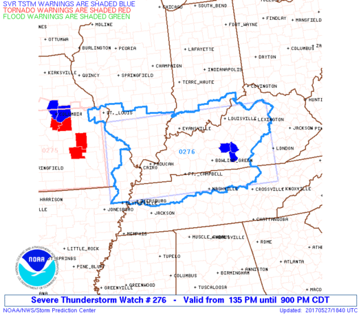 The NWS Storm Prediction Center has issued a * Severe Thunderstorm Watch for portions of Southern Illinois Southern Indiana Western and Central Kentucky Southeast Missouri Northern Tennessee * Effective this Saturday afternoon and evening from 135 PM until 900 PM CDT.
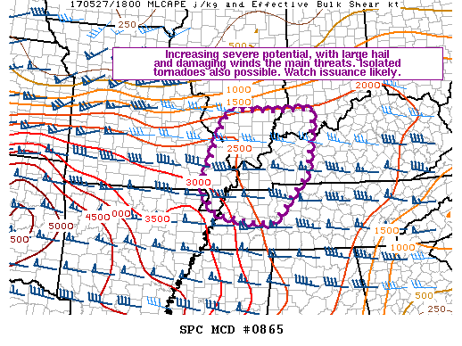

 Springfield…. Today Representative David Severin (R-Benton) unanimously passed Senate Bill 730 through the Illinois House of Representatives, which extends the Petroleum Education and Marketing Act (PEMA). The Act was planned to expire on January 1, 2018 but will now be extended another 10 years to January 1, 2028.