Wind chill factor below zero through tomorrow…..temps in the 50’s by the weekend

Special weather statement

…Cold temperatures and wind chills will continue to make it
very uncomfortable tonight…

Low temperatures tonight will drop into the 0 to 5 above zero
range. Combined with northwest winds at 3 to 6 mph, wind chill
readings will drop into the 0 to near 10 degrees below zero range
tonight through mid morning. These conditions will not only be
very uncomfortable, but it will make it very difficult for road
crews to continue to treat and clear area roadways. People need to
be very cautious when traveling, and wear plenty of warm clothing
when venturing outside.

Hazardous Weather Outlook

DAY ONE…This Afternoon and Tonight Wind chill readings will be in the 5 above to near 10 below zero range today into tonight.

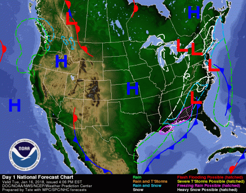
.DAYS TWO THROUGH SEVEN…Wednesday through Monday There is a slight chance of thunderstorms Sunday afternoon and evening, mainly in southeast Missouri. The probability for widespread hazardous weather is low.

Seven Day Forecast

This Afternoon
Mostly cloudy, with a high near 11. Wind chill values as low as -3. Northwest wind around 9 mph.
Tonight
Mostly cloudy, with a low around 3. Wind chill values as low as -6. West northwest wind 3 to 7 mph.
Wednesday
Sunny, with a high near 23. Wind chill values as low as -6. Light and variable wind becoming west northwest around 6 mph in the morning.
Wednesday Night
Clear, with a low around 13. South southwest wind 3 to 6 mph.
Thursday
Sunny, with a high near 37. South southwest wind 6 to 11 mph.
Thursday Night
Clear, with a low around 23. South southwest wind 7 to 10 mph.
Friday
Sunny, with a high near 43. South southwest wind 7 to 13 mph, with gusts as high as 18 mph.
Friday Night
Partly cloudy, with a low around 35. South southwest wind around 11 mph.
Saturday
Partly sunny, with a high near 50. South southwest wind 9 to 11 mph.
Saturday Night
A slight chance of showers. Mostly cloudy, with a low around 45. South wind around 10 mph.
Sunday
A chance of showers. Mostly cloudy, with a high near 57. South wind 10 to 14 mph, with gusts as high as 24 mph.
Sunday Night
Showers likely and possibly a thunderstorm. Mostly cloudy, with a low around 40. South wind around 14 mph, with gusts as high as 24 mph.
Monday
A chance of sprinkles. Partly sunny, with a high near 48. West wind 10 to 14 mph, with gusts as high as 25 mph.


Franklin County Farm Bureau News

By Gay Bowlin, Franklin County Farm Bureau Manager  

Hello 2018 – sorry for not having an article before now but I attended the American Farm Bureau Federation Annual Convention in Nashville, TN from January 5th through January 9th. I was able to see President Trump while I was there. Whether you are a fan or not it is still a thrill to get to see a seated President in person. Everyone in attendance (over 5,000 from across the U.S.) witnessed Him signing two Executive Orders for Rural Broadband Internet Service. I know in our area this is a huge issue as we are such a rural area.

At the AFBF “Our delegates successfully introduced several submittals on farm policy, Conservation Reserve Program (CRP), seed protection, property rights, environment and conservation issues,” said Richard Guebert, Jr., Illinois Farm Bureau president. “We expect Congress to debate and pass a farm bill in 2018. The policies adopted will better position us for those deliberations.”

Additional Illinois polices adopted by national farmer-delegates included:

– Allowing farmers to sign up once for the duration of a federal farm bill assuming no changes in a farming operation

– Requiring seed for government program acres to be free of invasive species of weed seed, such as Palmer amaranth

– A new section on solar energy designed to protect the property rights of farmers and other landowners

A new Illinois law that took effect Jan. 1 makes the bumper-to-bumper truck length on county, road district or municipal roads uniform with the length allowed on the state highway system, according to Kirby Wagner, Illinois Farm Bureau assistant director of transportation.

Under the new law, the overall limit from bumper to bumper increased to 65 feet from the previous 55 feet. On Class I and Class II routes, which include interstates and other major designated state and federal highways, the truck-trailer overall length is unlimited; however, a semitrailer length is still restricted to a maximum 53 feet.

This length uniformity will allow Illinois farmers to more efficiently haul from farm to market, especially on longer trips, Wagner noted.

Under the new law, units of local government are not required to widen or otherwise alter nonstate highways to accommodate the new truck and trailer lengths, Wagner said. That unit of government may also seek recovery for the cost to repair damaged highways that result from the operations of trucks under the new allowed length.

In addition, the law now sets the allowable kingpin-to-last-axle length to a maximum of 42 feet and 6 inches on local roads – the same restriction on most state highways, Wagner continued. He pointed out Class I and Class II routes have a kingpin-to-last-axle length restriction of 45 feet and 6 inches.

A separate law also makes frequency of safety inspections more uniform for truck-tractor semitrailer combinations operated in intrastate and interstate commerce. Semis operated within Illinois are now required to undergo a safety inspection only once every 12 months instead of every six months.

Trucks – other than semis – registered for more than 8,000 pounds and operated wholly within Illinois must still undergo twice-a-year inspections at licensed truck safety test lanes, Wagner said.

The new year brought final rules for the Unified Carrier Registration (UCR). Today, the federal Motor Carrier Safety Administration published rules for the 2018 fees, which will decrease an estimated 9.1 percent compared to 2017. States are recommended not to start enforcing 2018 compliance until 90 days after rule publication.

Any farm vehicle owner required to have and display a U.S. Department of Transportation number must also register and pay a UCR fee.

Remember we are farmers working together. If we can help let us know

BIT/Midwinter Classic Is On For Tonight

I received word the Benton Invitational  Tournament is on for tonight.  I originally received word it was off and I do apologize for any inconvenience that I might have caused.

The slate of Games that will be scheduled for last night at the BIT will be played tonight.

The Tuesday night games will be played as scheduled at West Frankfort.  There has been a Saturday morning session scheduled. -Steve


Edward John Staszak-Herrin

Edward John Staszak, 62 of Herrin passed away on Sunday January 14, 2018 at 8:30 AM at his home.

He was born on September 19, 1955 in Chicago to Edward and Elizabeth (Kiebles) Staszak.  He married Cassilda (Johnson) Staszak on October 26, 1996 and she survives of Herrin.

He is also survived by his son Keith Staszak of Christopher; step-son Leon Charley Walker of West Virginia; one grandson Xander Leon Walker; brothers and sisters Kenneth Staszak of Buckner, Donna Jackson of Sesser, Julie Martin of Christopher, Daniel Staszak of Johnston City and Carrie Staszak of Cape Girardeau, MO.

He was preceded in death by his parents and one sister Felicia Dick.

He was a truck driver and service technician for the Coca-Cola Bottling Company in DuQuoin.

Funeral services will be on Friday January 19, 2018 at 1:00 PM at the Gilbert Funeral Home in Christopher with Father Urban Osuji officiating.  Visitation will be on Friday from 11:00 AM until 1:00 PM at the funeral home.  Burial will be at St Andrews Catholic Cemetery in Christopher.

For a full obituary go to our website www.gilbertfuneralhomes.com

With plans for Sonic and solar power, mayor says 2018 looks to be ‘very bright’ for Benton

Benton Mayor Fred Knodritz (File photo)

BENTON — Benton Mayor Fred Kondritz hopes the recent announcement that Sonic is coming to town will be a trend for 2018.

The national fast food chain on Jan. 2 purchased the old city hall on West Main Street for $176,000 at auction. Kondritz said that development is just one of several he is hoping to tackle in the coming 12 months.

Kondritz said he has a list of six properties on Main Street that he is hoping to see movement on in the next few months.

Please click read the rest of the article from Isaac Smith of the Southern Illinoisan.

http://thesouthern.com/news/local/communities/benton/with-plans-for-sonic-and-solar-power-mayor-says-looks/article_253fa022-44c9-5661-90a8-0e8b2e981728.html

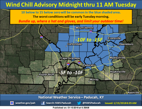
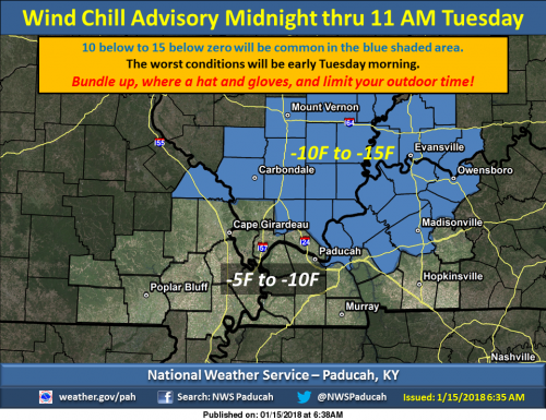
Wind chill advisory goes into effect at midnight until 11:00 a.m. tomorrow


Wind chills expected to be around -15 tonight into tomorrow


Northwest winds will spread Arctic air back across the region tonight. Temperatures will fall to near zero by daybreak Tuesday, and the wind will make it feel like 10 below to 15 below zero in the shaded area. Elsewhere, conditions will only be slightly better with 5 below to 10 below zero wind chills expected. Conditions will be slow to improve Tuesday morning, and wind chills may not climb above zero at all in the Advisory area Tuesday. (NWS Paducah)

Wind chill advisory

…WIND CHILL ADVISORY REMAINS IN EFFECT FROM MIDNIGHT TONIGHT TO
11 AM CST TUESDAY…

* WHAT…Very cold wind chills expected. The cold wind chills
will cause frostbite in as little as 30 minutes to exposed
skin. Expect wind chills to range from 5 below zero to 15
below zero.

* WHERE…Portions of southern Illinois and southeast Missouri.

* WHEN…Midnight to 11 AM Tuesday.

* ADDITIONAL DETAILS…The cold wind chills will cause frostbite
in as little as 30 minutes to exposed skin.

PRECAUTIONARY/PREPAREDNESS ACTIONS…

A Wind Chill Advisory means that cold air and the wind will
combine to create low wind chills. Frost bite and hypothermia can
occur if precautions are not taken. Make sure you wear a hat and
gloves.

Seven Day Forecast

Tonight
A 20 percent chance of snow before 8pm. Mostly cloudy, with a low around 2. Wind chill values as low as -12. Northwest wind 8 to 11 mph, with gusts as high as 18 mph.
Tuesday
A chance of flurries between 2pm and 5pm. Mostly cloudy, with a high near 14. Wind chill values as low as -14. West northwest wind 9 to 11 mph, with gusts as high as 20 mph.
Tuesday Night
Mostly cloudy, with a low around 7. Wind chill values as low as -3. Northwest wind around 6 mph.
Wednesday
Sunny, with a high near 23. Wind chill values as low as -3. Northwest wind 5 to 7 mph becoming southwest in the afternoon.
Wednesday Night
Mostly clear, with a low around 12. South southwest wind 3 to 7 mph.
Thursday
Sunny, with a high near 36. South southwest wind 6 to 13 mph, with gusts as high as 22 mph.
Thursday Night
Mostly clear, with a low around 22. South southwest wind 8 to 11 mph.
Friday
Sunny, with a high near 43. South southwest wind 8 to 10 mph.
Friday Night
Partly cloudy, with a low around 37. South southwest wind around 11 mph.
Saturday
Mostly cloudy, with a high near 52. South wind around 11 mph.
Saturday Night
A chance of showers. Mostly cloudy, with a low around 46. South wind around 11 mph.
Sunday
A chance of showers. Mostly cloudy, with a high near 55. South wind 11 to 13 mph, with gusts as high as 26 mph.
Sunday Night
A chance of showers. Mostly cloudy, with a low around 36. South wind 11 to 13 mph becoming west southwest after midnight. Winds could gust as high as 25 mph.
Monday
Mostly sunny, with a high near 43. West wind 9 to 13 mph, with gusts as high as 22 mph.


Update on the latest road conditions at 6:00

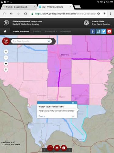
This is from the website https://www.gettingaroundillinois.com/.   

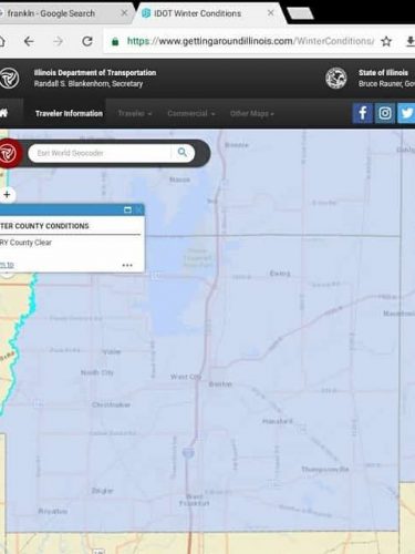
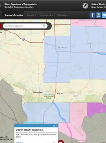
As you can see in the images below the situation has improved.  State highways in Franklin County have scattered slick spots.

Along the route 13 corridor things are all clear.

Secondary roads and parking lots hare still hazardous.  Black ice might be a problem, as temperatures are expected to be in the single digits.

Below is a map of Franklin County and a map of Southern Illinois for state highways.

The legend is the following

Magenta:  Roads are completely snow packed.

Pink:  Roads are mainly snow packed.

Blue:  There will be scattered slick spots.

Tan:  Roads are clear. -sd


Molina confirms plans to retire when contract expires

ST. LOUIS, MO  The Cardinal backstop signed an extension that keeps him in St. Louis through 2020, and plans to call call it a career after that.

The last two Cardinal backstops, Cardinal Manager Mike Matheny and Yadier Molina

“Three more years. That’s it,” he said Monday. “It could change, but right now just three years.”

The veteran backstop says he plans to enjoy his family once his contract is up, and seemed very at peace with the decision to set an endpoint on his historic career.

Please click on the link below from J.J. Bailey of KMOV-TV.

http://www.kmov.com/story/37269250/molina-confirms-plans-to-retire-when-contract-expires

NOTE:  This is one of the best Cardinal articles I have read in the offseason.


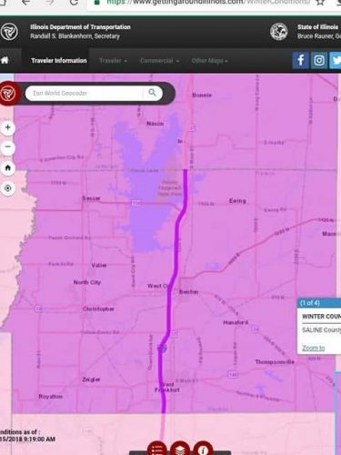
State Highways in Franklin County completely covered in ice and snow.

Below are a couple screen shots of road conditions from the website https://www.gettingaroundillinois.com/

This website is a handy tool during winter weather events.

The legend to the maps are the following:

Magenta:  State highways fully covered

Pink:  State highways mainly covered

Blue:  State highways partially covered

Below you will see the road conditions for Franklin County, the next will be all of Southern Illinois.  I will update every two hours.

Road conditions as of 9:15 a.m.


Conditions as of 9:15


Winter weather advisory in effect until 6 p.m Wind Chill Advisory goes into effect tonight at midnight

Northwest winds will spread Arctic air back across the region tonight. Temperatures will fall to near zero by daybreak Tuesday, and the wind will make it feel like 10 below to 15 below zero in the shaded area. Elsewhere, conditions will only be slightly better with 5 below to 10 below zero wind chills expected. Conditions will be slow to improve Tuesday morning, and wind chills may not climb above zero at all in the Advisory area Tuesday. (NWS Paducah)

Winter Weather Statement from the National Weather Service

…WINTER WEATHER ADVISORY REMAINS IN EFFECT UNTIL 6 PM CST THIS
EVENING…
…WIND CHILL ADVISORY IN EFFECT FROM MIDNIGHT TONIGHT TO 11 AM
CST TUESDAY…

* WHAT…Snow expected. Very cold wind chills expected. Plan on
slippery road conditions, including during the morning
commute. Total snow accumulations of 1 to 3 inches are
expected. Expect wind chills to range from 5 below zero to 15
below zero.

* WHERE…All of Southwest Indiana, much of southern Illinois,
and Perry County in southeast Missouri.

* WHEN…For the Winter Weather Advisory, through 6 PM today. For
the Wind Chill Advisory, midnight to 11 AM Tuesday.

* ADDITIONAL DETAILS…Be prepared for reduced visibilities at
times. The cold wind chills will cause frostbite in as little
as 30 minutes to exposed skin.

PRECAUTIONARY/PREPAREDNESS ACTIONS…

A Winter Weather Advisory for snow means periods of snow will
cause primarily travel difficulties. Be prepared for snow covered
roads and limited visibilities, and use caution while driving.
The latest road conditions for the state you are calling from can
be obtained by calling 5 1 1.

A Wind Chill Advisory means that cold air and the wind will
combine to create low wind chills. Frost bite and hypothermia can
occur if precautions are not taken. Make sure you wear a hat and
gloves.

Hazardous Weather Outlook

.DAY ONE…Today and Tonight

A Winter Weather Advisory is in effect for the entire area today.
It will continue through Midnight over west Kentucky and far
southeast Missouri. Snow accumulations up to 3 inches are
expected.

A Wind Chill Advisory is in effect for areas along and north of
line from Perryville Missouri to Princeton and Calhoun Kentucky
after midnight tonight. Wind chills from 10 below to 15 below
zero are expected. Farther south across the region, wind chills
will range from 5 below to 10 below zero.

.DAYS TWO THROUGH SEVEN…Tuesday through Sunday

A Wind Chill Advisory will continue until 11 AM Tuesday for areas
along and north of line from Perryville Missouri to Princeton and
Calhoun Kentucky . Wind Chills from 10 below to 15 below zero are
expected. Farther south across the region, wind chills will range
from 5 below to 10 below zero.

Wind chills will drop into the zero to 10 below zero range across
the region Tuesday night into early Wednesday morning.

Seven Day Forecast 

M.L.King Day
Snow, mainly before 11am. Temperature falling to around 20 by 5pm. West southwest wind 10 to 13 mph becoming northwest in the afternoon. Winds could gust as high as 22 mph. Chance of precipitation is 80%. Total daytime snow accumulation of 1 to 2 inches possible.
Tonight
Mostly cloudy, with a low around 2. Wind chill values as low as -12. Northwest wind 9 to 11 mph, with gusts as high as 18 mph.
Tuesday
A chance of flurries after 11am. Mostly cloudy, with a high near 14. Wind chill values as low as -14. West northwest wind 9 to 11 mph, with gusts as high as 20 mph.
Tuesday Night
Mostly cloudy, with a low around 6. Wind chill values as low as -4. Northwest wind 6 to 8 mph.
Wednesday
Sunny, with a high near 23. Northwest wind 5 to 7 mph becoming southwest in the afternoon.
Wednesday Night
Mostly clear, with a low around 11. South southwest wind 3 to 7 mph.
Thursday
Sunny, with a high near 35. South southwest wind 7 to 14 mph, with gusts as high as 20 mph.
Thursday Night
Mostly clear, with a low around 22. South southwest wind 8 to 13 mph.
Friday
Mostly sunny, with a high near 41. South southwest wind 8 to 10 mph.
Friday Night
Mostly cloudy, with a low around 36. South southwest wind around 10 mph.
Saturday
A slight chance of light rain. Mostly cloudy, with a high near 52. South wind 10 to 13 mph, with gusts as high as 20 mph.
Saturday Night
A chance of light rain. Mostly cloudy, with a low around 46. South wind 10 to 13 mph, with gusts as high as 20 mph.
Sunday
Showers likely. Mostly cloudy, with a high near 54. South wind 13 to 16 mph, with gusts as high as 28 mph.
Benton, West Frankfort, Illinois News | Franklin County News