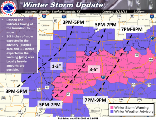
Here is the current Winter Storm Warning/Winter Weather Advisory for this afternoon and tonight. Expect 1-3 inches of snow in the advisory areas and 3-5 inches over the warning areas, with locally heavier amounts possible. Use extreme caution if driving as roads may become slick and visibility will be poor in heavier snow bands. (NWS Paducah)
WINTER WEATHER ADVISORY UNTIL 4 AM
.A burst of heavy wet snow expected late today and tonight...

.A low pressure system will form over the Tennessee Valley this
evening. Colder north winds will cause rain to change to snow. A
burst of heavy snow could produce a quick 1 to 3 inches, with
isolated higher totals possible.
.WINTER WEATHER ADVISORY IN EFFECT UNTIL 4 AM CDT MONDAY… * WHAT…Snow expected. Total snow accumulations of 1 to 3 inches are expected. Isolated higher amounts are possible in small bands of heavy snow. * WHERE...Portions of southwest Indiana, southeast Missouri and southern Illinois. * WHEN…Until 4 AM CDT Monday. * ADDITIONAL DETAILS…Plan on slippery road conditions. A burst of heavy snow could produce poor visibility below one-half mile. Although pavement temperatures will be above freezing, snowfall rates up to an inch per hour could produce a slushy accumulation on the roads, especially untreated, elevated roadways. PRECAUTIONARY/PREPAREDNESS ACTIONS... A Winter Weather Advisory for snow means periods of snow will cause primarily travel difficulties. Be prepared for snow covered roads and limited visibilities, and use caution while driving. The latest road conditions.
FRANKLIN COUNTY BREAKDOWN
In my opinion, the NWS included all the counties in the Paducah warning area in case there is a snow burst. Here is the forecast exclusive to every town in Franklin County updated by the National Weather Service.
- North of Route 14, the NWS has not issued an accumulation amount
- Zeigler, Royalton, and West Frankfort around an inch
- Thompsonville 1″ – 2″
- Keep in mind, there will be heavy snow bands, that could increase this amount
- Please be my eyes this afternoon and send accumulation amounts that way I can pass them along to the NWS.
WINTER STORM WARNING FOR GALLATIN, POPE HARDIN AND MASSAC COUNTIES
...A burst of heavy wet snow expected late today and tonight...

.A low pressure system will form over the Tennessee Valley this
evening. Colder north winds will cause rain to change to snow. A
burst of heavy snow could produce a quick 1 to 3 inches, with
isolated higher totals possible.
..WINTER STORM WARNING IN EFFECT UNTIL 4 AM CDT MONDAY...

* WHAT...Heavy wet snow expected. Total snow accumulations of 3 to
  5 inches are expected. Isolated higher amounts are possible in
  small bands of heavy snow.

* WHERE...Portions of western Kentucky and southern Illinois.

* WHEN...Until 4 AM CDT Monday.

* ADDITIONAL DETAILS...Plan on difficult travel conditions. Be
  prepared for significant reductions in visibility at times. Snow
  accumulations are expected, especially on grass, trees and
  untreated,elevated roadways. However, more hazardous travel
  conditions mat occur if the snow rates increase with
  temperatures near freezing.


PRECAUTIONARY/PREPAREDNESS ACTIONS...

A Winter Storm Warning for snow means severe winter weather
conditions will make travel very hazardous or impossible. If you
must travel, keep an extra flashlight, food and water in your
vehicle in case of an emergency. The latest road conditions for
the state you are calling from can be obtained by calling 5 1 1.


Speak Your Mind
You must be logged in to post a comment.