Wind advisory until 5:00 p.m. for Southern Illinois

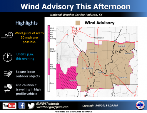
A Wind Advisory is in effect for most of the Heartland. Southwest to West Winds will increase to average speeds in the 15 to 30 mph range during the afternoon. Gusts may be as high as 40 to 50 mph at times. (NWS Paducah)

…WIND ADVISORY IN EFFECT FROM NOON TODAY TO 5 PM CST THIS AFTERNOON... The National Weather Service in Paducah has issued a Wind Advisory, which is in effect from noon today to 5 PM CST this afternoon.

* TIMING…This afternoon. * WINDS…Southwest winds 20 to 30 mph with gusts 40 to 50 mph.

* IMPACTS…Loose outdoor objects not secured may be blown around. Some tree limbs could come down. Driving high profile vehicles will be more difficult.

PRECAUTIONARY/PREPAREDNESS ACTIONS… A wind advisory is issued when sustained winds are expected to reach 30 mph or greater for longer than one hour…or wind gusts are expected to reach 40 mph for any duration.

This Hazardous Weather Outlook is for portions of southern Illinois, southwest Indiana, western Kentucky, and southeast Missouri. .

DAY ONE…Today and Tonight A Red Flag Warning is in effect this afternoon for the southeast Missouri Ozarks. Refer to the Warning for details. A Wind Advisory is in effect this afternoon for most of the area. Refer to the Advisory for details. Flood warnings will continue. Reference the warnings and statements for details. .

DAYS TWO THROUGH SEVEN…Wednesday through Monday Flood warnings will continue. Reference the warnings and statements for details. A small chance of thunderstorms is possible Saturday night, for southern sections of western Kentucky and southeast Missouri. Severe storms are not expected.

.SPOTTER INFORMATION STATEMENT… Spotter activation will not be needed.

SEVEN DAY FORECAST 

This Afternoon
Sunny early, then becoming mostly cloudy, with a temperature falling to around 47 by 5pm. Breezy, with a west wind 15 to 20 mph, with gusts as high as 38 mph.
Tonight
Scattered rain showers before 10pm, then scattered rain and snow showers between 10pm and midnight, then scattered snow showers after midnight. Mostly cloudy, with a low around 33. West wind 11 to 15 mph, with gusts as high as 31 mph. Chance of precipitation is 30%.
Wednesday
Cloudy, then gradually becoming mostly sunny, with a high near 40. West northwest wind 11 to 14 mph, with gusts as high as 26 mph.
Wednesday Night
Partly cloudy, with a low around 27. West northwest wind 6 to 10 mph.
Thursday
Sunny, with a high near 41. West northwest wind 7 to 11 mph.
Thursday Night
Partly cloudy, with a low around 28. West northwest wind around 6 mph becoming light and variable in the evening.
Friday
A slight chance of snow before 9am, then a chance of rain. Mostly cloudy, with a high near 51. South wind 3 to 8 mph. Chance of precipitation is 30%.
Friday Night
Rain likely, mainly before midnight. Mostly cloudy, with a low around 40. South southeast wind around 7 mph becoming northwest after midnight.
Saturday
A slight chance of rain after noon. Mostly cloudy, with a high near 55. North wind around 7 mph.
Saturday Night
A chance of rain. Mostly cloudy, with a low around 38. North wind 7 to 9 mph.
Sunday
A chance of rain. Partly sunny, with a high near 47. North northwest wind 10 to 15 mph, with gusts as high as 24 mph.
Sunday Night
Partly cloudy, with a low around 31. North northwest wind 8 to 11 mph.
Monday
Sunny, with a high near 49. North northwest wind 8 to 10 mph.


Print Friendly, PDF & Email

Speak Your Mind

Benton, West Frankfort, Illinois News | Franklin County News