Sunny and beautiful today….rain moving in after midnight

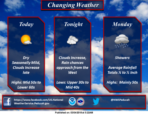
Departing High pressure will yield one more nice weather day today, before letting clouds increase tonight, as rain sets in to start the new work week. (NWS Paducah)

Seven Day Forecast

Today
Sunny, with a high near 57. East southeast wind 5 to 10 mph.
Tonight
Showers likely after midnight. Mostly cloudy, with a low around 40. East southeast wind 7 to 11 mph. Chance of precipitation is 70%.
Monday
Showers. High near 52. East southeast wind 9 to 14 mph becoming south in the afternoon. Winds could gust as high as 21 mph. Chance of precipitation is 90%.
Monday Night
A 30 percent chance of showers before midnight. Mostly cloudy during the early evening, then gradual clearing, with a low around 36. South southwest wind 5 to 9 mph becoming west in the evening.
Tuesday
Mostly sunny, with a high near 53. West southwest wind 8 to 18 mph, with gusts as high as 26 mph.
Tuesday Night
A slight chance of rain showers, mixing with snow after 11pm, then gradually ending. Mostly cloudy, with a low around 31. West wind 11 to 14 mph, with gusts as high as 21 mph. Chance of precipitation is 20%.
Wednesday
Partly sunny, with a high near 41. Northwest wind 11 to 14 mph, with gusts as high as 25 mph.
Wednesday Night
Widespread frost after 11pm. Otherwise, partly cloudy, with a low around 25. Northwest wind 5 to 10 mph.
Thursday
Widespread frost before 7am. Otherwise, mostly sunny, with a high near 42. West northwest wind 7 to 11 mph.
Thursday Night
Widespread frost after 1am. Otherwise, partly cloudy, with a low around 27. West northwest wind 5 to 7 mph becoming light and variable.
Friday
Widespread frost. Otherwise, mostly sunny, with a high near 49. South wind 5 to 9 mph.
Friday Night
A chance of showers. Mostly cloudy, with a low around 36. South wind 8 to 10 mph.
Saturday
A chance of showers. Partly sunny, with a high near 57. South wind around 9 mph.

Flood Warning Continues for the Big Muddy

…The flood warning continues for the following rivers in Illinois… Big Muddy River near Plumfield and Murphysboro .

The Big Muddy River at Plumfield and Murphysboro will continue to fall into next week. Minor flooding is ongoing at Plumfield and is forecast to fall below flood stage by midday tomorrow. Moderate flooding is ongoing at Murphysboro and is forecast to fall below flood stage by Thursday night.

PRECAUTIONARY/PREPAREDNESS ACTIONS… SAFETY MESSAGE… Never drive cars…trucks or sport utility vehicles through flooded areas. The water may be too deep to allow safe passage. Never allow children to play in or near flood waters. Stay tuned to NOAA Weather Radio or your local media for further statements and possible updated forecasts.

Hazardous Weather Outlook

This Hazardous Weather Outlook is for portions of southern Illinois, southwest Indiana, western Kentucky, and southeast Missouri. .
DAY ONE…Today and Tonight Flood warnings continue. Reference the warnings and statements for details.

.DAYS TWO THROUGH SEVEN…Monday through Saturday Continuing flooding and details thereof may be referenced via the latest warnings and statements.

Frost is expected Wednesday night and Thursday night, when Lows are forecast in the 20s.

.SPOTTER INFORMATION STATEMENT… Spotter activation is not anticipated at this time.

Print Friendly, PDF & Email

Speak Your Mind

Benton, West Frankfort, Illinois News | Franklin County News