by Steve Dunford
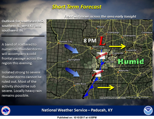 There is a line of Thunderstorms that are crossing the Mississippi as we speak. They are slow moving in front of an advancing cold front toward the area. Small hail and wind gust up to 40 mph have been reported with these storms. They are below severe limits.
The first round this morning brought some much needed relief to the dry conditions. Radar generated rain totals from around the county go from .3″ near Zeigler and Royalton, .6″ around Christopher one inch around Benton Sesser and West Frankfort, pockets of 1.5″ around Thompsonville, to over 2″ northeast of Ewing.
The Storm Prediction Center still has us placed under a moderate risk (level 1 or 5) for the risk of damaging thunderstorm winds. The SPC was eying Southern Illinois for the possibility of issuing a Severe Thunderstorm Watch.
I look for a few significant weather advisories to be issued and maybe one or two Severe Thunderstorm Warnings to be issued.
I will be monitoring the storms as they approach. I will try to post statements on the website. However, I will keep the Facebook page updated frequently during any severe weather event.
I am trying to tweak how I do things. I have only posted the forecast here lately if there is a change. I am going to go back to doing it on a daily basis again. The Hazardous Weather Outlook and the seven day forecast are posted below.
Hazardous Weather Outlook
This Hazardous Weather Outlook is for portions of southern
Illinois, southwest Indiana, western Kentucky, and southeast
Missouri.
.DAY ONE…Today and Tonight
The Storm Prediction Center continues to outlook a marginal risk
of severe thunderstorms this afternoon and evening, particularly
from 3 to 8 p.m. Damaging wind is the primary severe weather
concern, with a limited risk for large hail. Storm hazards will
also include lightning and heavy rain.
.DAYS TWO THROUGH SEVEN…Wednesday through Monday
A chance of thunderstorms is forecast for all or a portion of the
region late Saturday night through Sunday night. Locally heavy
rainfall and lightning will be the primary concerns.
.SPOTTER INFORMATION STATEMENT…
Spotter activation is possible this afternoon and evening,
especially across southeast Missouri and southern Illinois.
Seven Day Forecast
This Afternoon
Showers and thunderstorms likely. Mostly cloudy, with a high near 81. South southeast wind around 6 mph. Chance of precipitation is 60%.
Tonight
Showers and thunderstorms likely, mainly before 10pm. Mostly cloudy, with a low around 52. South southwest wind 5 to 9 mph becoming west in the evening. Chance of precipitation is 70%.
Wednesday
Partly sunny, with a high near 68. West wind around 8 mph.
Wednesday Night
Mostly cloudy, with a low around 54. Northwest wind around 5 mph becoming calm in the evening.
Thursday
Partly sunny, with a high near 73. Light and variable wind.
Thursday Night
Mostly clear, with a low around 54. Light south southeast wind.
Friday
Sunny, with a high near 81. Calm wind becoming south 5 to 7 mph in the morning.
Friday Night
Mostly clear, with a low around 59. South wind around 5 mph.
Saturday
Mostly sunny, with a high near 86. South wind 5 to 8 mph.
Saturday Night
Mostly clear, with a low around 65. South wind around 8 mph.
Sunday
A chance of showers and thunderstorms. Partly sunny, with a high near 78. South southwest wind 9 to 11 mph becoming west northwest in the afternoon.
Sunday Night
A slight chance of showers and thunderstorms. Partly cloudy, with a low around 48. Northwest wind 6 to 8 mph.
Monday
Sunny, with a high near 69. North northwest wind around 7 mph.


Speak Your Mind
You must be logged in to post a comment.