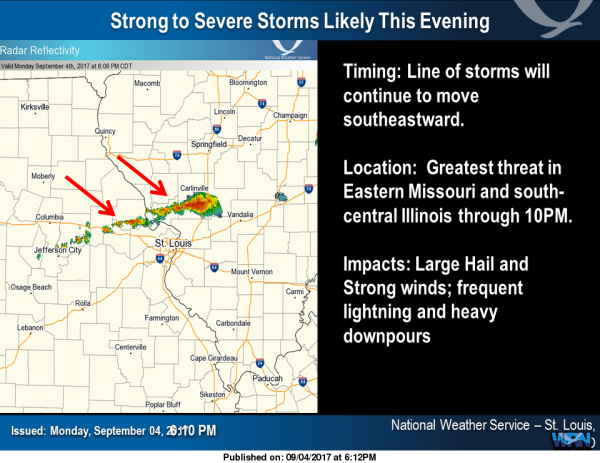
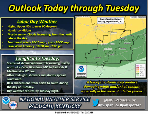
Labor Day feels like the 4th of July….Severe Thunderstorms…then October weather the remainder of the week.

by Steve Dunford

There is a slight risk (level 2 of 5)  of severe weather mainly for the overnight hours for the north part of Southern Illinois, including Franklin County .  The rest of the region is under a marginal risk (level 1 of 5)

The Storm Prediction Center claims the biggest threat is from damaging winds.  There is a minor threat of large hail.  The tornado threat is near zero.

One thing I am keeping an eye on is the enhanced risk (level 3 of 5) of severe weather keeps getting closer to our region.  Two hours ago, it was just a sliver into Indiana.  Now it is from a Mattoon to Kankakee line and east.

I will be up tonight until the severe threat is over.  If a watch is issued, I will declare an emergency alert day for the website.  My main focus will be covering the severe weather event.  I will be sharing things from all three of the TV stations in this market, from the National Weather Service and Franklin County Emergency Management Agency.

Because of how fast information can come in, monitor the website’s Facebook page.  The main focus will be Franklin County in events.  There will be a significant focus on the six surrounding counties, as the page has been reaching into those markets.  There will be an eye kept though, on all the counties from I-64 south.

If you have the day off enjoy it, and take one last dip in the pool.

Here are the advisories in effect and the seven day forecast for Franklin County.

Lake Wind Advisory

…LAKE WIND ADVISORY REMAINS IN EFFECT UNTIL 7 PM CDT THIS
EVENING…

* TIMING…Winds will increase this morning, peaking this
afternoon. Winds will decrease toward sunset. The strongest
winds will be over southwest Indiana and adjacent portions of
Illinois and Kentucky this afternoon.

* WINDS…Peak gusts will be 20 to 30 mph, especially over
southwest Indiana and adjacent portions of Illinois and
Kentucky this afternoon. |

* IMPACTS…Holiday recreational activities, especially boating,
will be the most impacted. Choppy and increasingly hazardous
wave conditions will develop. Long fetches of south to north
oriented lakes and rivers will be most impacted.

PRECAUTIONARY/PREPAREDNESS ACTIONS…

A Lake Wind Advisory indicates that winds will cause rough chop
on area lakes. Small boats will be especially prone to capsizing.

Hazardous Weather Outlook

This Hazardous Weather Outlook is for portions of southern
Illinois, southwest Indiana, western Kentucky, and southeast
Missouri.

.DAY ONE…Today and Tonight

Thunderstorms are forecast Tonight and Tuesday. There is a Slight
Risk of severe thunderstorms across northern parts of southern
Illinois and southwest Indiana. Otherwise, a few strong to severe
storms will be possible tonight. Gusty and potentially damaging winds,
frequent lightning and locally heavy rain may accompany the
stronger storms.

Minor flooding is forecast on parts of the Green River. See the
latest river flood warning products for details.

.DAYS TWO THROUGH SEVEN…Tuesday through Sunday

No hazardous weather is expected at this time.

.SPOTTER INFORMATION STATEMENT…

Spotter activation may be requested tonight.

Seven Day Forecast

Labor Day
Sunny, with a high near 90. Southwest wind around 16 mph, with gusts as high as 23 mph.
Tonight
A 50 percent chance of showers and thunderstorms, mainly after 8pm. Mostly cloudy, with a low around 64. South southwest wind 5 to 8 mph becoming light and variable.
Tuesday
A 20 percent chance of showers and thunderstorms before 10am. Partly sunny, with a high near 76. Northwest wind 5 to 8 mph.
Tuesday Night
Mostly clear, with a low around 51. North northwest wind 3 to 6 mph.
Wednesday
Sunny, with a high near 72. Light northwest wind becoming north northwest 5 to 9 mph in the morning.
Wednesday Night
Mostly clear, with a low around 49. North northwest wind around 6 mph becoming calm in the evening.
Thursday
Sunny, with a high near 73. Calm wind becoming northwest 5 to 7 mph in the morning.
Thursday Night
Mostly clear, with a low around 50. North northwest wind around 5 mph becoming calm in the evening.
Friday
Sunny, with a high near 74. Calm wind becoming north around 5 mph in the afternoon.
Friday Night
Mostly clear, with a low around 50. Light east wind.
Saturday
Sunny, with a high near 74. East wind 3 to 6 mph.
Saturday Night
Mostly clear, with a low around 52. East northeast wind 3 to 5 mph.
Sunday
Sunny, with a high near 75. East northeast wind 5 to 7 mph.


Two car accident in the southbound lane just north of the Benton Exit

By Steve Dunford

BENTON, IL-  There has been a two car accident involving a pickup truck and a camper just north of the 71 mile marker on I-57 southbound .  This happened just after noon today.

Reports on Social Media claim that traffic is backed up at the Sesser exit.  Please use an alternate route and be aware that Route 37 could be congested.

Benton and West City fire departments responded as well as Abbott EMS.

Information from Southern Illinois Fire Incidents and Southern Illinois Fire Dispatch provided to this story.

FRANKLIN HOSPITAL OFFERING FREE DIABETIC SCREENING DAY

By Derek Johnson – Chief Operating Officer, Franklin Hospital 

Franklin Hospital will be offering a Diabetic Screening Day from 7 a.m. to 11 a.m. Friday, September 8, 2017 in Franklin Hospital’s First Floor Conference Room. The purpose of the screening is to promote education and care for diabetics and/or those at risk for diabetes. The screening is FREE and open to the public, no appointment necessary.

The FREE tests offered are HA1c, Creatinine/GFR, Glucose, and Microalbumin urine. The HA1c provides the average glucose levels of blood glucose over the previous three months. The Creatinine/GFR (Glomerular Filtration Rate) check how the kidneys are functioning. The Glucose test measures blood sugar levels and the Microalbumin urine test is used to detect early signs of kidney damage in people that are at high risk for developing kidney disease. All tests are FREE and do not require fasting.

If you have a glucometer and would like to get it tested, Franklin Hospital laboratory staff members will be conducting glucometer verification testing. Free blood pressure checks will also be offered, and, hospital staff will be performing home blood pressure meter verification.
Podiatrist Dr. Christopher Moore from Southern Illinois Foot and Ankle Clinic will be available at the clinic to answer questions about diabetes and how it can affect feet and lower legs. Registered Dietician, Janet Porter, will be available to discuss healthy eating habits and proper nutrition for diabetics.

Franklin-Williamson Bi-County Health Department personnel will be on-site to discuss the newly formed Franklin County Diabetic Support Group. The group will hold is initial meeting from 1:30 to 3:00 p.m. on Wednesday, September 27, 2017 in Franklin Hospital’s First Floor Conference Room.

Franklin Hospital’s FREE Diabetic Screening Day is being funded by a grant from the Illinois Critical Access Hospital Network.

For questions about the Diabetic Screening Day call Judy Courter, Laboratory Director, at 618-439-3161, Ext. 357.

Z-R Girls Jr. High Softball wins at Sesser-Valier, Fall to Hamco on Friday

by Steve Dunford

The Zeigler-Royalton girls softball team beat Sesser-Valier on Wednesday of last week.  I am unsure of the final.  Haley Pasquino fanned 15 in the game.

Allison Giles and Olivia Kirkpatrick went 3-5 at the plate on the afternoon, Bella Bate 2-3, Skylar Hudson 2-4  Lainey Morris, Olivia Crain, Hadley Sweetin, and Pasquino picks up hits for the Tornadoes.

On Friday, Z-R travels to McLeansboro to face the Hamilton County Foxes, and fall 7-6.   Hudson leads the offense that day going 3-4, Giles, Harris, Crain, and Sweetin end up 2-4 at the plate.  Pasquino goes 1-2 with a walk and a sacrifice.

Z-R is 5-6 on the season.

MVFC Weekly Notebook

From Mike Kern, Associate Commissioner, Missouri Valley Football Conference

Best in the FCS

The MVFC is well represented on national pre-season rankings/player recognition lists. The Conference has an FCS-best five teams on the FCS coaches poll; an FCS-best six teams on the STATS FCS top-25 poll; an FCS-best five student-athletes on the STATS Buck Buchanan Award Watch List; an FCS-best 17 student-athletes on the STATS FCS pre-season All-America teams, which includes an FCS-best seven individuals on the first-team unit. South Dakota State, meanwhile, has an FCS-best three student-athletes on the STATS Walter Payton Award Watch List (TE Dallas Goedert, QB Taryn Christion, and WR Jake Wieneke).

Against the FBS
MVFC schools set a league record with four wins against FBS schools last year. Three MVFC games this weekend are at FBS sites. The Conference has had at least one FBS win in each of the last seven seasons.

Home Sweet Home
Last year, MVFC schools recorded a 16-4 record in home non-conference games. In the last eight seasons (since 2009), MVFC schools have combined for a 131-17 (.885) record in games played at MVFC sites.

Special Weather Statement issued about dense fog this morning

Remnants of Tropical Storm Harvey on its way

The remnants of Tropical Storm Harvey will be reaching the area Thursday night.  It should exit the area on Sunday morning.  There is a chance of heavy rain and could influence high school football.

At this time, nothing severe is in the forecast.  There could be some heavy rain and moderate wind with this.  I will keep you posted as the system gets closer.  – Steve

Special Weather Statement

…PATCHY DENSE FOG POSSIBLE…

PATCHES OF DENSE FOG MAY BE LOCALLY DENSE EARLY THIS MORNING. THIS
WILL BE ESPECIALLY TRUE FOR PARTS OF SOUTHEAST MISSOURI AND
SOUTHWEST ILLINOIS…BUT IS ALSO POSSIBLE IN WESTERN KENTUCKY AND
SOUTHWEST INDIANA.

IF YOU ARE TRAVELING…BE PREPARED AND DRIVE SLOWLY AND WITH YOUR
LOW BEAM HEADLIGHTS ON…IF YOU ENCOUNTER AN AREA WHERE FOG IS
RESTRICTING VISIBILITY.

THE FOG SHOULD LIFT BY MID MORNING.

Hazardous Weather Outlook

.DAY ONE…Today and Tonight

Patchy fog may be locally dense at times early this morning,
mainly across parts of southeast Missouri and southwest Illinois.


.DAYS TWO THROUGH SEVEN…Wednesday through Monday

The primary long term storm hazard is heavy rain and flooding from
Harvey and its influence, and this chance will peak on Friday into
Saturday with the best and heaviest rains expected. Maximum areal
average rainfall totals by the end of the event on Sunday could
range from 2 to 3 inches in the north, along the Interstate 64
corridor, to 4 to 6 inches in our south, nearest the Missouri
Bootheel. These totals and areal placements will likely change
over time, as it is too far out in time right now to get specific
beyond these general first and best estimate ranges.

.SPOTTER INFORMATION STATEMENT…

Spotter reports of rain and wind will be helpful as Harvey
becomes more of an influence during the middle and latter part of
the week.

Seven Day Forecast

Today
Patchy fog before 8am. Otherwise, partly sunny, with a high near 82. Calm wind becoming north northwest around 5 mph in the afternoon.
Tonight
Partly cloudy, with a low around 63. Light north northeast wind.
Wednesday
Partly sunny, with a high near 83. Calm wind becoming northeast around 5 mph in the morning.
Wednesday Night
Mostly cloudy, with a low around 64. Northeast wind 3 to 5 mph.
Thursday
A 20 percent chance of showers and thunderstorms before 1pm. Partly sunny, with a high near 82. Northeast wind 3 to 8 mph.
Thursday Night
A slight chance of showers, then a chance of showers and thunderstorms after 1am. Mostly cloudy, with a low around 64. Northeast wind around 6 mph. Chance of precipitation is 30%.
Friday
Showers likely and possibly a thunderstorm. Mostly cloudy, with a high near 77. East northeast wind around 9 mph. Chance of precipitation is 70%.
Friday Night
Showers likely and possibly a thunderstorm before 1am, then a chance of showers and thunderstorms after 1am. Mostly cloudy, with a low around 64. East northeast wind 6 to 8 mph.
Saturday
A chance of showers and thunderstorms. Mostly cloudy, with a high near 80. East northeast wind around 6 mph becoming southeast in the afternoon.
Saturday Night
A slight chance of showers and thunderstorms. Mostly cloudy, with a low around 64. Light and variable wind.
Sunday
A chance of showers and thunderstorms. Mostly sunny, with a high near 84. Light and variable wind becoming north northeast around 5 mph in the morning.
Sunday Night
Partly cloudy, with a low around 65. West wind around 5 mph becoming calm in the evening.
Labor Day
Mostly sunny, with a high near 84. Southwest wind 3 to 7 mph.


Bearcats take three games over the weekend in Junior High Softball

by Steve Dunford

The Christopher Junior High girls win three in a row over the weekend.  In the first game of three on Friday, they beat Sesser-Valier Red Devils 7-3.   Amiah Hargrove and Cortney Park go 3-4 from the plate, both have in doubles.  Hanna Burzynski goes 2-3, and Regan Gilbert goes 2-4 with an RBI.

The Bearcats play a DH on Saturday.  In game one, Mackensie Jackson goes 4-5 at the plate as the Bearcats defeat the Trico Pioneers, 13-2.

Makayla Dejaer was 3-5, Courtney Parke was 3-4 with 3 RBIs  Amiah Hargrove goes 2-2 with three walks driving in four.

Tori Crain was 2-4 on the afternoon with an RBI.   RyAnn Clark, Reagan Gilbert, Hannah Burzynski  pick up base hits. with Clark driving in two.

In the second game of the afternoon Amiah Hargrove goes a perfect 4-4 at the plate and drives in four runs, as Chirstopher defeats the Chester Yellowjackets 9-1.  Malayala Dejear, Addison Furlow, and Tori Crain, all pick up two hits for the Bearcats.  Amila Ahner picks up a hit as well.

Christopher improves to 6-3 and is playing at home against Unity Point now.


Showers and thunderstorms across the area this afternoon

by Steve Dunford

I went ahead and shared this information in case you have plans for outdoor activities this afternoon.

There is a cell with heavy rain getting ready to cross the Mississippi in Perry County, Mo.  I am going to add a lightning detector in the future, but as intense as the cell is, there might be some cloud to ground lightning in it.  The storms are not severe.

The showers should clear off by early morning.  There is going to be three very mild days ahead, and a chance of storms by the weekend.

UPDATE:  3:30 p.m.  The showers and thunderstorms that I was keeping an eye on are weakening.  The cell was in Western Perry county a half hour ago and fell apart.  There are still some light to moderate showers in SEMO.  They are weakening as well.


Off and on showers today…..mild pattern continues for most of the work week

Chance of  showers and thunderstorms on Friday, it could play havoc with football Friday night

Scattered showers and thunderstorms will continue through tonight. Thunderstorms will be mostly during the afternoon and evening hours. A weak front will become nearly stationary across southern Illinois and extreme west Kentucky today and tonight. Highs will be mainly in the lower 80’s. Lows tonight will be 60 to 65. (NWS Paducah)

Hazardous Weather Outlook

This Hazardous Weather Outlook is for portions of southern
Illinois, southwest Indiana, western Kentucky, and southeast
Missouri.

.DAY ONE…Today and Tonight

Scattered thunderstorms are expected today and tonight, mainly
during the afternoon and evening hours. The main hazards will be
lightning and heavy rain.

.DAYS TWO THROUGH SEVEN…Tuesday through Sunday

A chance of thunderstorms is forecast over all or a portion of the
area Thursday through Sunday. Heavy rainfall and lightning will be
the primary concerns.

.SPOTTER INFORMATION STATEMENT…

Spotter activation is not anticipated at this time.

Seven Day Forecast

Today
Scattered showers and thunderstorms. Partly sunny, with a high near 81. Light and variable wind becoming northwest around 6 mph in the afternoon. Chance of precipitation is 40%.
Tonight
A slight chance of showers and thunderstorms. Partly cloudy, with a low around 62. Light north northeast wind. Chance of precipitation is 20%.
Tuesday
Mostly sunny, with a high near 81. Calm wind becoming north northwest around 5 mph in the afternoon.
Tuesday Night
Partly cloudy, with a low around 62. Light north wind.
Wednesday
Mostly sunny, with a high near 82. Calm wind becoming north northeast around 5 mph in the afternoon.
Wednesday Night
Partly cloudy, with a low around 64. Light east northeast wind.
Thursday
Partly sunny, with a high near 83. Calm wind becoming northeast around 6 mph in the afternoon.
Thursday Night
Mostly cloudy, with a low around 63. East northeast wind around 6 mph.
Friday
A chance of showers and thunderstorms. Partly sunny, with a high near 81. East northeast wind 6 to 8 mph.
Friday Night
A chance of showers and thunderstorms. Mostly cloudy, with a low around 64. East wind 3 to 7 mph.
Saturday
A chance of showers and thunderstorms. Partly sunny, with a high near 83. Light and variable wind becoming south southeast around 6 mph in the morning.
Saturday Night
A slight chance of showers and thunderstorms. Mostly cloudy, with a low around 65. South southwest wind 3 to 5 mph.
Sunday
A slight chance of showers and thunderstorms. Partly sunny, with a high near 84. Southwest wind 3 to 6 mph.


The 2017 Christopher-Zeigler-Royalton Bearcats

by Steve Dunford

C-Z-R Roster

3 Landen Bate 5’10” 160 QB/DB 9
7 Triston Shively 5’9″ 150 RB/LB 9
8 Austin Wampler 5’8″ 120 WR/DB 10
11 Gabriel Motsinger 5’11” 160 WR/DB 10
12 Bryce Pratt 6’3″ 175 QB/DB 10
15 Caleb Davis 5’7″ 147 RB/LB 9
16 Dustin Richard 5’10” 140 WR/DB 10
20 Grant Shaffer 5’7″ 146 QB/DB 10
21 Jason Cole 5’10” 140 RB/DB 11
22 Josh Davis 6’0″ 170 RB/MLB 10
26 Garrett Vanfossan 6’0″ 145 WR/DB 11
28 Trinton Bishop 6’0″ 160 WR/DB 12
30 Jeremiah Bright 5’10” 180 DB/LB 11
32 Dalton Humphrey 5’9″ 185 LB/RB 10
33 Greg Fletcher 6’0″ 170 TE/LB/QB 10
42 Chris Lane 5’7″ 145 RB/LB 11
52 Darrick Leiser 5’8″ 235 OL/DL 11
53 Scotty Killip 5’6″ 160 OL/DL 12
61 Camden Kirkpatrick 6’2″ 200 OL/DL 11
62 Christian Shadowens 6’0″ 205 K/OL/DL 11
65 Ryan Helfrich 6’2″ 190 OL/DL 11
68 Frankey Rebolledo 5’10” 180 OL/DL 11
70 Ryan Bond 5’11” 300 OL/DL 10
73 Gavin Jay 5’10” 170 OL/DL 11
74 Gannon Dollins 6’4″ 200 OL/DL 9
75 Zack Marvel 6’2″ 240 OL/DL 12
76 Adrian Ratajczyk 6’0″ 277 OL/DL 9
78 Aaron Abrahamsen 6’2″ 250 OL/DL 11
86 Noah Hervey 6’1″ 175 WR/LB 11
88 Cole Gelso 6’0″ 200 TE/LB 9

C-Z-R Schedule

Nickname: Bearcats
Head Coach: Anthony Hargrove
2016 Record: 0-9
2017 Classification Enrollment: 414.00

Aug 25 7:00 H Vienna [V.-Goreville Coop] 548.00
Sep 1 7:00 H Carmi (C.-White County) 370.00
Sep 8 7:00 A Fairfield 423.00
Sep 15 7:00 A Albion (Edwards County)  280.00
Sep 22 7:00 A Sesser (S.-Valier) [Coop] 488.00
Sep 29 7:00 H Eldorado 358.00
Oct 6 7:00 A Johnston City 334.00
Oct 13 7:00 H Chester 311.00
Oct 20 7:00 A McLeansboro (Hamilton County) 376.00

Link to WSIL Sports Extra Preview

http://www.wsiltv.com/story/36122570/bearcats-ready-to-hit-in-first-full-pads-practice

Link to the story in the summer where Anthony Hargrove was hired as coach

Former NFL DE Anthony Hargrove takes over as C-Z-R head coach

As stated above, Anthony Hargrove has taken over as head coach of the Bearcats.  He was the defensive coordinator last season, and has been very active in establishing a junior high program in the community.

Even though the Bearcats were 0-9 last season, there is a good crop of sophomores coming up from Christopher and Zeigler-Royalton has a very talented freshman class coming in.  You can see several freshmen dotted along the varsity roster.

The three sport athletes of QB Bryce Pratt and RB/WR Gabriel Motsinger should lead the Bearcat offense.  At the freshman level, the Bearcats had a great year, either 7-2 or 6-3.

Pratt picked up some varsity experience against Vienna-Goreville last year, and held his own.

Tonight, this is a winnable game for the Bearcats.  There could be some week 10 football in the future with this young team.  I am going to put their record this season around the 3-6 mark.


Benton, West Frankfort, Illinois News | Franklin County News