Benton Council nixes Harrison mural painting

http://www.bentoneveningnews.com/news/20170712/benton-council-nixes-harrison-mural-painting

BENTON, IL  –  (Rick Hayes, Benton News.  Please Click on the link for the full story.  Here is an excerpt below.)

Reasoning that it has no economic benefit to the city, Benton City Council members on Monday nixed the idea of a proposed Beatles-themed mural near Interstate 57.

John Cerney of Salinas, Calif., had entertained the idea of painting the 16-foot mural depicting George Harrison and his fans on city-owned property between airport property and the interstate.

“He chose Benton to donate his art for one year. He chooses somewhere across the country every year,” Rachel Gartner, the city’s public information coordinator, said at a council meeting two weeks ago. “He is interested in the story behind George Harrison visiting his sister (Louise) here.”

Marginal risk for Severe Weather for Route 13 South

by Steve Dunford

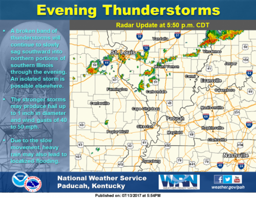
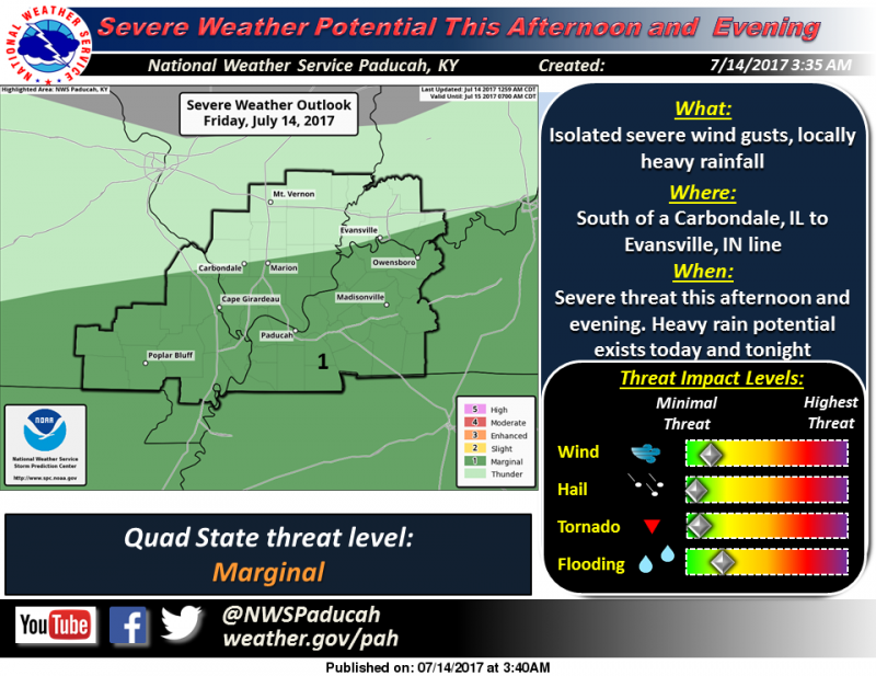
We had two rounds of a couple pretty heavy showers and thunderstorms that crossed the region last night.  There was a few reports of limbs down across Franklin County.

There is a marginal (level one of five) risk for severe thunderstorms for this afternoon and evening south of a Carbondale to Evansville, IN line.

As far as precipitation for the next few hours, there is a line of storms that are stretching from Clinton County through Northern Marion County at this time.  They are drifting ESE.  If they stay together, they can bring some showers and possible rumbles of thunder to Franklin county.

Below is the Hazardous Weather Outlook and the seven day forecast for Franklin County.


This Hazardous Weather Outlook is for portions of southern
Illinois, southwest Indiana, western Kentucky, and southeast
Missouri.

.DAY ONE…Today and Tonight

There is a marginal risk of severe weather this afternoon and
evening south of a line from Carbondale,IL to Evansville, IN.
Isolated severe wind gusts are possible.

Locally heavy rainfall is possible today and tonight across the
entire area. Flooding of low lying or poor drainage locations are
possible.

.DAYS TWO THROUGH SEVEN…Saturday through Thursday

Thunderstorms are possible Saturday over southern Missouri and
southern Kentucky. Severe storms are not expected, but locally
heavy rainfall is possible.

Thunderstorms are possible along the I-64 corridor on Thursday.
Severe storms are not expected at this time.

Heat index values on Tuesday, Wednesday, and Thursday afternoons
will range from 100 to 105 over much of the area.

.SPOTTER INFORMATION STATEMENT…

Spotters may be activated at isolated locations this afternoon and
evening.

Seven Day Forecast for Franklin County

Today
Scattered showers and thunderstorms before 3pm, then isolated showers and thunderstorms after 5pm. Partly sunny, with a high near 87. North wind 3 to 5 mph. Chance of precipitation is 40%.
Tonight
Mostly cloudy, with a low around 67. Light north northeast wind.
Saturday
Sunny, with a high near 84. North wind 3 to 5 mph.
Saturday Night
Mostly clear, with a low around 64. Light northeast wind.
Sunday
Sunny, with a high near 89. Calm wind becoming north northwest around 5 mph in the afternoon.
Sunday Night
Mostly clear, with a low around 67. Light and variable wind.
Monday
Sunny, with a high near 89. Light and variable wind.
Monday Night
Mostly clear, with a low around 69. Light and variable wind.
Tuesday
Sunny, with a high near 92. Light and variable wind.
Tuesday Night
Mostly clear, with a low around 71. Light and variable wind.
Wednesday
Sunny, with a high near 93. Light south southwest wind.
Wednesday Night
Mostly clear, with a low around 73. Light south wind.
Thursday
Mostly sunny, with a high near 94. Southwest wind 3 to 6 mph.


Franklin County fire departments have a busy night

by Steve Dunford

WSIL – TV photo

BENTON and WEST FRANKFORT IL-  There were two major fires in the county overnight, one in Benton and the other in West Frankfort.  Both were MABAS box alarms and there were injuries at each.  The incidents were less than two hours apart.

At 1:37 a.m. Benton firefighters were toned to a structure fire on 1203 E Bond street.  West City, West Frankfort, Christopher, and Sesser fire departments  were called to the scene for Mutual Aid.

Original repots say the fire was contained to the attic, but Benton fire was toned back to the scene at 6:37 a.m. for a rekindle.

At 3:18 a.m. West Frankfort firefighters were toned to the 100 block of West 5th street for a structure fire that was described as having major fire showing.  Johnston City, Benton, Marion, Zeigler, and West City departments were called for mutual aid.

There were two residents as well as one firefighter injured at the scene.

In two other incidents, Benton Firefighters were called to 1107 N McLeansboro street at 7:17 last night, for a tree on a residence.

Around 7:00 a.m. this morning, West Frankfort firefighters were called to the Anna Gray High Rise, for a malfunctioning smoke detector on the third floor, of a vacant apartment.

I will try to contact Benton and West Frankfort fire officials with additional information on the structure fires this afternoon.

Information from WSIL-TV, Southern Illinois Fire Incidents, Southern Illinois Fire Dispatch, and the Zeigler Fire Department contributed to this story.


Illinois Department of Insurance Reminds Homeowners of Their Options Following Summer Storms

Press release from the Illinois Department of Insurance

SPRINGFIELD – Following severe summer storms, the Illinois Department of Insurance (DOI) wants Illinois families to know the range of options they have when it comes to their homeowners insurance.

How can I make sure I have the correct homeowners insurance?

Consumers should re-evaluate their risk profile at least once a year to ensure their homeowners policy provides the protection they need. Questions to consider include:

• Am I now at risk?
• Are tornadoes now a threat?
• Do I need a flood insurance policy or sewer backup coverage?
• What has changed in my home?
• Did the number of people (and belongings) increase or decrease?
• Have I made any major purchases?
• Have I updated my home with a kitchen renovation, new security system or other improvements?
• Should I be looking at different coverage?
• Can I save money by bundling my home and auto insurance?

I thought I was covered but I’ve learned that I’m not.

Coverages: Most homeowners insurance policies provide a package of coverages. The main types of coverage are described below. Keep in mind that you’re covered only if the loss is caused by a peril your policy covers. For example, if your home becomes unlivable due to an earthquake and your homeowners policy doesn’t cover earthquakes, your policy won’t pay for loss of use of your home. Review your policy for the limits of your coverage.

• Dwelling. Pays for damage to your house and to structures attached to your house. This includes damage to fixtures, such as plumbing, electrical wiring, heating and permanently installed air-conditioning systems.
• Other Structures. Pays for damage to fences, tool sheds, freestanding garages, guest cottages and other structures not attached to your house.
• Personal Property. Reimburses you for the value of your possessions, including furniture, electronics, appliances and clothing, damaged even when they aren’t on your property, such as those at an off-site storage locker or with your child at college.
• Loss of Use. Pays some of your additional living expenses while your home is being repaired.
• Personal Liability. Covers your financial loss if you are sued and found legally responsible for injuries or damages to someone else.
• Medical Payments. Pays medical bills for people hurt on your property or hurt by your pets.
• Peril is an insurance term for a specific risk or reason for a loss. Some policies cover all perils except ones specifically excluded. At the other extreme are policies that cover only the perils named in the policy.

Endorsements/Additional Coverages:

Flood

Standard homeowners policies do not cover flood damage. However, if you have a flood insurance policy, your company or the National Flood Insurance Program (NFIP) will assign an adjustor to handle your claim. To contact NFIP call 800-638-6620.

If your home is not covered for flood damage, you should ask the representatives at the local disaster application center or the toll-free disaster tele-registration hotline (800-621-3362) if you are eligible for financial assistance.

Mine Subsidence

Standard homeowners policies do not cover damage due to mine subsidence unless you paid an additional premium for a mine subsidence endorsement.

Earthquake

Standard homeowners policies do not cover damage due to earthquakes unless you paid an additional premium for an earthquake endorsement. If you do not have earthquake insurance, any damage that can be directly attributed to the quake would not be covered.

If you purchased an earthquake coverage endorsement, your company will assign a representative to evaluate your damage. If you did not purchase earthquake coverage, you should ask the representatives at the local disaster application center or the toll-free disaster tele-registration hotline if you are eligible for financial assistance.

Homeowners insurance contracts generally have a stated deductible (e.g. $250) for claims such as fire and theft. The deductible for earthquake coverage is a stated percentage (e.g. 5%) of the amount of insurance you carry for each coverage under the policy.

If, for example, a homeowners policy provides $100,000 of coverage on the dwelling, $50,000 on the contents, and $10,000 on an unattached garage and the earthquake deductible is 5%, there would be an earthquake deductible of $5,000 on the dwelling, $2,500 on the contents and $500 on the unattached garage.

Since all insurance contracts are not the same, you should ask your insurance agent to review your policy and earthquake deductible.

If people still have questions about their coverage, DOI has developed a useful resource center at http://insurance.illinois.gov/HomeInsurance/consumerHomeowners.html. Should someone want to speak with DOI staff members, they can call 866-445-5346.

Congressman Mike Bost hosts tele-town hall July 18th

I need to hear from you! To give constituents the opportunity to share your concerns regarding issues before the United States Congress and the federal government, I will be hosting a tele-town hall meeting at 6:00 pm CT on Tuesday, July 18.

I will provide an update on health care reform, the economy, immigration, veterans, and any other issues you would like to talk about. I look forward to taking as many questions as our hour together allows. Sign up at bost.house.gov/participate.

NOTE:  I have participated in two of these.  It is well worth your time – Steve

Flood advisory for Perry County until 9:00 p.m.

The National Weather Service in Paducah has issued a

* Flood Advisory for…
Perry County in south central Illinois…

* Until 900 PM CDT

* At 601 PM CDT, Doppler radar indicated thunderstorms were
producing heavy rain over parts of the county. This will cause
minor flooding in the advisory area. As much as 2 to 3 inches of
rain have already fallen since mid afternoon, particularly from
the Pinckneyville area southeast to Du Quoin.

* Some locations that will experience flooding include…
Du Quoin, Pinckneyville, Tamaroa, Willisville, Cutler and St.
Johns.

Additional rainfall of an inch is expected over the area. This
additional rain will result in minor flooding.

PRECAUTIONARY/PREPAREDNESS ACTIONS…

Turn around, don`t drown when encountering flooded roads. Most flood
deaths occur in vehicles.

Excessive runoff from heavy rainfall will cause flooding of small
creeks and streams, country roads, farmland, and other low lying
spots.

Slow moving storms approaching Franklin County

Radar Update at 5:50 PM: A broken band of thunderstorms will continue to slowly sag southward into northern portions of southern Illinois through the evening. An isolated storm is possible elsewhere. The stronger storms may produce hail up to 1 inch in diameter and wind gusts of 40 to 50 mph. Due to the slow movement, heavy rain may lead to localized flooding as well.

Wreck on I – 57 Northbound near the I – 24 split

The Illinois State Police sent in the following traffic accident alert at 4:43 p.m., Thursday, July 13.

“All I-57 Northbound lanes are currently closed at milepost 44 ( just south of I-24) due to a crash involving three truck tractor / semi trailers.  It is anticipated that I-57 northbound will be closed for a significant amount of time for recovery and cleanup.  Northbound I-57 traffic is currently being diverted off of the interstate at Exit 30 (IL. Rt. 146). People traveling northbound on I-57 should use caution and seek an alternate route.

Updates will be provided as they are available.”

This subsequent update was sent in by the ISP at 5:04 p.m.

“Northbound I-57 traffic is now being diverted off the interstate at Exit 40.  Recovery crews are working to open one northbound lane just south of the I-24 split.”

CASA of Franklin County to host first annual Father Daughter dance

by Steve Dunford

BENTON, IL  –  CASA of Franklin County will host their first annual Father-Daughter dance on Saturday, August 5th at the Benton Civic Center.  The dance will be from 6:00 p.m. to 9:00 p.m.

CASA or Court Appointed Special Advocates, are there for abused and neglected children in court cases, especially to testify on their behalf.  This is a organization I strongly believe in.

I talked with Robin Frailey, the coordinator of the event. She said it does not have to be the father as the escort.  It could be a special man in a young lady’s life such as an uncle, grandfather etc.

The long time Akin Grade School teacher is busier than ever in her retirement years.  She told me that over 40 business in the county have helped monetarily, and there are some great things to bid on in a silent auction that night.  The items are shared below.

There will be a cotton candy machine and drinks that night for the young ladies.  There will be guy food as well.  There will be a live DJ that evening.

Tickets are $40.00 for a father/daughter, and $10.00 for each additional child.  You can obtain tickets by calling CASA of Franklin County at 438-0608, or calling Robin at 218-2805.  You can also visit their website at http://www.casafranklincounty.org/.  All tickets will be in advance.

I would like to encourage all you fathers to give a special young lady a treat that night, and help a good cause.

Silent auction items


Looking Back: Sesser took the brunt of a severe storm that went through the county one year ago today

by Steve Dunford

SESSER, IL –  I had my memories pop up on Facebook in the last few minutes  I was reminded that one year ago today, that Franklin County had a severe thunderstorm roll through that afternoon.

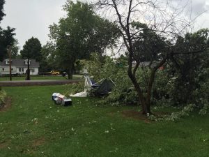
The brunt of the damage was in the Sesser Area.  I had several pictures of wind damage.  The picture is of d downed  tree in Jim and Carleen Roberts yard on the north side of the city.  It also shows pieces of their smashed produce stand .  Hopefully, I will be writing a story about their endeavors some time next week.

The posts from that afternoon came from my high school sports blog, Franklin County Hoops and Gridiron.  Since it is a dedicated group, I began to share emergency information on that site.

I was in frequent contact with Sesser Mayor Jason Ashmore that afternoon.  Not only Sesser, but most of the west side of the county experienced damage.  Valier was hit pretty hard as well.

Ameren-Illinois reported over 4,000 customers throughout power.  There was a brief power outage in West Frankfort, as 70 mph winds were clocked just to the west of town.

Benton, Thompsonville, as well as the rest of the east side of the county experienced little damage, as the cell began to weaken.

With a very small chance of severe weather today, pray we do not have a repeat.


Benton, West Frankfort, Illinois News | Franklin County News