
Second Act Eat & Educate: Helpful Pit Stops on the Road to Recov
July 18, 2017 By Leave a Comment
Press release from Southern Illinois Healthcare
Event Presenters:
Sue Odle, RN,MSN, Patricia Evans, RN,BSN, and Maria Cull, PT, DPT
This class will make you better prepared for any hospital recovery. As we all know, life is full of change. We can’t predict the future, but we can arm ourselves with knowledge. This class will discuss what a recovery journey may look like if you have broken bones, need wound treatment, IV therapy and more. It will address how you can best plan out your recovery. Join our team of experts from Upswing Recovery Care to take you through some helpful tips to get you home as fast as possible.
Event Cost:
$3 (includes complimentary lunch)
REGISTRATION REQUIRED: 877.480.4040
TIME AND LOCATION: Thursday, July 27th, from 12:00 pm to 1:30 p.m. at the SIH corporate headquarters, in the University Mall in Carbondale. (The former Elder-Beerman building.)
Severin to Hold Satellite Officer Hours July 24 – 28
July 18, 2017 By Leave a Comment
He will be at the Benton Public Library on Monday
Press release from State Representative Dave Severin
Marion…. State Representative Dave Severin (R- Benton) will be holding satellite office hours at several locations during the week of July 24th. Rep. Severin’s staff will be available to meet with constituents to address concerns and receive feedback on the issues most important to them. Dates, times, and locations for these office hours are:
Monday July 24th, Benton Public Library, 502 S Main St. in Benton, from 10:00 am – 1:00 pm..
Wednesday July 26th, Johnston City Hall, 100 West Broadway Blvd. in Johnston City, from 10:00 am – 12:00 pm.
Friday July 28th, McCoy Memorial Library, 118 S Washington St. in McLeansboro, from 11:00 am – 2:00 pm.
If you have any questions, please contact Rep. Severin’s District Office at (618) 440-5090 or through the contact form on his website at www.repseverin.com.
Harris new principal at FCHS
July 18, 2017 By Leave a Comment
by Steve Dunford
WEST FRANKFORT, IL – The Frankfort Community District School Board completed their administration team last night, by hiring Brock Harris as the new high school principal. Earlier, long time FCHS coach and science teacher Jory Dial was named as the district’s athletic director and assistant principal at the high school.
Harris is entering his second year with District 168. He was the principal at Frankfort Intermediate School last year. He came to West Frankfort from Webber Township High School in Bluford, where he was high school principal.
Before taking the position at Webber, he was a long time teacher, coach, and served a few years district’s AD at Thompsonville CUD #174. He lives in the T’ville area also.
If there were any other major personnel moves or action taken by the West Frankfort School Board last night, I will keep you updated.
Small chance of pop up storms this afternoon…..temps in the upper 90’s Thurs. through Sat
July 18, 2017 By Leave a Comment
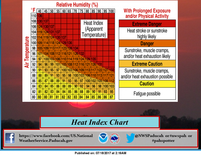
This may come in handy this week. It is important to understand that this chart is not for those who are out working or physically active in the full sun. The heat index chart takes the air temperature, shown on the column on the right side of the image, and the relative humidity, shown along the row on the top of the image to determine heat index values. As an example, we will use an air temperature of 92 degrees and a relative humidity value of 50%. To find the heat index value for the air temperature and relative humidity, look for the relative humidity value of 50% at the top of the chart. Go down the column until you reach the row corresponding to the air temperature of 92 degrees. The value inside of that square is 99 degrees. That is the expected heat index for the given air temperature and relative humidity. The Darker shading on the chart corresponds to the health impact of prolonged exposure and/or physical activity under those weather conditions. Dangerous and even deadly consequences can occur if you stay out too long in the summer heat, without taking precautions. Keep a watch on children, persons with serious health conditions, and pets during the summer heat. (NWS Paducah)
Hazardous Weather Outlook
National Weather Service Paducah KY
357 AM CDT Tue Jul 18 2017
.DAY ONE…Today and Tonight
Widely scattered thunderstorms are possible, with lightning,
locally heavy rain, and gusty winds the primary hazards.
The heat index will reach near 100 this afternoon.
.DAYS TWO THROUGH SEVEN…Wednesday through Monday
An Excessive Heat Watch is in effect for Wednesday through Sunday.
Refer to the Watch product for details.
.SPOTTER INFORMATION STATEMENT…
Spotter activation is not expected.
URGENT – WEATHER MESSAGE
National Weather Service Paducah KY
224 AM CDT Tue Jul 18 2017
…Conditions setting up for Dangerous Heat Wave Wednesday
through Sunday…
.As high pressure exerts increasing control over the mid
Mississippi river valley this week, expect a corresponding rise
in temperatures and humidity to dangerously high levels for our
area. Heat indices nudging to the triple digits will start to
show up today, and increase and become more commonplace in the 100
to 105 range through the remainder of the week and into the
weekend, offering our first prolonged duration heat event of the
summer.
…EXCESSIVE HEAT WATCH REMAINS IN EFFECT FROM WEDNESDAY
AFTERNOON THROUGH SUNDAY EVENING…
* TIMING…Wednesday afternoon through Sunday evening.
* HEAT INDEX VALUES…peaking near 105 degrees each afternoon.
* IMPACTS…The combination of hot temperatures and high
humidity will lead to an increased risk of heat related stress
and illness. The very young, the elderly, those without air
conditioning, and those participating in strenuous outdoor
activities will be the most susceptible. Also, car interiors
will reach lethal temperatures in a matter of minutes.
PRECAUTIONARY/PREPAREDNESS ACTIONS…
An Excessive Heat Watch means that a prolonged period of hot
temperatures is expected. The combination of hot temperatures and
high humidity will combine to create a dangerous situation in
which heat illnesses are possible. Drink plenty of fluids, stay
in an air conditioned room, stay out of the sun ,and check up on
relatives and neighbors.
Detailed Forecast
Today
A slight chance of showers and thunderstorms between 10am and 4pm. Mostly sunny, with a high near 91. Light and variable wind. Chance of precipitation is 20%.
Tonight
Mostly clear, with a low around 72. Calm wind.
Wednesday
Sunny, with a high near 94. Calm wind becoming west southwest around 5 mph in the morning.
Wednesday Night
Mostly clear, with a low around 74. Light south wind.
Thursday
Sunny and hot, with a high near 97. Southwest wind 3 to 6 mph.
Thursday Night
Mostly clear, with a low around 75. South southwest wind around 5 mph.
Friday
Sunny and hot, with a high near 97. Southwest wind 5 to 7 mph.
Friday Night
Mostly clear, with a low around 76. South southwest wind around 7 mph.
Saturday
Sunny and hot, with a high near 97. Southwest wind 6 to 9 mph.
Saturday Night
Partly cloudy, with a low around 75. South southwest wind 7 to 9 mph.
Sunday
A slight chance of showers and thunderstorms. Mostly sunny, with a high near 94. West southwest wind around 7 mph.
Sunday Night
A chance of showers and thunderstorms. Partly cloudy, with a low around 71. Southwest wind around 5 mph becoming northwest after midnight.
Monday
A chance of showers and thunderstorms. Partly sunny, with a high near 90. Northwest wind 5 to 7 mph.
Broadway Avenue in Johnston City will be closed Wed.-Thurs.
July 17, 2017 By Leave a Comment
From the Johnston City Police Department
TRAFFIC DETOUR: this Wednesday (7/19) and Thursday (7/20) Broadway Avenue will be shut down at the rail road tracks. The crossing is getting a complete replacement. Avoid this area and seek alternate routes.
Wreck on Southbound I 57 north of the Benton exit
July 17, 2017 By Leave a Comment
by Steve Dunford
Franklin County EMA is reporting traffic is congested north Exit 71 on Interstate 57 due to a traffic crash.
There have already been two minor incidents on the interstate this morning. One on the North Bound lanes south of Benton, and one near the Marion area.
Please take alternate routes, and as in incidents in the past, Route 37 will be backing up quickly.
I will provide further updates when they become available.
Valier High School “Blue Birds”
July 15, 2017 By Leave a Comment
http://www.illinoishsglorydays.com/id108.html
VALIER, IL – (Illinois High School Glory Days. Please click on the link above for the full story. Here is an excerpt below.,
Valier (population 662) is located along Il. Route 148 at Park Street Road in eastern Franklin County. This places Valier in the southern tip of Illinois about 25 miles northeast of Carbondale. The A, T & SF Railroad runs north and south through the west side of town. The east side of town is surrounded by two branches of Andy Creek.
Valier was established in 1905 and named after Albert and William Valier who owned the land on which the village was platted.
J.C. Stoffel (Class of 1943) provided the following facts about the organization of Valier High School:
Valier High School was organized for the 1925-26 school year:
1926-27 – This is the first school year to hold classes in the new high school building.
1927-28 – VHS became certified as a 4-year high school
1928-29 – First graduating class – 11 students
1965-66 – Last graduating class – 8 students
1928-29 thru 1941-42 classes – Average enrollment – 120.21
1942-43 thru 1965-66 classes – Average enrollment – 60.46
During 38 years of operation – Average enrollment – 82.47
