 Hazardous Weather Outlook
National Weather Service Paducah KY
331 AM CDT Fri Aug 4 2017
ILZ075>078-080>094-INZ081-082-085>088-KYZ001>022-MOZ076-086-087-
100-107>112-114-051000-
Jefferson-Wayne IL-Edwards-Wabash-Perry IL-Franklin-Hamilton-
White-Jackson-Williamson-Saline-Gallatin-Union-Johnson-Pope-
Hardin-Alexander-Pulaski-Massac-Gibson-Pike-Posey-Vanderburgh-
Warrick-Spencer-Fulton-Hickman-Carlisle-Ballard-McCracken-Graves-
Livingston-Marshall-Calloway-Crittenden-Lyon-Trigg-Caldwell-
Union KY-Webster-Hopkins-Christian-Henderson-Daviess-McLean-
Muhlenberg-Todd-Perry MO-Bollinger-Cape Girardeau-Wayne MO-Carter-
Ripley-Butler-Stoddard-Scott-Mississippi-New Madrid-
331 AM CDT Fri Aug 4 2017
This Hazardous Weather Outlook is for portions of southern
Illinois, southwest Indiana, western Kentucky, and southeast
Missouri.
.DAY ONE…Today and Tonight
Scattered thunderstorms will push out of west Kentucky this
morning. Locally heavy rainfall and lightning will be the primary
concerns.
.DAYS TWO THROUGH SEVEN…Saturday through Thursday
A chance of thunderstorms returns to the region late Saturday
night and continues over most of the region through Monday. The
best chances will be Sunday into Sunday night, when a few strong
to severe storms cannot be ruled out. Heavy rainfall and lightning
will be the most prevalent threats through the period.
Small chances of thunderstorms will linger Monday night through
Thursday, mainly over far southern and southeastern portions of
the region. Locally heavy rainfall and lightning will be the
primary concerns.
.SPOTTER INFORMATION STATEMENT…
Spotter activation is not anticipated.
$$
Detailed Forecast
weather.gov
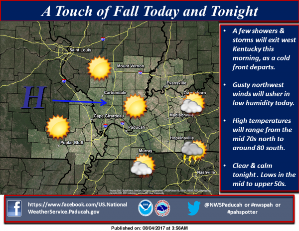
Today
Mostly sunny, with a high near 76. Northwest wind 9 to 13 mph, with gusts as high as 20 mph.
Tonight
Clear, with a low around 57. North northwest wind 5 to 7 mph becoming calm in the evening.
Saturday
Increasing clouds, with a high near 83. Calm wind becoming south around 6 mph in the afternoon.
Saturday Night
A slight chance of showers, then a chance of showers and thunderstorms after 1am. Mostly cloudy, with a low around 64. Light southeast wind. Chance of precipitation is 40%.
Sunday
Showers likely and possibly a thunderstorm. Cloudy, with a high near 79. South southeast wind 5 to 7 mph. Chance of precipitation is 70%.
Sunday Night
A 50 percent chance of showers and thunderstorms, mainly before 1am. Cloudy, with a low around 66. East southeast wind around 6 mph becoming light and variable in the evening.
Monday
Mostly cloudy, with a high near 81. North wind 3 to 6 mph.
Monday Night
Mostly cloudy, with a low around 65. North northeast wind 3 to 5 mph.
Tuesday
Mostly sunny, with a high near 83. Northeast wind 3 to 7 mph.
Tuesday Night
Partly cloudy, with a low around 63. Northeast wind 3 to 6 mph.
Wednesday
Mostly sunny, with a high near 83. North northeast wind 3 to 6 mph.
Wednesday Night
Partly cloudy, with a low around 65. North northeast wind 3 to 6 mph.
Thursday
Mostly sunny, with a high near 85. North wind 3 to 5 mph.