
Franklin Hospital board with the Lieutenant Governor
Benton, West Frankfort, Illinois News | Franklin County News
Newspaper covering Franklin County, Illinois
First of all, I apologize for being so late with this. I try to have this posted by 6:00 a.m. every morning.
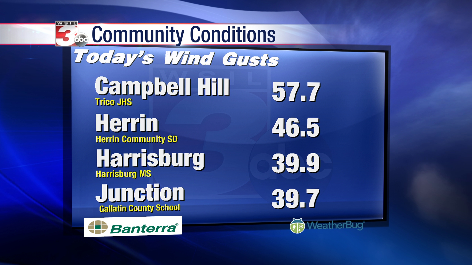
I don’t think it is any surprise to anyone, but we are under a wind advisory until 6:00 p.m. tonight. There has been spotty power outages across the county this morning as well as limbs blocking lanes of traffic on a few roadways.
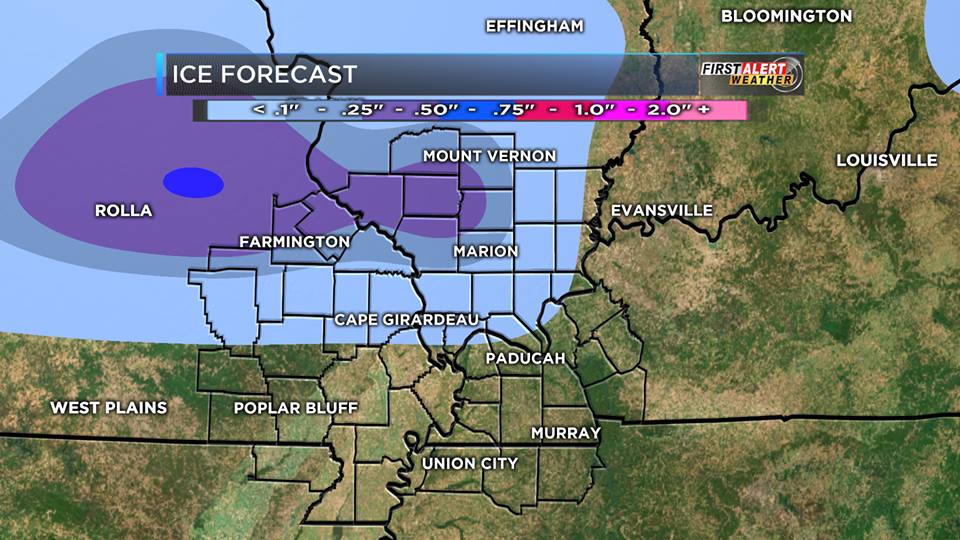
Highs today will be in the 60’s as well as the rest of the week, as freezing rain will come in the forecast for Thursday night into Friday.
Below is the latest model posted by KFVS-12 meteorologist Brian Alworth about the ice potential:
Here are the products issued by the NWS in Paducah that are in effect for Franklin County.
...VERY GUSTY WINDS WILL PERSIST TODAY...
…WIND ADVISORY REMAINS IN EFFECT UNTIL 6 PM CST THIS EVENING… * TIMING…GUSTY SOUTH WINDS WILL CONTINUE THROUGH THE AFTERNOON. * WINDS…SOUTH WINDS FROM 25 TO 35 MPH WILL GUST TO 40 TO 50 MPH AT TIMES. *
IMPACTS…POWER OUTAGES DUE TO LIMBS AND TREES FALLING ON POWER LINES CAN BE EXPECTED. THE WINDS WILL CAUSE TRAVEL DIFFICULTIES, ESPECIALLY TO HIGH PROFILE VEHICLES TRAVELING ON EAST-WEST ORIENTED ROADWAYS. ALSO, LOOSE OUTDOOR OBJECTS WILL GET BLOWN AROUND.
PRECAUTIONARY/PREPAREDNESS ACTIONS… A WIND ADVISORY IS ISSUED WHEN SUSTAINED WINDS ARE EXPECTED TO REACH 30 MPH OR GREATER FOR LONGER THAN ONE HOUR, OR WIND GUSTS ARE EXPECTED TO REACH 40 MPH FOR ANY DURATION.
THIS HAZARDOUS WEATHER OUTLOOK IS FOR PORTIONS OF SOUTHERN ILLINOIS, SOUTHWEST INDIANA, WESTERN KENTUCKY, AND SOUTHEAST MISSOURI
. .DAY ONE…TODAY AND TONIGHT WIND GUSTS COULD REACH 40 TO 45 MPH FROM THIS MORNING THROUGH LATE THIS AFTERNOON. .
DAYS TWO THROUGH SEVEN…WEDNESDAY THROUGH MONDAY THUNDERSTORMS WILL BE POSSIBLE FROM WEDNESDAY THROUGH THURSDAY. STRONG STORMS CANNOT BE RULED OUT THURSDAY.
FREEZING RAIN AND A GLAZE OF ICE ARE POSSIBLE ACROSS PORTIONS OF SOUTHEAST MISSOURI…SOUTHERN ILLINOIS AND SOUTHWEST INDIANA FROM LATE THURSDAY NIGHT THROUGH EARLY FRIDAY EVENING.
HEAVY RAINFALL AMOUNTS ARE FORECAST…THOUGH THE EVENT WILL BE SPREAD OUT OVER SEVERAL DAYS. THIS WILL LIKELY RESULT IN STANDING WATER IN LOW LYING AND POOR DRAINAGE AREAS…ALONG WITH RISES IN SMALL CREEKS AND STREAMS.
For updates about the unsettled weather conditions we are facing check franklincounty-news.com for continuous updates and possible cancellations throughout the week.
Here is a link to the seven day forecast for Franklin County.
http://forecast.weather.gov/MapClick.php?map.x=176&map.y=89&site=pah&zmx=1&zmy=1#.WHT3xdQrJxA
 The furthest south railroad crossing on South Main Street (Route 37) in Benton is closed for repairs. The road will open back up around 7:00 p.m. on Tuesday.
The railroad crossing on East Main street (Route 149) will be closed on Wednesday morning around 7 a.m. on and reopen around 7 pm on Thursday for repairs also.
This is weather pending. If rescheduled, franklincounty-news.com will pass along an alternate date.
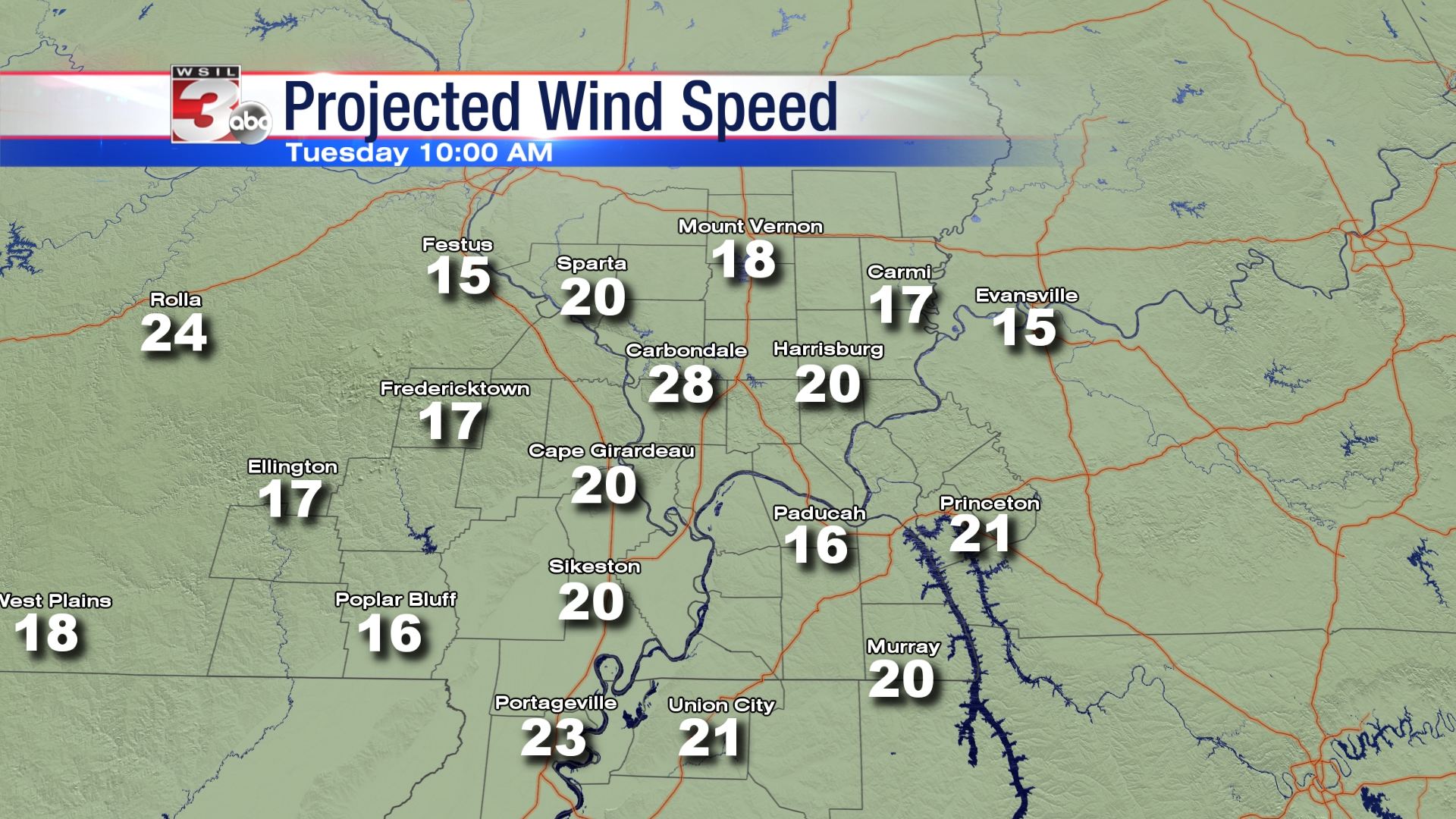
Image from WSIL TV Meteorologist Ashley Smith
Good Morning!!!! It is going to be a windy Monday. It will be Sunny with a high of 39 degrees today. There is a 40% chance of rain tonight with rising temperatures throughout the night.
Highs will be in the 50’s to around 60 Tuesday through Thursday until a cold front goes through the region on Friday and a wintry mix is forecasted. Temperatures will yo-yo throughout the weekend.
Here is the Hazardous Weather Outlook from the National Weather Service in Paducah KY:
SOUTH WINDS WILL START PICKING UP THIS AFTERNOON AND CONTINUE OVERNIGHT. SOME AREAS MAY SEE WINDS INCREASE TO AS HIGH AS 20 TO 25 MPH SUSTAINED…WITH GUSTS INTO THE 30 TO 35 MPH RANGE POSSIBLE. THIS WILL POSE A HAZARD TO AREA TRAVEL…ESPECIALLY TO HIGH PROFILE VEHICLES. SECURE ANY LOOSE OUTDOOR ITEMS THAT MAY BE STREWN ABOUT BY THE WIND. .DAYS TWO THROUGH SEVEN…TUESDAY THROUGH SUNDAY THUNDERSTORMS ENTER THE FORECAST TUESDAY NIGHT ACROSS MAINLY WESTERN KENTUCKY, AND AREA WIDE WEDNESDAY. THUNDERSTORMS RETURN AGAIN TO THE FORECAST FOR SOME LOCATIONS THURSDAY. LOCALLY HEAVY RAIN WILL BE THE PRIMARY THUNDERSTORM RELATED HAZARD. A WINTRY MIX OF PRECIPITATION IS FORECAST FRIDAY AND FRIDAY NIGHT FOR THE NORTHWESTERN TIER OF COUNTIES. THE SAME EVENT IS POSSIBLE SATURDAY NIGHT ALSO, BUT TO A LESSER DEGREE. HEAVY RAINFALL RATES ARE POSSIBLE THURSDAY NIGHT THROUGH SATURDAY. PONDING OF WATER ON ROADWAYS AND INUNDATION OF LOW LANDS AND FLOOD PRONE AREAS IS EXPECTED.
http://forecast.weather.gov/MapClick.php?map.x=176&map.y=89&site=pah&zmx=1&zmy=1#.WHN1oNQrJxA
 After a frigid weekend, temperatures are going to warm up into the 50’s next week. There is a chance of wintry precipitation in the long range forecast.
Here is the latest Hazardous Weather Outlook by the National Weather Service.
.DAY ONE…TODAY AND TONIGHT SINGLE DIGIT WIND CHILLS ARE EXPECTED EARLY THIS MORNING.
.DAYS TWO THROUGH SEVEN…MONDAY THROUGH SATURDAY RAIN RETURNS TO THE FORECAST TUESDAY AND LASTS THROUGH MUCH OF THE REST OF THE WEEK. LOCALLY HEAVY RAINFALL IS POSSIBLE. THUNDER RETURNS TO THE FORECAST TUESDAY NIGHT AND THURSDAY…MOSTLY ALONG AND SOUTH AND EAST OF THE OHIO RIVER. ANY THUNDERSTORMS MAY ENHANCE LOCALLY HEAVY RAINS. LOCALLY HEAVY RAINFALL IS POSSIBLE DURING THE WEDNESDAY NIGHT THROUGH FRIDAY TIME FRAME.
RAIN MAY CHANGE TO A WINTRY MIX LATE FRIDAY NIGHT OR EARLY SATURDAY MORNING BUT IT IS TOO EARLY TO TELL WITH CERTAINTY OR SPECIFICITY.
http://forecast.weather.gov/MapClick.php?map.x=176&map.y=89&site=pah&zmx=1&zmy=1#.WHJiCdQrJxA
Above is a link to the seven day forecast for Franklin County.
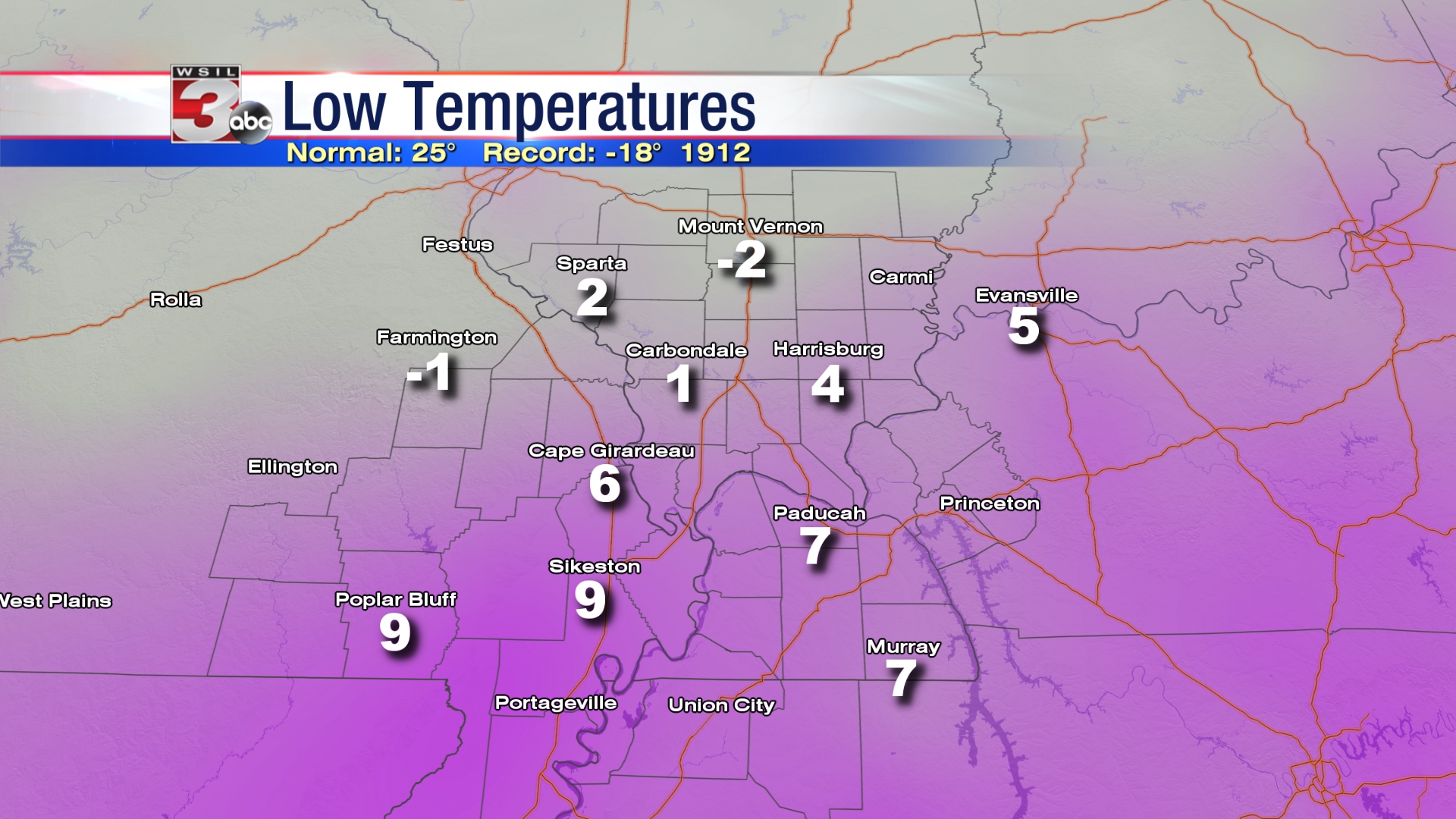
Good morning!!!! As you can see from the graphic above by Channel 3 meterologist Rachel Duensing, we were off to a very bitter start around the region. The high today will be in the low 20’s, with the low tonight in the single digits.
There will be a gradual warming trend, but next week will be very wet with several chances of rain.
Here is a link to the seven day forecast for Franklin County by the National Weather Service.
http://forecast.weather.gov/MapClick.php?map.x=176&map.y=89&site=pah&zmx=1&zmy=1#.WHEMmNQrJxA
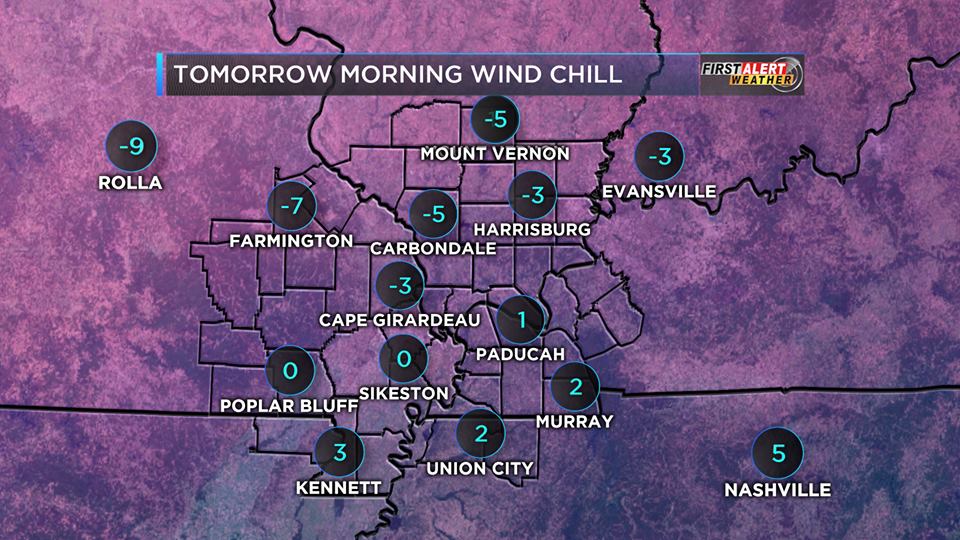
Forecasted wind chills for this morning.
Flurries are falling here in West Frankfort as I write this. We have a couple of cold days in front of us . Highs today and tomorrow will be around 20 degrees, with lows around 10. A warming trend will take place early next week, with chances of rain back in the forecast.
Here is a link to the seven day forecast for Franklin County.
http://forecast.weather.gov/MapClick.php?map.x=176&map.y=89&site=pah&zmx=1&zmy=1#.WG-HpdQrJxA
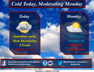
It is going to be Sunny and windy today with a high of 31 degrees. The low is going to be 19 tonight with snow moving in during the overnight hours.
Click the following link for the seven day forecast for Franklin County.
http://forecast.weather.gov/MapClick.php?map.x=176&map.y=89&site=pah&zmx=1&zmy=1#.WG0QudQrJxA
Here is a special weather statement issued by the National Weather Service in Paducah KY for Franklin and surrounding counties :
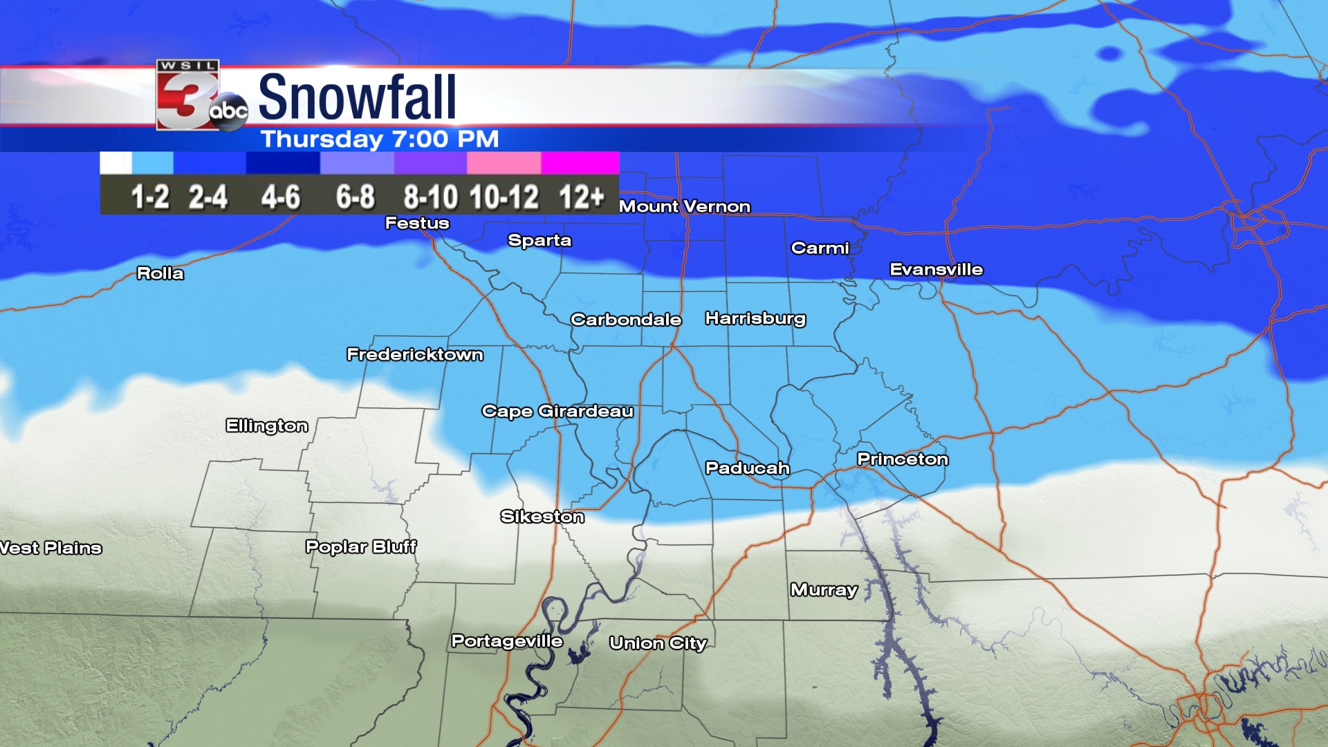
…FIRST ACCUMULATING SNOW OF THE SEASON POSSIBLE THURSDAY…
With Arctic air already in place across the region, an upper-level storm system will produce a swath of light snow, as it swings through our region Thursday.
The initial band of light snow may reach the Interstate 64 corridor of southern Illinois just prior to daybreak Thursday, but the bulk of the accumulating snowfall is expected in the morning hours. 1 to 2 inches of snow is possible across the Interstate 64 corridor of southern Illinois and southwest Indiana.
The snow is expected to taper off quickly from west to east Thursday afternoon. Farther south across the region, a half inch or less is expected, and much of the area may only see a few periods of flurries.
At this time, considerable uncertainty exists with this storm system. On the high end, the potential exists for light accumulations across the entire area, with narrow bands of enhanced snowfall. On the low end, a very minor adjustment could result in nothing but flurries across the area.
With the cold air in place, any accumulations would likely create travel difficulties. Please stay tuned for the latest forecasts and statements on this potential winter storm system from the National Weather Service in Paducah, Kentucky.
Follow franklincounty-news.com for advisory updates and possible cancellations throughout this possible winter weather event.