Gradual clearing today….tomorrow is going to be beautiful

weather 124

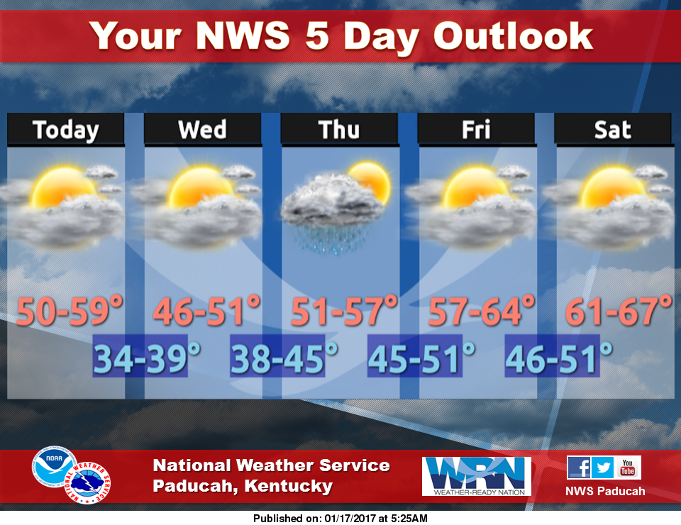
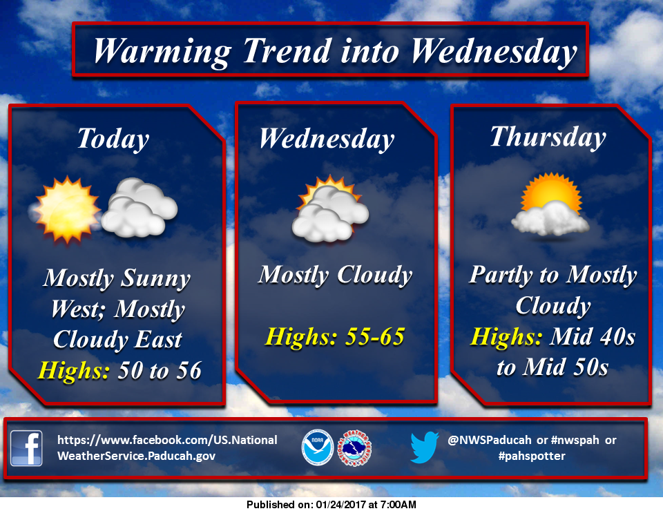
Today we will have gradual clearing and maybe some peaks of the sun.  The high today will be in the mid 50’s.  The low tonight will be in the mid 40’s.  It will be sunny tomorrow with the high around 60, and the lows in the 40’s Wednesday night.

There will be a cooling trend for the rest of the week with highs in the upper 30’s and lows in the mid 20’s.

There is a chance of rain or snow in the forecast for Sunday.

Another rainy Sunday ahead

It seems like we have another rainy Sunday ahead of us.  The high today will be around 60 degrees with the low in the upper 40’s.

We will have a pleasant Monday through Wednesday with high around 50 degrees with the lows in the 30’s.

It will be cooler the rest of the week with highs in the upper 30’s with lows in the mid twenties.

Over night there has been massive tornado destruction in the Southeastern coastal states of the US.  The storm prediction center rarely issues a high risk for severe weather.  This is displayed below in the following graphic from KFVS-12

channel 12 graphic severe weather SE us


Dr Greg Forbes of The Weather Channel has several ares in the Southeastern part of the United States with a TORCON of nine, which means there is a 90% chance of a tornado within a 50 mile area.  Here is the areas in the following graphic.

Torcon 122

Remember this region in your prayers during a day that shapes up to be very volatile.


Unseasonably mild today and tomorrow…..rain sunday

Even though cloudy today, highs will be in the upper 50’s today.  Highs will be in the 60’s tomorrow with a 30% chance of showers and thunderstorms in the afternoon into the overnight hours.

Weather story 12017

There is a 50% chance of rain on Sunday and Sunday night.  There are no advisories or a hazardous weather outlook today for Franklin County.

Here is a link to the seven day forecatst:

http://forecast.weather.gov/MapClick.php?map.x=176&map.y=89&site=pah&zmx=1&zmy=1#.WIImu9QrJxA

Benton Police make recent arrests

Here is the latest police blotter from the Benton police department:Benton Police

On January 16th, 2017 Benton Police arrested Craig Parrish, age 33, of Benton on an active Franklin County warrant for failure to appear on possession of methamphetamine.
Parrish was taken to Franklin County Jail for processing.
On January 16th, 2017 Benton Police arrested Dennis C. Summers, age 22, of Benton on an active Franklin County warrant for failure to appear on consumption of liquor by a minor.
Officers also located methamphetamine and drug paraphernalia on Summers at the time of the arrest.
Summer was taken to Franklin County Jail for processing.

Stand for Life – Sign the Petition

pro lifeNote: I don’t know what my title is but I am unapoligetically pro life. I whoeheartedly believe life begins at conception. If you are pro-choice, my intentions are not to shove this down your throat. There is a petition on Dave Severin’s website to stand for life if you are of that persuasion. The bill before the Illinois Legislature is explained sd.

Rain retruns for tomorrow/Saturday night and in to Sunday

Good morning!

Here is your mid day forecast.  Today it will be cloudy with a high in the upper 40’s.  Rain chances return overnight, into tomorrow.  We are supposed to have a beautiful Friday and Saturday, with highs in the 60’s., before rain returns on Saturday night into Sunday.

Forecast jan18

Here is the Hazardous weather outlook for the region:

THIS HAZARDOUS WEATHER OUTLOOK IS FOR PORTIONS OF SOUTHERN ILLINOIS, SOUTHWEST INDIANA, WESTERN KENTUCKY, AND SOUTHEAST MISSOURI.

.DAY ONE…TODAY AND TONIGHT A FEW RUMBLES OF THUNDER ARE POSSIBLE AFTER MIDNIGHT TONIGHT ACROSS SOUTHEAST MISSOURI, SOUTHERN ILLINOIS, AND WESTERN KENTUCKY. LIGHTNING WILL BE THE MAIN IMPACT.

.DAYS TWO THROUGH SEVEN…THURSDAY THROUGH TUESDAY THERE IS A CHANCE FOR THUNDERSTORMS ACROSS MUCH OF THE AREA THURSDAY AND THURSDAY EVENING. LIGHTNING AND LOCALLY HEAVY RAINFALL WILL BE THE PRIMARY IMPACTS.

THE RAINFALL MAY BE STEADY AND PERSISTENT ENOUGH TO RESULT IN STANDING WATER IN SPOTS. THIS IS MOST LIKELY NEAR AND SOUTH OF THE OHIO RIVER WHERE THE HEAVIEST RAIN FELL WITH THE LAST EVENT AND IS FORECAST DURING THIS EVENT.

Here is a link to the full seven day forecast for Franklin County


http://forecast.weather.gov/MapClick.php?x=185&y=93&site=pah&zmx=&zmy=&map_x=185&map_y=93#.WH-QZdQrJxB

Suspicious fire destroys vacant West Frankfort home

WSIL-TV photo

WSIL-TV photo

WEST FRANKFORT- (Link to WSIL-TV website for full story) Investigators are calling an early-morning house fire in West Frankfort suspicious. A West Frankfort police officer said he spotted the fire around 3:15 a.m. in the 200 block of North Anna Street. Officials said the house was vacant with “For Sale” signs outside. The home is considered a total loss. One firefighter suffered a pulled hamstring while battling the blaze…….

Authorities investigating threat to Sesser-Valier School

WSIL Image

WSIL Image

FRANKLIN CO. –(Click on the link to WSIL-TV 3’s website for the full sotry). Authorities are investigating after a threat to a Sesser school Tuesday night. District Superintendent Jason Henry says that at around 5:20 p.m., Franklin County Central Dispatch received a call about a “terrorist” event at Sesser-Valier School. School officials and police immediately evacuated the main school building. Sesser Police, along with Illinois Secretary of State Police and the FBI, conducted a canine sweep of the school and investigated the origins of the threat. At around 7:30 p.m., an out-of-state resident, whose name is not being released at this time, was identified as a person of interest in this investigation. Authorities believe this person may be the same person who committed a similar offense against the Sesser-Valier school community on February 21, 2016. …..

Redbirds easily handle the Bearcats

by Steve Dunford

WEST FRANKFORT – Austin Glodich Dominated both ends of the floor in the 12 minutes he played with thirteen points and seven rebounds as West Frankfort defeated Christopher 59-35 in the opening round of pool play at the West Frankfort Midwinter Classic.midwinterclassic

Glodich rolled an ankle with two minutes and some change on the clock in the first half.  He will be ready to play in Wednesday night’s game against Carterville.

Christopher was short handed to begin with without the services of Bradley Young and Gabe Schimpf, who will return for tonight’s game against Eldorado.  Coach Eric Stallman played a 2-3 zone all night against the Redbrids which the Bearcats play man to man 99% of the time.

It might have been storming outside, but the perfect storm happened on the floor for Christopher in the first half.  Jared Curry sit most of the second quarter with two fouls.  Different ones for the Redbirds guarded Kaeleb Pedigo, and he was held scoreless.  Both teams went to the locker rooms with the score 33-18.

There were a couple back breaking threes by Noah Allen in the third quarter that sealed the deal for the Redbirds.  Coach Kevin Toney subbed freely most of the second half.

Along with Glodich’s 13 on the night Allen had 11 on the night to pace WF.  Gabriel Motsinger, a freshman making his first varsity start, led the Bearcats with 10 on the night.

The Redbirds improve to (7-8) on the season and (1-0) in their pool.  They play Carterville tomorrow night at 8:30.  The Bearcats fall to (11-5) on the season and (0-1) in pool play.  They have the unenvyous task of taking on the Eldorado Eagles, the No #6 team in the state in class 2A in the latest AP rankings.

BOX SCORE:

WEST FRANKFORT   (59)  Glodich 5 0 3-6 13; Allen 1 3 0-0 11; Hammers 3 0 0-1 6; D. Russell 1 1 0-0 5; Sturgill 2 0 0-0 4; Thrash 2 0 0-0 4; Clinton 2 0 0-0 4; Levanti 0 1 0-0 3; Wolfe 0 1 0-0 3; Riddle 0 1 0-0 3; Johnson 0 1 0-0 3; Russell 0 0 0-0 0; Powell 0 0 0-0 0; House 0 0 0-0 0; Clark 0 0 0-0 0; Croslin 0 0 0-0 0

CHRISTOPHER (35)  Motsinger 3 1 1-2 10; Pedigo 1 2 0-0 8; Curry 4 0 0-1 8; Snell 0 1 2-2 4; Sanders 0 1 1-2 3; Pratt 0 1 0-0 2; Saeger 0 0 0-0 0; Dorris 0 0 0-0 0; Hawkins 0 0 0-0 0; Dunford 0 0 0-0 0; Flowers 0 0 0-0 0

SCORE BY QUARTERS 

WEST FRANKFORT   15    18    14    12  –  59  

CHRISTOPHER              7    11      8      9  –  35


No rain today and tomrorrow

For this wet January that is a welcome sight.  Here is the five day forecast for the region.  There are no advisories to talk about today.  I hope you have a great Tuesday.

forecast jan 1717

Benton, West Frankfort, Illinois News | Franklin County News