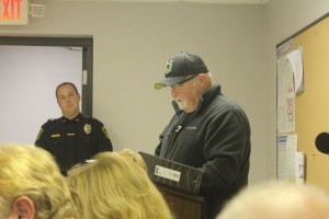
Rocky Morris of the Benton Airport Board addresses the Benton City Council. (William McPerson – Benton Gazette)
Benton, West Frankfort, Illinois News | Franklin County News
Newspaper covering Franklin County, Illinois
Rocky Morris of the Benton Airport Board addresses the Benton City Council. (William McPerson – Benton Gazette)
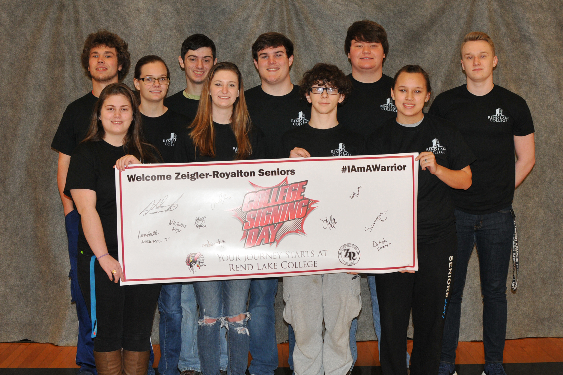
Pictured is, FRONT ROW, FROM LEFT, Dakota Emery, Summer King, Andrew Morris, and Lyla Miller; BACK ROW, Jakob Baxter, Haley Edwards, Nicholas Fry, Austin Bolinger, Kendall Cochran, and Nolan Domineck. Not pictured is Sydney Noto and Amber Reece.
(ReAnne Palmer / RLC Public Information)
ZEIGLER– More than a third of Zeigler-Royalton High School’s senior class will be making their way to Rend Lake College next year after enrolling in summer and fall classes during College Signing Day. Today, RLC Advisors met with the students to get them prepared for the next academic year.
RLC Academic Advisors will visit Mt. Vernon Township, Pinckneyville Community, and Webber Township high schools next month to register interested seniors for classes at RLC. Advisors will visit all 13 in-district high schools in the coming weeks.
Registration for Summer 2017 is going on now for all students with classes starting the week of June 5-9. Fall 2017 registration for sophomores begins Monday, April 3 by appointment. For incoming students, Fall 2017 enrollment appointments begin Monday, April 17. The Fall semester begins the week of August 14-18.
According to the U. S. Department of Education, college graduates typically earn more and are less likely to face unemployment than those with a high school diploma. Over the course of a lifetime, the average worker with a postsecondary degree will earn approximately $1 million more than a worker without a postsecondary education. In fact, by 2020, an estimated two-thirds of job openings will require postsecondary education or training.
RLC is a comprehensive community college located in Ina in Southern Illinois. Rend Lake College offers more than 100 associate degree and occupational certificate programs, preparing students for transfer to a four-year university or direct entry into the workforce. In addition, RLC offers personal interest classes, continuing education, business & industry training, computer workshops and much more. To learn more about RLC, visit www.rlc.edu/journey.
National Weather Service Paducah KY image.
This afternoon it could be a very volatile situation weather wise. The line of storms that was supposed to be on top of us that caused some severe weather a few hundred miles to our west fizzled out. This will cause more fuel for the atmosphere.
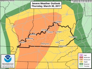
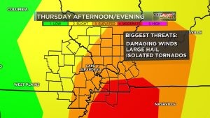
The Storm Prediction Center in Norman OK, has all of Southern Illinois an an Enhanced (level three of five) risk of severe weather.
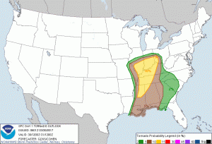
Graphic from the Storm Prediction Center in Norman, OK showing the tornado threat
Instead of a line, super cell development will be likely, instead of a line. Unfortuately, the chance of tornadoes will be higher. Dr. Greg Forbes has the TORCON level at a four still. The storm prediction center is predicting a 10 percent chance of a tornado in a 25 mile radius of us here in Franklin County.
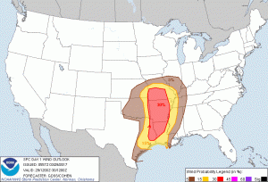
The large hail and damaging thunderstorm wind threat is 30% in a 25 mile radius, for this afternoon. All these percentages might seem small, but being under an enhanced risk is rare. It is anticipated by several in the weather community the risk can be upgraded to a moderate later this morning.
Here is the Hazardous Weather Outlook issued by the National Weather Service in Paducah KY:
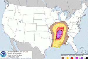
Here is the damaging thunderstorm wind probability map by SPC. The map for large hail is very similar.
.DAY ONE…Today and Tonight There is a risk of severe thunderstorms today. The storms will be capable of large hail, damaging winds and possibly tornadoes. The area with the highest probability for severe storms will be east of the Mississippi River. The time frame of concern is from midday through late afternoon.
.DAYS TWO THROUGH SEVEN…Friday through Wednesday There is a chance of thunderstorms Sunday afternoon through Monday morning, and then again Wednesday. The probability for widespread hazardous weather is low.
Looking at several weather models, as well as the opinion of the meteorologists in all three TV stations in this market, is the timing will be from Noon-3:00 P.M. for Franklin County.
The models are showing a good possibility of super-cell thunderstorm development. There is the possibility these storms can develop and intensify rather quickly. They are more likely to have rotation.
This will not be your typical squall line event. There will be a line that will form when the storms are east of here. Because of this, advance warning could be less.
It would be a good idea for schools and businesses to go over their tornado safety plan. I am not saying that we are going to have an event like we had a few weeks ago. However, there is a high likelihood of a tornado warning being issued. It would also be wise to take precautions in case there is a power outage.
There will be frequent updates throughout the day. Keep abreast of this situation from your favorite media source. As of this time, I will be monitoring the radar all day.
I will post when a watch is issued on the website. When warnings start rolling in, time might not allow me to post things on the website. I will post them on the Facebook page.

Still shot to the introduction to the Wild Bill documentary. (Ethan Talley photo)
Laura Wibbemeyer-KFVS TV
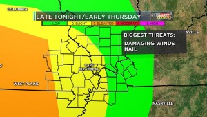
There will be two rounds of severe weather that will be hitting Franklin County and the rest of Southern Illinois. One will be late tonight. The other one will be this afternoon and evening.
This is for the chance of wind damage in Southern Illinois tonight. This means there is a 5% chance of someone experiencing damaging thunderstorm winds in a 25 mile radius. The hail threat is similar. (SPC image)
The first round will be late tonight into the early morning hours. At this time the tornado threat will be minimal. Large Hail and damaging winds will be the greatest threat. Franklin County is in a marginal risk (level 1 of 5) for severe weather in this event.
Tomorrow is where things will get interesting. The tornado threat will be higher. Here in Franklin County we are under a marginal risk (level 3 of 5) for severe weather tomorrow.
Dr. Greg Forbes, The Weather Channel
For Southern Illinos, Dr. Greg Forbes of the weather channel has the TORCON level at four. This means there is a 40% change that there will be a tornadic event 50 miles from your location.
Here is the hazardous weather outlook issued by the National Weather Service in Paducah, KY.
.DAY ONE…Today and Tonight Isolated strong to severe thunderstorms will be possible late tonight, mainly after midnight across southeast Missouri, far western Kentucky and southern Illinois. Locally heavy rain is also possible. .
Laura Wibbemeyer-KFVS TV
DAYS TWO THROUGH SEVEN…Thursday through Tuesday There is a good chance of severe thunderstorm activity Thursday across most of the area, from midday through late afternoon. The area of greatest concern is western Kentucky at this time. Large hail, damaging winds and a few tornadoes will be possible. Locally heavy rainfall is also possible. There is a chance of thunderstorms next Monday.
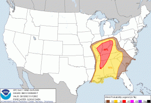
Franklin County and most of Southern Illinois have a 30 percent chance of experiencing some type of severe weather event in a 25 mile radius. SPC image
I will do my best to keep an eye on the radar through the severe weather event overnight and tomorrow afternoon. Any weather briefing videos or Facebook Live posts from local meteorologists will be posted on the franklincounty-news.com Facebook page. -sd
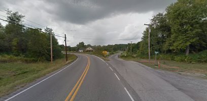
View of St. Route 149 going east to west. Growing up in Thompsonville, I more than realize the danger of this intersection. I am glad some reconstruction will be done to it. -sd (Google Maps image)
