Orient man arrested on sex offender charge

Press Release from the Franklin County Sheriff’s office

Alan Marsh

Alan Marsh

On April 28th at 3:40 pm, Deputies arrested Alan T. Marsh, 56 of Orient, for violations of the Sex Offender Registration Act.  Marsh is a registered sexual predator.

The arrest was made in Benton.  Marsh is being held in the Franklin County Jail in lew of $15,000 bond.

Herrin man arrested on sexual abuse of minor charges

Press Release from the Franklin County Sheriff’s office 

Joseph Ryker

Joseph Ryker

On April 28, 2017 at 12:00 p.m. Franklin County Sheriff’s Investigators, assisted by Deputy United States Marshalls arrested Joseph A. Ryker Age 26 of Herrin. The arrest was made on the campus of Rend Lake Community College. The arrest was made on a warrant charging six counts of aggravated criminal sexual abuse (class 2 felonies), one count of indecent solicitation of a child (class 3 felony) and one count of grooming (class 4 felony). The victim is a 15 year old high school student. Ryker is being held in the Franklin County Jail in lieu of $250,000.00 bond. The investigation is continuing and more charges and arrests are possible.

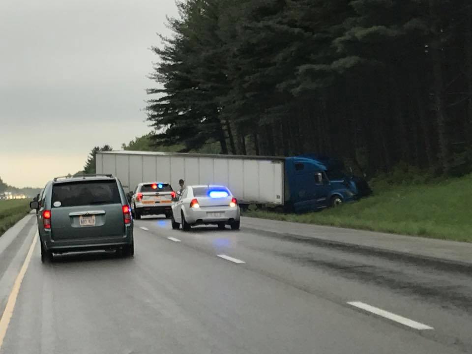
Another I 57 wreck

Picture provided by Amanda Smith to KFVS C-News.

Picture provided by Amanda Smith to KFVS C-News.

According to several social media reports, media, and the Illinois State Police there has been a semi accident on I 57 southbound, between the 73 and 74 mile markers.  This is just north of the Benton exit.  The accident occurred around 3 pm.

Traffic was backed up in both lanes, and now one lane is open.  Seek alternate routes.

sd

Talleys in Thompsonville tomorrow night

by Steve Dunford 

CORRECTION- THE START TIME IS AT 6:00p.m.  I POSTED SEVEN-  I APOLOGIZE FORE THE MISTAKE… 

talleys promo pic

One of my favorite Southern Gospel Groups, the Talleys will be in concert tomorrow night (Saturday April, 29th) at the Thompsonville First Baptist Church.  The church is located one block east of the school on Route 34.  The service starts at 6:00 p.m.  Admission is free.  A love offering will be taken.

I have seen them in concert several times.  It is a group consisting of the father Roger, the mother Debra, and the daughter Lauren, who has one of the best alto voices in America, in my opinion.  My personal favorite songs the perform is Searching and The Healer

The church has been getting some big name national acts here lately, recently The Kingsmen performed there.

Here is the groups bio from their website:

The Talleys are one of Christian music’s most beloved and respected families. Their commitment to excellence and creativity in music have been their trademark since their illustrious career began, and their clear communication of the gospel is a defining characteristic of a Talley concert.

The Talleys began in 1984 and enjoyed many years of success, including a Dove Award and numerous Singing News Fan Awards. Following a three-year hiatus, the Talleys began performing together in 1996 with the current lineup of Roger, wife Debra and daughter Lauren, and today the Talleys remain a mainstay of Christian music.

The Talleys have enjoyed eleven number one songs, and have received numerous Singing News Fan Awards and Dove Award nominations. They are frequently recognized for their appearances on the Gaither Homecoming video series and concert tour, as well as In Touch with Dr. Charles Stanley and John Hagee Ministries. They have appeared on RFD-TV’s “The Music City Show,” and have toured overseas to Norway, Northern Ireland, Italy and South Africa. The Talleys consistently take their music with a message to hundreds of concert and church audiences of all sizes across America each year.

“It’s message music. When people hear our songs, we want them to clearly understand the gospel in the lyrics, and know that God really can make a difference in their lives,” says Lauren. “Whether we’re in front of thousands, or in the local church on a Sunday, that message is the same.”

The Talleys are a self-described “normal family,” but whether they grace a concert hall, a church platform or enjoy a ball game on TV at home, they are dedicated to God and family.


Number 1 Songs (Singing News Chart)

Searchin’   (3 consecutive months)
The Healer   (2 consecutive months)
Jesus Saves   (2 consecutive months)
The Broken Ones
His Life For Mine
The Answer Is Chist
I Love The Lord / Total Praise
The Debt
Life Goes On
That’s Enough Up Above

Pastor John Robinson and the rest of the body of believers at Thompsonville First Baptist Church welcome you.


Update on the weather situation

by Steve Dunford 

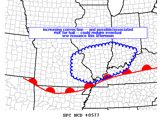
mcd0577First of all everything from my previous post applies.  The Storm Prediction center currently has All of Southern Illinois under a meso (which means Mesoscale Discussion).  This is an area the SPC monitors for watch issuance.  (See graphic above)
There is a strong possibility a watch will be issued over the next two hours for Southern Illinois.  In my opinion, most likely it will be a Severe Thunderstorm Watch. However, I would not be a bit surprised if a Tornado Watch would be issued.

There are a couple cells that is firing in Southeast Missouri.  There is one in that has has prompted a Severe Thunderstorm Warning.  If it stays together, it has the potential to go through parts of Randolph, Perry, and Jefferson Counties.

I am keeping an eye on a cell that is in Cape county at the time that has the potential to move into Franklin County that could affect some afternoon sporting events.  Grant Dade put the track on it, and it has the potential to reach Carbondale at 2:30.

I am watching what this does as it crosses the river.  During a severe weather event, please check the Facebook page and your favorite media source.  Things develop too quickly to post on the website, but I  will make the effort.


Keep your eye to the sky through the weekend

by Steve Dunford 

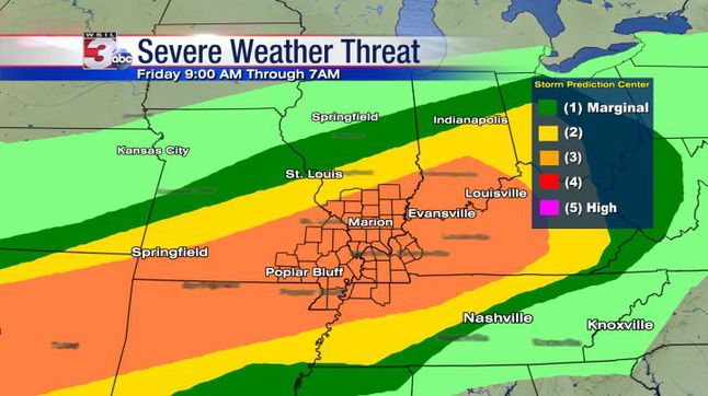
SPC places Southern Illinois at level 3 for Severe threat. We believe focus time is later day and overnight. Look for live stream as storms approach. (WSIL TV Chief Meteorologist Jim Rasor)

SPC places Southern Illinois at level 3 for Severe threat. We believe focus time is later day and overnight. Look for live stream as storms approach. (WSIL TV Chief Meteorologist Jim Rasor)  A personal note from me.  We have three very good weather teams in this market.  You will not go wrong with channels three, six or twelve.  Personally during a severe weather threat, I always monitor channel 12 first, then when it approaches Southern Illinois, I flip between the two. )

Over the next seventy two hours we will have a risk for severe weather over the weekend.  Today is an enhanced risk and Saturday and Sunday is a slight risk.

The main reason we are under an enhanced risk today is the risk for large hail.  Damaging thunderstorm winds and isolated tornadoes will be a risk throughout the weekend.

This is a storm system that will be a challenge to forecasters.  We have an advancing warm front that will become stationary across the region.  It will convert into a cold front and pass the region sometime on Sunday.

This will wobble back and forth.  Right now with cloud cover and around 60 degrees I am wondering if the front has gone stationary right now and we are in the cold sector.  As long as the cloud cover remains, there will be a cap among the atmosphere.  Looking at the latest radar, I would say the front is in the route 50 corridor now.

For high school sporting events  as long as the cloud cover remains, we should get the games in with some passing sprinkles.  If the sun pops out, it might be another Athletic Director’s nightmare as pop up thunderstorms could form.

This is one of those forecasts that will be updated frequently.  That is why it is important not to have fear but be aware over the weekend.

There is a site out there on social media that has a doomsday scenario painted for a few Southern Illinois counties, including Franklin for the overnight hours.  This is over-sensationalized, and borderline being fake.  There is a threat for the possibility of severe weather, and make sure you have your NOAA weather radios on tonight, be aware, but don’t be alarmed until you have to.

We are going to get a lot of rain over the weekend, how much is varying by the models.  There are some that is as few as three inches, some as high as seven.

At this time the pool at Rend Lake is 407.1 ft, that is going over the spillway swiftly At 410′ is when concern should start, as water will be flowing over the entire spillway.

The Big Muddy at Plumfield is at 13.2 feet now.  It will not reach flood stage until sometime late Saturday or Sunday, which is 20 feet.  It is forecasted to crest late Monday afternoon at 22.7 feet.

Below is the information on the  Flash Flood Watch and hazardous weather outlook from the National Weather Service from Paducah, KY.

…FLASH FLOOD WATCH REMAINS IN EFFECT FROM THIS EVENING THROUGH LATE SUNDAY NIGHT… The Flash Flood Watch continues for * Portions of southern Illinois, western Kentucky, and southeast Missouri, including the following areas, in southern Illinois, Alexander, Edwards, Franklin, Gallatin, Hamilton, Hardin, Jackson, Jefferson, Johnson, Massac, Perry IL, Pope, Pulaski, Saline, Union, Wabash, Wayne IL, White, and Williamson. In western Kentucky, Ballard, Carlisle, Fulton, Hickman, and McCracken. In southeast Missouri, Bollinger, Butler, Cape Girardeau, Carter, Mississippi, New Madrid, Perry MO, Ripley, Scott, Stoddard, and Wayne MO. * From this evening through late Sunday night *

The watch is generally in effect for locations along and west of a line extending from near Fulton, Kentucky to Mount Carmel, Illinois, including all of southeast Missouri and southern Illinois. Much of this region already received 1.5 to 3 inches of rainfall Wednesday and Wednesday night. Numerous thunderstorms with very heavy rain are expected to develop later this afternoon and continue tonight. Some areas of western Kentucky and the southern tip of Illinois may see a break in the precipitation Saturday into Saturday night, but will then see more thunderstorms with very heavy rainfall move in from the west late Saturday night and through the day Sunday. From 3 to 6 inches of rain could fall in the watch area by the time the entire event is finished Sunday night. Locally higher amounts are also possible where numerous thunderstorms repeat. * In addition to the possibility of flash flooding of some roadways and streams, the heavy rainfall is expected to cause rises on many of the area rivers, particularly the smaller rivers in southeast Missouri, such as the Saint Francis, Black, and Current

. PRECAUTIONARY/PREPAREDNESS ACTIONS… A Flash Flood Watch means that conditions may develop that lead to flash flooding. Flash flooding is a very dangerous situation. You should monitor later forecasts and be prepared to take action should Flash Flood Warnings be issued.

Flood Warning National Weather Service Paducah Kentucky 948 AM CDT Fri Apr 28 2017 ...

The National Weather Service in Paducah, Kentucky has issued a flood warning for a portion of the Big Muddy River affecting areas in southwest Illinois… Near Plumfield affecting Franklin and Williamson Counties. .Due to heavy rainfall across the river basin over the past couple of days, and anticipated rainfall expected over the weekend, water levels are expected to rise above flood stage along the Big Muddy River near Plumfield later this weekend and crest early next week. PRECAUTIONARY/PREPAREDNESS ACTIONS… SAFETY MESSAGE… Never drive cars…trucks or sport utility vehicles through flooded areas. The water may be too deep to allow safe passage. Never allow children to play in or near flood waters. Stay tuned to NOAA Weather Radio or your local media for further statements and possible updated forecasts.

This Hazardous Weather Outlook is for portions of southern Illinois, southwest Indiana, western Kentucky, and southeast Missouri. .

DAY ONE…Today and Tonight Scattered severe thunderstorms will be possible this afternoon and tonight over the entire quad state region. Very large hail be possible in the stronger storms, along with damaging wind gusts. Isolated tornadoes will also be possible. In addition, a Flash Flood Watch is in effect for all of southern Illinois, southeast Missouri and the western tip of Kentucky this evening through Sunday evening. From 3 to 6 inches of rainfall may occur over the course of the weekend. East of the watch, additional rains of 1 to 3 inches may occur. Please refer to the watch product for more details. .

DAYS TWO THROUGH SEVEN…Saturday through Thursday A Flash Flood Watch will remain in effect through Sunday evening for multiple rounds of thunderstorms containing very heavy rain. Please refer to the watch product for more details. In addition, scattered severe thunderstorms will continue to be possible periodically through much of the weekend. Large hail and damaging wind gusts are expected to be the main hazards. However, isolated tornadoes cannot be ruled out. There is a chance of thunderstorms over the southern third of the Outlook area on Wednesday. Any storms that develop are not expected to be severe at this time.


Thompsonville destroyed by an EF-3 tornado, April 27, 1971

by Steve Dunford 


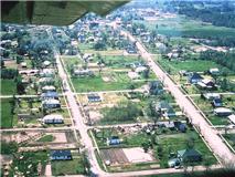
Arial view of the village after the tornado (Photo provided by Kathy Wiegand)

Arial view of the village after the tornado (Photo provided by Kathy Wiegand)

Yesterday morning I started writing this.  This is something that I did not have the intention of writing.

This is recalling some of the stories that I have heard over the years of April 27, 1971, the day before my first birthday.

It was an unusually warm April day.  Highs were in the upper 80’s to low 90’s.  From talking with several people the humidity was like a late June or early July day.

A Civil Defense (Now EMA) worker was storm spotting in Tower Heights cemetery in West Frankfort.  Franklin County was already under a tornado warning because of a cell that spawned several funnel clouds in Randolph and Perry counties.  This was during the day that tornado warnings were rarely issued.

My dad was home from work just a few minutes from Allen Industries at Herrin.  My brother who was four at the time was watching Sesame Street.  Another warning was issued and said that there was a tornado on the ground heading toward Thompsonville.   My mom looked outside and saw the tornado, which its path was two blocks from the house that dad still lives in.  He said Thompsonville will never get hit by a tornado, and the power goes off.

An EF-3 twister swept along Route 34 at 4:50 p.m. that day, killing one, a second death occurred much later from injuries.  Accounts have the injury total from anywhere between 15 to 35   There are some accounts say a second went through five minutes later.  I believe it was either two or a multiple vertex one.

There were several business destroyed in the downtown.  One was Villa Carilie’s store, attached to Jim’s barber shop.  Jimmy was in the shop and was one of the injured.  If anyone knew Jimmy, he would witness to you while giving you a haircut.  He spent a few days in the hospital after that.  When he was found, accounts tell me, that he was found wondering around singing, I am Bound for the Promise Land.

Both the Grade School and High School received significant damage.  The gym roof from the High School smashed into the Grade School.  There is still evidence of this today, of the section of roof that blown off.  If school would have been in session, this would have been devastating.

Consolidation talks, which has taken place since the 60’s were already taking place because of damaged school buildings. The high school enrollment had fallen to around 75.  Thompsonville now has a high school enrollment of 110 and is financially stable.

One building that was not touched, the First Baptist Church, that was the only congregation in the city limits did not see damage.

I remember having a conversation with Melissa Carter, who was a preschooler during the time.  Her family lived in the house that Travis and Michelle Clem live in now that is on the west edge of the city limits along Route 34.  She was saying that the injured were brought into her living room.

My grandparents lived across the road in the house that Doug and Bonnie Cottrell lived for years.  They had to take shelter twice. They recieved tree and roof damage, but a block to the east, the storm lashed its fury.

First on the scene after the storm, and helped with the recovery efforts, was the baseball team from Southeastern Illinois College in Harrisburg, coached by Virgil Motsinger.  They were coming from Rend Lake College after their game was rained out.

My maternal grandfather Weldon “Doc” Flannagan worked for IDOT and just got home from work, north of Akin.   He was ready to sit down and eat supper (conbread and fried potatoes were involved somewhere) and WSIL-TV came on with a bulletin that said that Thompsonville was hit by a tornado and who is not dead, they are packing out in ambulances.

He took off in his state truck and was able to get as far as Carlile Road.  At 60 years old, he ran from there to our house on Main Street, two blocks south of the highway.

This was irresponsible journalism at its least.  I can remember the days in the 70’s, well lets say Channel 3 news was a joke putting it mildly.  There were several that told me lives were saved by the warnings issued by a new FM country station that just came on the air, WDDD in Marion.

My aunt and uncle, Gary and Deb Marvel lost their home in the tornado.  She was seven months pregnant (Leslee) and had a two year old (Michelle) in the basement when the house collapsed.

A reporter from the St. Louis Globe Democrat took a picture of Michelle in the door facing of the house, the only thing that was standing.  United Press International  ran that picture across the nation.  Also, there was reports on the CBS Evening News with Walter Cronkite.

The next several days was noisy, as the media and several emergency workers ascended on the small village.

I had a conversation with my Kindergarten teacher, Carol Kern, several years ago.  We had half day kindergarten when I was that age.  The kids in the rural areas went to school in the morning.  In the afternoon, those that lived in town went to school. She would tell me those of us in that afternoon class would always have twisters that destroyed houses with Lincoln Logs and Tinkertoys. Most of our pictures on manila paper, were black tornadoes doing damage.

I have always been a weather enthusiast.  Some has interpreted this as fear.  I think someone that was an infant at 364 days old could sense his surroundings.  From the lifelong talk, I know the capabilities of the fury from severe weather.

Fast forward to year 2001.  It was a cold April day, that warmed up to 70 degrees after dark.  Late that night there was a severe weather outbreak.  There was a microburst that cut through Sesser, downing several trees in the park.  This spawned a tornado east of town.

There was an EF-2 tornado that went down Route 34 also that night, in the town that is T’ville’s arch rival, Galatia.  There was one that cut a swath of destruction, killing some in the Southern Seven counties.

I was living south Sesser then.  You could see the tornado in the lightning, and could hear on the scanner a Franklin County deputy chasing it.   There was a three year old boy that was standing with his daddy at the back door, not scared but mesmerized.

That three year old boy is 18 now, is a weather enthusiast, and going to study meteorology in college.


50 Influencers of Rend Lake College: Brent McClain

Reece Rutland – Rend Lake College Public Information

INA, IL – Two Olympians, five NJCAA Coach of the Year Awards, seven NJCAA National Championships and more regional championships that you can shake a baton at, former Cross-Country and Track and Field Coach Brent McLain put RLC on the map.

The success started quickly. In just his second season, McLain’s Men’s Cross-Country team was the No. 1 team in the country in Division II. The “Winged Warriors” became the first team in college history to capture an NJCAA National Championship.

“Unbelievable,” McLain said following the team’s championship. “I was so happy for the team. They wanted it. And they worked hard to achieve it. It is a great day for us . . . an outstanding accomplishment for our school and our program.”

Not content with a single national championship. McLain’s team repeated the next year and again captured Coach of the Year accolades. The same team that became the first Southern Illinois Juco team in any sport to win a national title in fall 2001 likewise became the first to repeat.

He also gave an inside look at what strategy they used to bring home a second national championship: “… this year (2002) provided even more of a sense of accomplishment. I really believe it was a lot more satisfying. Our strategy was to run as a pack the first two miles, so we could be stronger the last three miles, and that is exactly what they did. We were getting beat pretty bad at the two-mile point, but by the three-mile point I was starting to get excited the way they were making up ground. By the fourth mile, I probably had a smile from ear to ear. By the fifth mile I was getting pretty emotional.”

But, the emotion didn’t end there. The “Winged Warriors” cemented their legacy by three-peating  in 2003, again earning McLain National Coach of the Year and a third NJCAA Division II Men’s Cross-Country National Championships.

McLain had yet another national championship in him, after finishing third in 2004 and 05, the “Winged Warriors” team went the distance in 2006 to earn title number four, this time in NJCAA Division I.

The dominating Men’s Cross-Country reign at the turn of the century was headed by Brent McLain and the likes of two-time Division II National front-runner Ian Hornabrook from Australia and Kenyans Elkanah Kibet, Ben Cheruiyot and Stephen Sambu. The triumphant D-II Championships in fall 2001, 2002 and 2003 were magnified when the program also captured combined Division I crowns in 2006 and 2009.

McLain also coached some of the most decorated and successful athletes to compete under the Warrior banner.

Kenyan native Boaz Lalang “put Ina in China” when he became the first Warrior to compete at the highest level in the 2008 Beijing Olympics.

LaLang at the 2008 Olympics. (Photo Provided by RLC Media Sercices)

LaLang at the 2008 Olympics. (Photo Provided by RLC Public Information)

Lalang fell just short of making the finals, but the experience left an imprint on not only Lalang, but also his coach. It also showed a coming together of groups in and around RLC to make dreams come true.

Donations from Rend Lake College faculty and staff, as well as other boosters in Southern Illinois, enabled Lalang to return home toEldoret, Kenya, for the attempt to qualify.

A generous, surprise gift from the RLC Foundation made it possible for the McLains to enjoy the thrill of the Olympic experience withLalang.

The McLains said after the competition: “We’re not disappointed, but so happy to know an Olympian and have the joy of knowing we get to spend one more year with him . . . Thanks, Boaz, for giving us all a once-in-a lifetime experience. We are so proud of you and feel so thankful and lucky that we had the chance to represent you and Rend Lake College in Beijing.”

Lalang says of his Juco mentor, “I like Coach McLain. Sometimes he gets mad, but I understand him. He is the right coach for the right runner.”

Much like Lalang, fellow Kenyan Steven Sambu found not only success, but a home at RLC.

Sambu set himself apart by becoming the most decorated Warrior in team history. During his time at Ina, Sambu claimed 10 NJCAA crowns and 13 All-America distinctions before departing in 2010 for University of Arizona, where he was NCAA Cross-Country runner-up in the fall.

“Coach McLain did a lot of things for me. He helped me a lot. I will not forget,” Sambu said.

Four years after Lalang carried Warrior dreams to the Olympics, another Ina athlete not only carried on that tradition but this time, he brought home some hardware.

Ryan Bailey represented the USA when he became the fifth-fastest man in the world at the 2012 London Olympics. Bailey surprised nearly everyone but himself by earning the third spot on the USA 100M squad behind two veterans.

Bailey at the finish line of the 100m at the 2012 Olympics (Photo provided by RLC Public Information

Bailey at the finish line of the 100m at the 2012 Olympics (Photo provided by RLC Public Information

During his year at RLC, Bailey won the Indoor 55M in 6.20 and the Outdoor 100M in 10.07 at the 2009 National Junior College Athletic Association Men’s Division I Track and Field Championships.

At the 2012 London Games, Bailey came in 5th in the finals of the men’s 100 meter behind some of the biggest names to ever compete in the iconic race, missing a medal by 0.09 seconds. He became the first Warrior to win an Olympic medal when he anchored the USA 4 x 100-Meter Relay Team to Silver. He ran the final stretch of the relay against iconic Jamaican Usain Bolt.

In the nine years as head of the Cross Country program (2000-2009) and the eight years as the head track coach (2001-2009), here are the accomplishments of the programs.

2008-2009

Men’s Indoor Track and Field ~Region XXIV Champion (3rd, NJCAA Championships), Anthony Acklin / NJCAA “Assistant Coach of the Year”

Men’s Outdoor Track and Field ~ Region XXIV Champion (3rd, NJCAA Championships)

Men’s Cross-Country ~ Region XXIV Champion (4th, NJCAA Championships)

NJCAA Academic Teams of the Year ~ Men’s Cross-Country (3.29 GPA, 1st-tie / 6)

2007-2008

Men’s Indoor Track and Field ~ NJCAA Division I National Champion (1st, Region XXIV),  Brent McLain / Men’s Indoor Track and Field “Coach of the Meet”

Men’s Outdoor Track and Field ~ Region XXIV Champion (3rd, NJCAA Championships)

Women’s Outdoor Track and Field ~ Region XXIV Champion (3rd, NJCAA Championships)

Men’s Cross-Country ~ Region XXIV Champion (4th, NJCAA Championships)

NJCAA Academic Teams of the Year ~ Men’s Track and Field (3.26 GPA, 4th ~ Coaches Association)

2006-2007

Men’s Cross-Country ~ NJCAA Division I National Champion (1st, Region XXIV)

Men’s Indoor Track and Field ~ NJCAA Championship Runner-Up (1st, Region XXIV)

Men’s Outdoor Track and Field ~ Region XXIV Champion (4th-tie, NJCAA Championships)

2005-2006

Men’s Indoor Track and Field ~

NJCAA Championship Runner-Up (1st, Region XXIV Division), Brent McLain / NJCAA “Coach of the Year”

Men’s Cross-Country ~ Region XXIV Champion (3rd, NJCAA Championships)

NJCAA Academic Teams of the Year ~ Cross-Country (3.11 GPA, 5th / 9)

2004-2005

Men’s Indoor Track and Field ~

NJCAA Championship Runner-Up (1st, Region XXIV Division), Brent McLain / NJCAA “Coach of the Year”

Men’s Cross-Country ~ Region XXIV Champion (3rd, NJCAA Championships)

Men’s Outdoor Track and Field ~ 5th, NJCAA National Championships

2003-2004

Men’s Cross-Country ~

NJCAA Division II National Champion (1st, Region XXIV D-II), Brent McLain / NJCAA D-II “Coach of the Year”

Men’s Indoor Track and Field ~ Region XXIV Champion (3rd, NJCAA Championships)

Men’s Outdoor Track and Field ~ 6th, NJCAA National Championships

2002-2003

Men’s Cross-Country ~ NJCAA Division II National Champion (1st, Region XXIV D-II),  Brent McLain / NJCAA D-II “Coach of the Year”

Men’s Indoor Track and Field ~ NJCAA Championship National Runner-Up (1st, Region XXIV)

Men’s Outdoor Track and Field ~ 7th, NJCAA National Championships


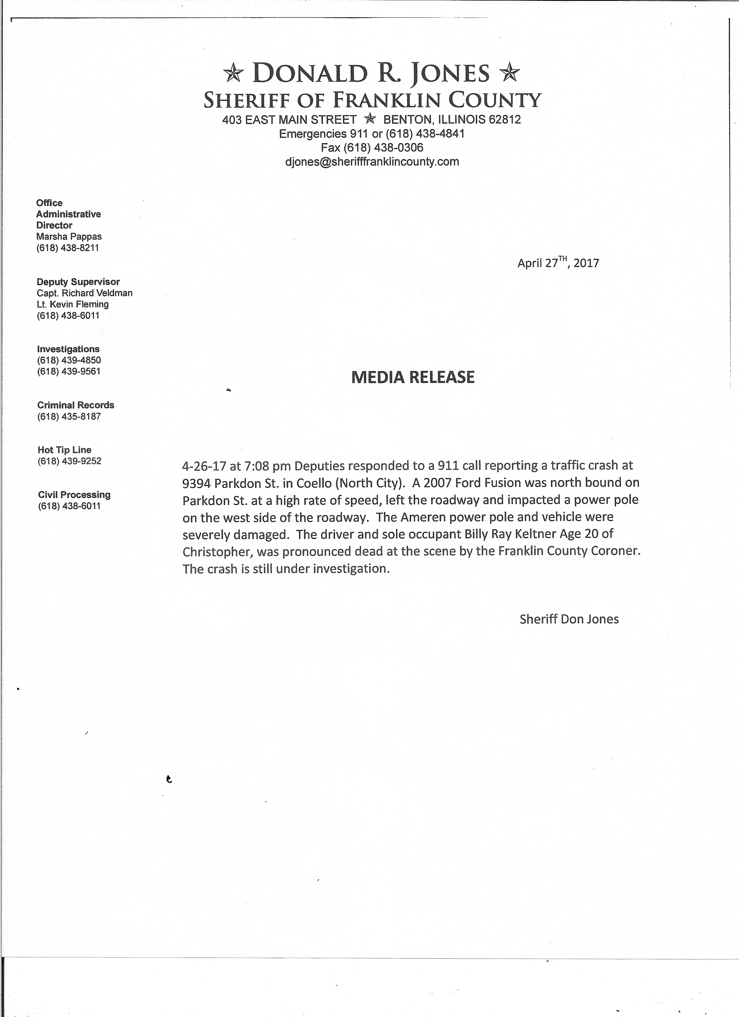
Christopher man killed in Coello Traffic crash

Press Release from the Franklin County Sheriff’s office scan0008

A lot of things to talk about…………..

by Steve Dunford 

First of all I would like to give a shout out to my son Andrew Dunford, who six years ago today as a twelve year old, started a Facebook page called Twister Weather.  He has quite the following.   Friday through Sunday are the days that he lives for.  He does a lot of work for Franklin County Emergency Management Agency during severe weather events.  I encourage you to follow his page.

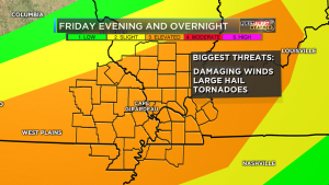
KFVS FIRST ALERT ACTION DAY FOR FRIDAY I'm getting more concerned with our severe weather threat Friday evening into the overnight hours. Large hail, damaging winds and tornadoes are all possible. Many of these storms will move in after sunset. Some of you could be sleeping! Please SHARE to keep your friends safe. It's always a good idea to have a couple ways to get warnings. The KFVS Weather App is great way to get those alerts and I also recommend a weather radio!!  (KFVS TV Meteorologist Laura Wibbenmeyer)

KFVS FIRST ALERT ACTION DAY FOR FRIDAY I’m getting more concerned with our severe weather threat Friday evening into the overnight hours. Large hail, damaging winds and tornadoes are all possible. Many of these storms will move in after sunset. Some of you could be sleeping! Please SHARE to keep your friends safe. It’s always a good idea to have a couple ways to get warnings. The KFVS Weather App is great way to get those alerts and I also recommend a weather radio!! (KFVS TV Meteorologist Laura Wibbenmeyer)

Lets deal with one thing at a time.   First the severe threat for tomorrow.  The Storm Prediction Center has all of Southern Illinois placed under an enhanced risk of severe weather.  The model the SPC has put out today places us under a 30% risk of severe weather with hatch marks, which means there is that probability of seeing a significant severe event 25 miles from your location.  Please view the caption to the left and read what Laura Wibbenmeyer, KFVS-TV meteorologist had to say about the situation.

Dr. Greg Forbes of the Weather Channel has the TORCON index for Southern Illinois as a three, which is consistent with the SPC.

As far as the severe threat for the rest of the weekend, on Saturday,  the borderline between a slight risk and a marginal risk for severe weather.  The slight-marginal line cuts through the heart of Southern Illinois and Franklin County.

On Sunday the Southern Seven counties are in an area outlined for severe weather.  This will not be given a category until tomorrow.

Starting Friday night through the weekend, there is a Flash Flood Watch issued for All Of Southern Illinois.   Here is the information on the watch from the National Weather Service of Paducah, KY

…MULTIPLE ROUNDS OF SHOWERS AND THUNDERSTORMS EXPECTED FRIDAY NIGHT THROUGH SUNDAY NIGHT…

…FLASH FLOOD WATCH IN EFFECT FROM FRIDAY EVENING THROUGH LATE SUNDAY NIGHT… The National Weather Service in Paducah has issued a * Flash Flood Watch for portions of southern Illinois, western Kentucky, and southeast Missouri, including the following areas, in southern Illinois, Alexander, Edwards, Franklin, Gallatin, Hamilton, Hardin, Jackson, Jefferson, Johnson, Massac, Perry IL, Pope, Pulaski, Saline, Union, Wabash, Wayne IL, White, and Williamson. In western Kentucky, Ballard, Carlisle, Fulton, Hickman, and McCracken. In southeast Missouri, Bollinger, Butler, Cape Girardeau, Carter, Mississippi, New Madrid, Perry MO, Ripley, Scott, Stoddard, and Wayne MO. *

From Friday evening through late Sunday night * The watch is generally in effect for locations along and west of a line extending from near Fulton, Kentucky to Mount Carmel, Illinois, including all of southeast Missouri. Much of this region has already received 1.5 to 3 inches of rainfall in the past 12 to 18 hours. Though things may tend to dry out a bit today and Friday, numerous thunderstorms with very heavy rain are expected to develop Friday night and then again Saturday night, Sunday and Sunday evening. There may be a break in the heavy rain threat during the day Saturday over western Kentucky, southwest Indiana, far southeast Missouri and the southern tip of Illinois. Several inches of rain are expected before all is said and done late Sunday night. The highest amounts are expected to fall from southeast Missouri into southwest Illinois. * In addition to the possibility of flash flooding, the heavy rainfall is expected to cause rises on many of the area rivers, particularly the smaller rivers in southeast Missouri such as the Saint Francis, Black, and Current.

PRECAUTIONARY/PREPAREDNESS ACTIONS… A Flash Flood Watch means that conditions may develop that lead to flash flooding. Flash flooding is a very dangerous situation. You should monitor later forecasts and be prepared to take action should Flash Flood Warnings be issued.


Benton, West Frankfort, Illinois News | Franklin County News