I-57 rest areas in Franklin County to be closed for several months

The Illinois Department of Transportation would like to alert motorists traveling on I-57 in Franklin County of upcoming rest area closures.

Beginning Wednesday, May 31, 2017 at 2:00 P.M., the Rend Lake north and southbound rest areas will be closed for extensive remodeling.

The rest areas are expected to reopen in the fall of 2017.

For IDOT District 9 updates on twitter, follow us at https://twitter.com/IDOTDistrict9

Summer Reading Safari sponsored by State Rep. Dave Severin

Students,

Thank you for taking interest in my Summer Reading Safari reading club! There are so many wonderful stories waiting to be read. I believe the earlier you start reading the more likely you are to become a lifelong reader. That being said, I am hoping you will pick up a couple books this summer and join my reading club! Please take some time to review the following rules.

  1. The Summer Reading Club is open to K-4th graders and asks that you read 8 books over your summer break.
  1. Once you complete the readings, fill out the form, have a parent or guardian verify that the books were read, and then return the form to Rep. Severin’s District office.
  1. Those who have read at least 8 books will be invited to participate in an ice cream party in the fall, hosted by Rep. Severin. The Representative will also provide legislative brochures about saving for College.

You can pick up a form at one of the local libraries or print out a brochure by clicking on the Summer Reading Safari graphic on the right hand side of the page, underneath the e-newsletter signup. Please return your reading forms by August 11th. My office can be reached through the contact form on my website ww.repseverin.com or by calling the office at (618) 440-5090.

Sincerely,

Dave Severin

State Representative,117th District

Benefit held in support of young girl with cancer

http://www.wsiltv.com/story/35536855/benefit-held-in-support-of-young-girl-with-cancer

BENTON, IL (Sean Conway, WSIL-TV  Please click to read the full story and watch the video.  Here is an excerpt)

Hundreds gathered at the Fraternal Order of the Eagles in Benton on Sunday for a benefit in support of a young girl recently diagnosed with an aggressive form of cancer.

10 year old Makanda Williams, of Macedonia, had been experiencing severe headaches on and off for the past year.

“It’s kind of like a mini-brain freeze, just for like 5 to ten minutes,” she said. “Then it goes away.”

Makanda was diagnosed with diffuse intrinsic pontine glioma (DIPG), an aggressive and rare childhood brain cancer. She said she has kept up her spirits while beginning her treatments.


Shooting in Benton yesterday – suspect at large

Local authorities are pursuing Alan Bennett, who left the scene after, a 40 year-old Benton resident obtained a gunshot wound.  The suspect is pictured above.

The shooting took place in the 1200 block of Anna street.

He is described as a white male with a bald head, standing 6’1 and weighing 250 lbs.

Bennett is a relative of the victim, according to police.

Authorities consider Bennett to be armed and dangerous. If you see him, do not approach him, call 911.

Anyone with information as to Bennett’s whereabouts can also call Benton Police at 618-435-8131, or your local law enforcement agency.

Summary of May 27 Severe Weather – Hail over golfball sized and winds upwards of 70 to 80 mph

National Weather Service- Paducah KY

http://www.weather.gov/pah/2017May27_SevereWeather

Radar Image as the storm crossed the river into Alexander and Union counties. (National Weather Service – Paducah KY)

NOTE:  Here in Franklin County we were spared for the most part, as we had a cell bearing down on us from the west that produced close to 110 mph winds in Central MO.

The most intense storm in the county was on the east side of the county in the Thompsonville-Akin area around 2:00 p.m.

The cell that prompted the Storm Prediction Center to use the term Hurricane Force Winds dropped to the southeast, going through Southeast Missori,  the Southern Seven counties of Southern Illinois and Western Kentucky.

The above link will take you to an interactive page of the National Weather Service.  Here is an overview of the event below from the NWS page.  -sd

Multiple rounds of severe thunderstorms impacted the Middle Mississippi Valley on the 1st day of the Memorial Day holiday weekend. Many observations of large hail and damaging winds were reported throughout the region, including wind speeds upwards of 70 to 80 mph and some hailstones measuring golfball sized and slightly higher.

There were multiple bowing segments that impacted the region with damaging winds the main impact from those. Each one seemed to develop further south than the one prior. Multiple individual cells and clusters also developed, especially early on in the event.

The brunt of the storms focused across southeast Missouri into much of southern Illinois and western Kentucky. Multiple rounds of storms over the same locations also resulted in some flooding issues requiring the issuance of a few flash flood warnings as well.

Rainfall totals of 1.5 to 3+ inches were observed from Carter County Missouri east into southern Scott County and into Carlisle and northern Graves Counties in Kentucky. The lowest amounts were up along the I-64 corridor and across the Evansville Tri-State area where only isolated heavier amounts were reported.


Legislation To Change Gender On Birth Certificate Passes House

http://peoriapublicradio.org/post/legislation-change-gender-birth-certificate-passes-house#stream/0

SPRINGFIELD, IL – (Brian Mackey – WCBU Radio, Peoria.  Click on the link above to read the full story.  Here is an excerpt below.)

Native Illinoisans would have an easier time changing the gender on their birth certificates, under legislation approved today in the Illinois House.  Under current law, only people who’ve had gender reassignment surgery can ask to change their birth certificates.

Several Republicans disagreed, saying the legislation would make it too easy to change one’s legal gender.  The measure passed narrowly… on a vote of 63 to 43.   It now goes to the Illinois Senate.

NOTE:  Area State Represenatives, Dave Severin (R -Benton), Terri Bryant (R-Murphysboro) and Brandon Phelps (D-Norris City) all voted against the measure.

IUOE wants passage of additional 15 cent gas tax in Illinois

http://www.wsiltv.com/story/35528946/labor-union-lobbies-for-15-cent-per-gallon-tax-on-gas

WSIL image

(Brandon Merano, WSIL-TV.  Please click on the link for the full story and video.  Here is an excerpt below.)

An Illinois labor union is pushing Senate President John Cullerton to introduce a 15 cent per gallon tax on gas.

That didn’t sit well with Carterville resident Tom Davis.

“You get taxed when you make your money, you get taxed when you spend your money and then you’ve got property taxes,” explained Davis.

Local 150 of the International Union of operating engineers is also pushing for a special tax assessment of electric vehicles because they don’t use any gas when driving on the roadways.


Severin Passes Senate Bill 730 through the House

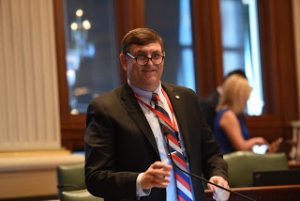
Springfield…. Today Representative David Severin (R-Benton) unanimously passed Senate Bill 730 through the Illinois House of Representatives, which extends the Petroleum Education and Marketing Act (PEMA). The Act was planned to expire on January 1, 2018 but will now be extended another 10 years to January 1, 2028.

“IPRB has done a great job of promoting the industry within Illinois,” Severin said. “Some of its other work includes the cleanup of abandoned tank battery sites around the state and developing new processes for remediating historic produced water spills. This extension should enable the IPRB to be of even better service to the public.”

The Act is governed by the Illinois Petroleum Resources Board (IPRB) who works closely with the Illinois Department of Natural Resources. The board’s purpose is mainly educational, working to inform the general public of the importance of the industry

Senate Bill 730 now heads to the Governor’s office and waits to be signed. Click here for the bill.

Marathon food drive aims to help local food banks

http://www.wsiltv.com/story/35520310/marathon-food-drive-aims-to-help-local-food-banks

WSIL image

WEST FRANKFORT, IL –(Sean Conway, WSIL-TV Please click on the link above to read the story and accompanying video.  Here is an excerpt below. )

Food pantries tend to thrive during the holiday season, but shelves tend to go bare as summer closes in. So a West Frankfort man decided to help with a “marathon food drive.”

Bill Cardin, of West Frankfort, just couldn’t let that happen. He became involved in the fight against hunger after learning just how many Americans struggle to eat.

“At least one in six people in this country go to bed hungry every night, and that’s just not okay with me” explained Cardin.

So he organized the first annual 5,000 Can Marathon food drive, using his contacts from several years of working with the Boy Scouts.

He says pantries thrive in the holiday season, but tend to suffer in the summer season.

“We found out when we brought the food to the food banks at that time, they were very happy to have it,” said Cardin. “And they said it was a great time for them up until about December people gave a lot of donations.”


Lake wind advisory for today/enhanced risk for severe weather tomorrow

by Steve Dunford 

Before we talk about tomorrow, we are going to take care of the business for today.  The National Weather Service has issued a Lake Wind Advisory from 10 a.m. this morning until 6 p.m. tonight. Below is the text from the national weather service in Paducah KY:

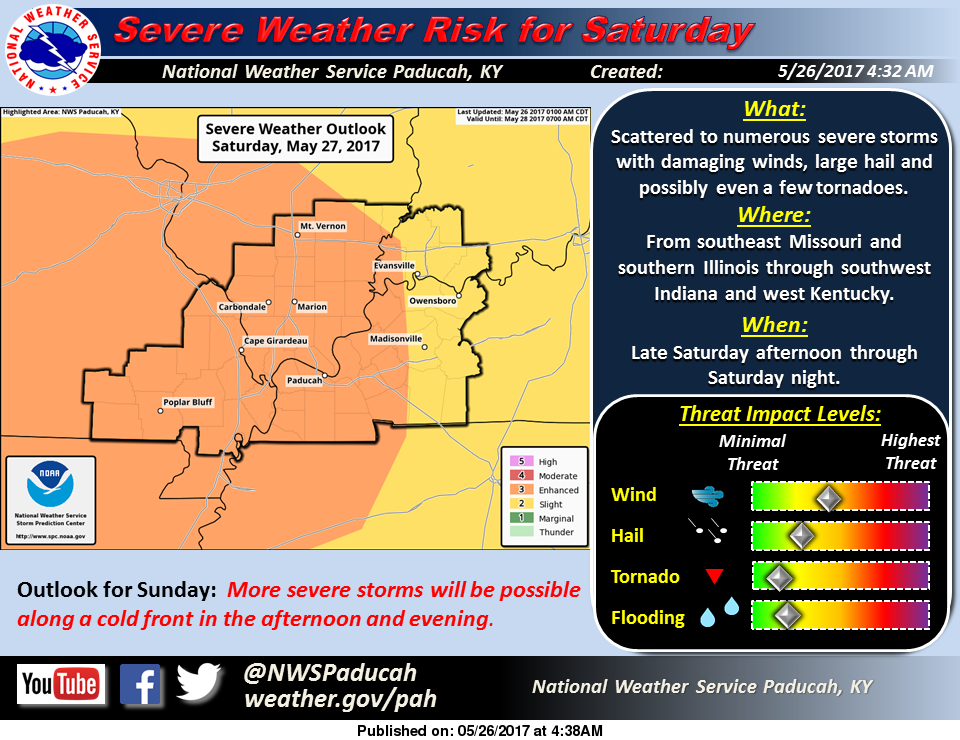
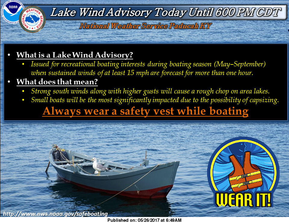
…LAKE WIND ADVISORY IN EFFECT FROM 10 AM THIS MORNING TO 6 PM CDT THIS EVENING…

The National Weather Service in Paducah has issued a Lake Wind Advisory, which is in effect from 10 AM this morning to 6 PM CDT this evening. *

TIMING…From late morning through the afternoon. *

WINDS…South winds will be sustained from 15 to 20 mph with gusts 20 to 30 mph. *

IMPACTS…Winds are expected to be strong enough to cause problems for boaters on area lakes. Small boats will be the most significantly impacted. Boaters on Kentucky Lake, Lake Barkley, and Rend Lake will be significantly impacted due to their extensive south fetches.

PRECAUTIONARY/PREPAREDNESS ACTIONS… A Lake Wind Advisory indicates that winds will cause rough chop on area lakes. Small boats will be especially prone to capsizing.

Spending several holiday weekends on Rend Lake, boat traffic will increase today with the upcoming holiday weekend.  The lake is usually choppy with the additional boats on the water.

With south winds gusting up to 30 mph, make sure your craft could handle the choppy waters.  Caution needs to be taken crossing the main body, especially south of route 154.

Randolph, Perry, Franklin, Hamilton, and White counties are on the southern edge of a marginal risk (level one of five) for severe weather today. There is a very slight chance of large hail and damaging thunderstorm winds.  The storm prediction center has the tornado threat near zero today.

There is only a 20% chance of showers and thunderstorms today and tonight, but for any that pop up they could turn severe pretty quick.  I would not alter any outdoor plans for today, I would just keep my eye to the sky.

We are still under an enhanced (level three of five) risk of severe weather for tomorrow.  The main threat will be in the late evening hours.  The atmosphere will be juiced tomorrow, with it hot, humid, and highs in the mid 80’s.

As you can see in the graphic above, straight line winds is the main threat.  The tornado threat is still minimal.  The risk for tornadic activity tomorrow would be a pop up storm in front of the main system.  A storm could go severe in a hurry and an outside chance a supercell could form.

Several are following a Facebook page, that has Franklin and surrounding counties in the bulls-eye for violent tornadoes.  If this was the case, the SPC would place us under at least a moderate or  a high risk of severe weather.  This system is to be very concerned about, but not to panic about.

I will be monitoring the situation tomorrow.  I now have NWS-chat access.  I will be able to see what the meteorologists in all three of the TV news outlets are saying, as well as local emergency management officials.  I count it an honor to be entrusted with this, and will be able to provide better severe weather coverage.

Below is the hazardous weather outlook issued by the NWS in Paudcah.

.DAY ONE…Today and Tonight A few thunderstorms will spread eastward into southeast Missouri early this morning. They should dissipate by 10 AM before reaching the Mississippi River. Lightning will be the primary concern. Small chances of thunderstorms are forecast tonight, mainly along the Interstate 64 corridor of southern Illinois and southwest Indiana. A few severe storms with large hail and damaging winds will be possible if storms can develop.

.DAYS TWO THROUGH SEVEN…Saturday through Thursday Thunderstorms are forecast throughout the region Saturday through Sunday evening. Any storms that develop through this period may become severe, but the greatest threats will be late Saturday into Saturday night, and possibly again along the cold front Sunday afternoon and evening.

The latest guidance suggests that one or more thunderstorm complexes may move through the region with primarily a damaging wind threat. Any individual storms would pose a threat of very large hail to go along with damaging winds and possibly a few tornadoes.

In addition, heavy rainfall may lead to flash flooding where multiple storms train over the same locations. Small chances of afternoon and evening thunderstorms are forecast for all or a portion of the region Tuesday and Wednesday. Better chances of thunderstorms are forecast throughout the area Thursday and Thursday night. Locally heavy rainfall and lightning will be the primary concerns.

.


Benton, West Frankfort, Illinois News | Franklin County News