Keep your eye to the sky-especially during the overnight hours

Enhanced 2-28

This is the first of three Storm Prediction Center graphics I am sharing.   This one means there is a 10% chance of having a tornado 25 miles in any point of the yellow.  The hatch marks represent the potential of tornadoes being an F-2 or greater.

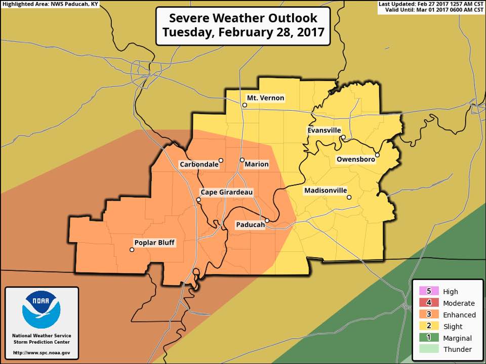
This is the first of two Storm Prediction Center graphics I am sharing. This one means there is a 10% chance of having a tornado 25 miles in any point of the yellow. The hatch marks represent the potential of tornadoes being an F-2 or greater.

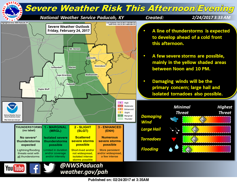
The threat of severe weather for tonight has been discussed for the last 48 hours or so.  Most of the models that I have looked at this morning will show some cells that will from in front of the main squall line after dark.  Most models show the squall line coming through around 3:00 a.m. tomorrow morning.

Those cells that form in front of the line

he TORCON values for toinght shows a 40% chance of receiving Tornadic Activity 50 miles or less from Franklin County (Dr Greg Forbes- The Weather Channel.)

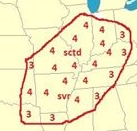
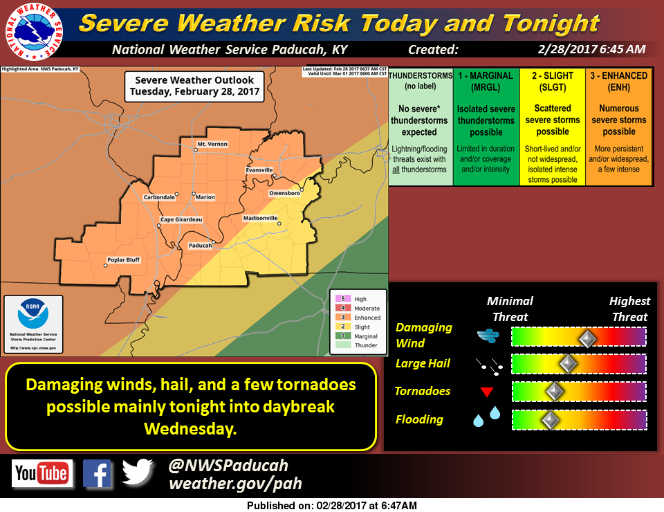
The TORCON values for toinght shows a 40% chance of receiving Tornadic Activity 50 miles or less from Franklin County (Dr Greg Forbes- The Weather Channel.)

have the potential to become super-cells with the greatest risk of any tornadic activity in front of the line.

The greatest threat in the squall line will bed damaging thunderstorm winds.  Large hail and an inbedded Tornado can not be ruled out.

I am not saying things to alarm anyone, or scare anyone.  This system really had my attention since about mid day yesterday.

The second of three graphics from the SPC.  There is a 30% chance of seeing a severe wind event (60+ mph) 25 miles from Franklin County tonight.  The same percentage exists for quarter size hail or greater.

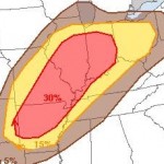
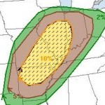
The is the second graphic from the SPC. There is a 30% chance of seeing a severe wind event (60+ mph) 25 miles from Franklin County tonight. The same percentage exists for quarter size hail or greater.

The potential does not mean it is going to happen, however preparedness is vital in an actual event.

Soon, there will be a Tornado preparedness guide posted on the website produced by FEMA, that Franklin County Emergency Management Agency Director Ryan Buckingham posted through the agency’s media sources.  Please review this for a refresher.

As long as there is a severe weather threat for Franklin County,  I will be up all night monitoring the situation to keep you informed.  Warnings from 75-100 miles out that any part of the county is potentially in the path of the storm, will be posted on the franklincounty-news.com’s Facebook page.  There will be updates on the website from time to time however.

Costello says FOID cards are an ‘extra burden’ for law-abiding Illinoisans

State Represenative Jerry Costello II (D - Smithston) files legislation to end the FOID card registration in Illinois

State Represenative Jerry Costello II (D – Smithston) files legislation to end the FOID card registration in Illinois

SPRINGFIELD, IL (Kelsey Landis and Dana Reick – Belleville News Democrat Click on the link to read the entire story. Here is an excerpt) A state representative from Smithton has filed a bill that would eliminate the Firearm Owner’s Identification card, which is needed to buy or possess a gun and purchase ammunition in Illinois. Rep. Jerry Costello II, a Democrat, says FOID cards are a burden to “responsible” Illinois residents and prevent them from obtaining firearms and exercising their Second Amendment rights. “My job as a public official is to make sure the constitution is followed,” Costello said Friday. “… Obviously, I’m passionate about the Second Amendment, and people living under our constitution are allowed to bear arms.

RLC to host first women’s Concealed Carry class

INA, Ill. (Feb. 27, 2017) – Next month, Rend Lake College is offering a new option for local women to obtain their Illinois Concealed Carry permit. On Friday, March 17 and Saturday, March 18, the first women’s only Concealed Carry class will be open to any woman over the age of 21.


Ron Meek, RLC Criminal Justice Associate Professor and instructor for the Concealed Carry class, said there are several reasons for the college to host a women-only event.

“This class has been recommended by many female RLC employees and faculty to reduce the intimidation factor and make the class one gender,” said Meek. “This setting allows us as instructors to tailor the class specifically to the audience.”

On day one, the firearms safety and marksmanship classroom portion of the course will focus on safety, principles of marksmanship, loading and unloading, cleaning, and state and federal laws relating to firearms and force. Firearms and ammunition are not to be brought to this class.

The second day will include interacting with law enforcement, recognizing risk factors and situational awareness, identifying threats, and learning about range rules and procedures. The live fire practice and qualification will also occur on the RLC Shooting Range. Students should bring their firearm with 100 rounds of unopened ammunition to be inspected by course instructors.

The class will meet 4 – 10 p.m. Friday and 8 a.m. – 6:30 p.m. Saturday. All classes will meet instructors Meek and Jeff Bullard in the Coal Mine Training Center, Room 107A, on the Ina campus.

The two-day program prepares students to apply for their permit. To qualify, students must complete 30 rounds at 5, 7, and 10 yards with at least 70 percent accuracy. A qualifying shot consists of a shot placed inside the 7 ring of a B-27 target.

Participants who complete RLC’s Concealed Carry training course are eligible to apply for Illinois and Florida Concealed Weapons licenses. A valid FOID card and a driver’s license must be brought to class. Students must attend the entire 16 hours of training, no exemptions will be given. The cost of the training is $150 for in-state residents and $250 for out-of-state residents.

Two additional Concealed Carry classes for any gender are also on the books for later this year: Saturday, May 20 – Sunday, May 21; and Friday, Aug. 4 – Saturday, Aug. 5.

To learn more or to register, contact RLC’s Community and Corporate Education Division at 618-437-5321, Ext. 1714.

Severe Weather Prepardness

We are entering severe weather season, even though we can have an event year round, the springtime is the time we can have the most threat. Ryan Buckingham, director of Franklin County Emergency Management agency released this article from FEMA that discusses severe weather reminders. Please click on the link to read the FEMA handout.

Tuesday Night/Wednesday morning severe weather threat needs to be taken serious.

February 28

I am going to make a format change to the page.  I will only post weather updates when there is a potential hazard on the horizon.

Today it is going to be mostly cloudy with a high in the upper 50’s. There is a chance of thunderstorm over night with a low around 50.

There is a 30% chance of thunderstorms tomorrow afternoon with a high in the lower 70’s.

After dark is where things can get interesting.  There is an 80 percent chance of thunderstorms.  In the graphic, the enhanced risk of severe weather cuts right through Franklin County.

Here is the hazardous weather outlook issued by the National Weather Service in Paducah, KY.

.DAY ONE…Today and Tonight Thunderstorms enter the forecast later tonight, with heavy rain and lightning the primary anticipated storm related hazards. There is a marginal risk of severe storms, mainly for hail, just to our west, and affecting the far western Ozarks in southeast Missouri, late tonight. .

DAYS TWO THROUGH SEVEN…Tuesday through Sunday Thunderstorm chances spike Tuesday and Tuesday night, as we warm sector ahead of an approaching cold front. The increasingly unstable air-mass will be fortified by near record high temperatures in the 70s during the daytime Tuesday. There continues to be an enhanced risk of severe storms for southeast Missouri and adjacent portions of southwest Illinois and far southwest Kentucky, mainly Tuesday afternoon and evening into Tuesday night, with a slight risk of severe storms across the remainder of the area. Damaging winds will be the primary severe weather hazard, but large hail and isolated tornadoes may also be a possibility. Locally heavy rains and frequent lightning will accompany thunderstorms as well. The cold front makes its passage late Tuesday night and early Wednesday morning.

Depending upon its timing, the threat of severe storms may linger into Wednesday morning. As a result, a marginal risk of severe storms lingers south of the Ohio river early Wednesday, with a slight risk of severe storms east of the Lakes in western Kentucky, likewise lingering early Wednesday. Damaging winds will be the primary severe weather hazard, but large hail and isolated tornadoes may also be possible until the front makes its passage in entirety. Locally heavy rains and frequent lightning will accompany thunderstorms as well.

Rick Shanklin Head Meteorologist with the NWS in Paducah made the following statement on his Facebook page.  “This bares watching – from late tomorrow into Wednesday morning. Per SPC “…supercells with all hazards possible, including the conditional possibility for a strong tornado(s)..” Stay up to date at weather.gov/PAH or your favorite media source.

As of now, it looks like a 3:00 to 7:00 a.m. time frame Wednesday morning when Franklin County will be under the gun.

Shanklin repeatedly refers to this area as nocturnal tornado alley.  We have our strongest and deadliest tornadoes in the overnight hours.

I will be up as long as I have to tomorrow night the radar and will start passing along warnings if Franklin County is in the path of a storm 100 miles out.  I will be in contact with Franklin County Emergency Management agency if any information needs passed along as well.

Showers will linger around for Wednesday.  Thursday and Friday will be seasonal, with highs in the lower 50’s.  The early spring will return for the weekend with highs back up in the 60’s.-sd


Durbin In Poland, Lithuania, Ukraine To Discuss NATO, Russia

WARSAW, POLAND—U.S. Senate Democratic Whip Dick Durbin is in Poland today, as part of travel to three eastern European nations to discuss Russian aggression and interference in western democracies, and congressional support for the transatlantic relationship and the North Atlantic Treaty Organization (NATO).

Durbin was joined by U.S. Senator Jeanne Shaheen (D-NH) in Warsaw for meetings with senior government officials.

In Vilnius, Lithuania, Durbin will meet with President Dalia Grybauskaite, Parliamentary leaders, and U.S. forces working with their Lithuanian counterparts.

In Kyiv, Ukraine, Durbin will be joined by U.S. Congressman Mike Quigley (D-IL) for meetings with Prime Minister Volodymyr Groysman, and other senior government officials.

“Eastern Europe and the transatlantic alliance are at critical moments in their history. We must support our allies who face the brunt of Russian cyberattacks, propaganda, military intimidation, and even invasion in the case of Ukraine. But President Trump’s disturbing  defense of Russia only emboldens Putin and further threatens to destabilize these critical democratic nations in the region,” said Durbin. “Our meetings here will focus on concerns with the ongoing assault on Ukraine as well as the continued threat of Russia, and the need for transatlantic unity on defense cooperation and sanctions. The Baltic States, Poland, Ukraine, and others in the region have friends in Congress and around the world, and together we will continue to stand with them.”

Severin Votes to Deny Lawmakers a Pay Increase

Press release from State Representative Dave Severin (R-Benton)

SPRINGFIELD, IL – State Representative Dave Severin (R-Benton) voted to deny state lawmaker pay increases during a meeting of the House Executive Committee on Thursday morning. The Benton Republican and first-term lawmaker had filed an identical piece of legislation, HB 3790.

“House Bill 643 will deny lawmakers an increase in pay, based on a cost-of-living adjustment allowed by the Compensation Review Act,” Severin said. “Lawmaker pay is currently treated as a continuing appropriation and cost of living adjustments, or raises, are built in to that law. It’s completely ludicrous, but, each year the General Assembly has to actually take a vote to stop its own automatic pay raise. If you consider the utter failure of the legislature to produce balanced budgets for the last several years, the notion that automatic pay raises for politicians would be possible is just insane to me. That’s why today’s vote was so important.”

The bill applies only to the fiscal year 2018, beginning July 1, 2017. The bill passed Committee unanimously and now heads to the full House for a vote.

Marginal risk for severe weather today


NWS Febuary 24

Franklin County and the rest of Southern Illinois has been downgraded to marginal risk of severe weather today.  We are not out of the woods, but the treat has diminished.

We have one more day left of the early spring, as highs today will be in the lower 70’s.

The National Weather Service in Paducah, KY issued this statement about the potential for severe weather today:

A chance of thunderstorms exists primarily this afternoon and evening ahead of an approaching cold front. This includes a slight risk of severe storms, mainly over southwest Indiana and the Pennyrile of western Kentucky. Damaging winds will be the primary severe weather hazard, but large hail and isolated tornadoes will also be potential hazards.

Tomorrow more February type weather will come into the forecast, with a high around 40.  The fire danger will be elevated tomorrow. Here is a statement from the National Weather Service addressing this:

Fire danger spreads across the entire Quad State Saturday afternoon, due to a combination of winds in the teens mph and low relative humidity values in the 30s percentile.

The potential for thunderstorms returns to all or part of the area Tuesday and Tuesday night. The main storm related hazards will be lightning and locally heavy rain.

There will be a chance of rain each day Sunday through Wednesday as temperatures moderate to the mid 60’s by Tuesday.  Highs will be in the 50’s Wednesday and Thursday.

State Rep. Severin announces 2017 Online Legislative Survey

2017 survey button red (1)Press release from State Representative Dave Severin (R-Benton)

Illinois is facing incredibly difficult times, and it will require us to make some tough decisions. As your State Representative, it is important for me to know how you feel about these issues. I invite you to weigh in with your opinions and comments by taking my online survey. In the survey you will find questions ranging from the budget impasse to gun rights issues, as well as a short essay question where you can give us your ideas on what needs to change in Springfield.

Please fill out all of the contact information so I can keep you in the loop on these issues throughout the year. Click here to fill out the survey.  


Winner of $11 million lotto ticket sold in Benton, IL identified

Illinois Lottery Photo

Donald Wendell of Benton showing his winning ticket – Illinois Lottery Photo

BENTON, IL – (Alycia Dombrick KFVS-TV Please Click to read the entire story. Here is an excerpt- Donald Wendell of Benton, Illinois is the state’s newest multi-millionaire. Wendell won $11,250,000 when his $1 Quick Pick ticket matched all six numbers (02 – 21 – 33 – 36 – 37 – 41) in the Monday, Feb. 13, Lotto drawing. “I think I’m in shock!” he said when he presented his winning ticket at the Illinois Lottery Prize Center in Fairview Heights. Wendell was at Circle K, 224 N. Main St., in Benton, putting gas in his truck when he bought the winning ticket. “I buy a ticket once or twice a week and I always joke with the clerks and say, ‘You sold me the winning ticket, right?’ Well this time they actually did!”

Benton, West Frankfort, Illinois News | Franklin County News