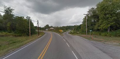
View of St. Route 149 going east to west. Growing up in Thompsonville, I more than realize the danger of this intersection. I am glad some reconstruction will be done to it. -sd (Google Maps image)
Benton, West Frankfort, Illinois News | Franklin County News
Newspaper covering Franklin County, Illinois
View of St. Route 149 going east to west. Growing up in Thompsonville, I more than realize the danger of this intersection. I am glad some reconstruction will be done to it. -sd (Google Maps image)

A few of several campers at a Sparta scrapyard waiting for demolition. (Randolph County Journal photo)

Kevin Shuman
On March 23, at 4:13 p.m. a traffic stop in West Frankfort resulted in the arrests of Kevin W. Shuman, 40 of Benton, and Monte Johnson, 33 of West Frankfort.
Shuman was charged with driving with license suspended, possession of methamphetamine and drug paraphernalia. Shuman was also wanted on a warrant for failure to appear on a previous felony arrest involving drug activity.

Monte Johnson
Johnson, who is on parole, was charged with possession with intent to deliver ecstasy (a class X felony) possession of a handgun by a convicted felon, possession of drug paraphernalia and possession of a controlled substance.
Both are being held in the Franklin County Jail pending review by the States Attorney’s office and further investigation. More charges and arrests are possible.
OTHER ARRESTS
On March 18th., a traffic stop in West Frankfort, resulted in the arrest of John Ladd, 33 of West Frankfort, for driving while license were suspended.
On March 19th., a traffic stop in West Frankfort, resulted in the arrest of Steven R. Johnson, 29 of West Frankfort, for possession of drug paraphernalia.
On March 20th., a traffic stop in Royalton resulted in the arrest of Joni R. Williams, 32 of Royalton for driving while license suspended.
On March 20th., deputies responded to a domestic dispute in Royalton that resulted in the arrest of Terry L. Leonard, 36 of Royalton for domestic battery.
WARRANT ARRESTS
On March 15th., Braden Eubanks, 31 of Benton, for failure to appear on a traffic charge.
On March 16th., Jeremy Toth, 29 of Benton, for criminal trespass to a vehicle.
On March 17th., Catherine Meeks, 57 of West Frankfort, for failure to appear on traffic charges.
On March 23rd., Tyler Morlan, 23 of Sesser, for failure to appear on domestic battery charges.

Rachel Rabe (center) with Founder and Guild CEO Tim Morthland (left) and President Glenn Poshard (Right) (WSIL Photo)
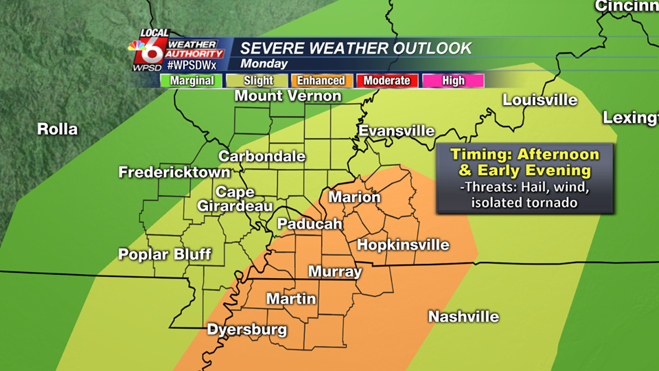
WPSD TV- Paducah KY graphic
As you can see in the graphic above, Franklin County is split between the area of having a slight to a marginal risk for severe weather.
The main threat for today’s storms is damaging thunderstorm winds. There might be some small hail. The tornado threat at this time is minimal.
The main ingredient today will be instability. We have a line of storms that are on top of us now. These will be non severe with some rumbles of thunder. If the sun comes out after these and juices the atmosphere, the severe threat today will be much greater.
Here is the hazardous weather outlook from the National Weather Service in Paducah, KY
.DAY ONE…Today and Tonight Thunderstorms are possible over all or part of the outlook area today and tonight. A few storms may become severe mainly this afternoon and evening with damaging winds and large hail being the primary hazards. A tornado or two is not out of the question. Otherwise locally heavy downpours and lightning will be the primary hazards.
.DAYS TWO THROUGH SEVEN…Tuesday through Sunday Thunderstorms are possible over all or part of the outlook area Wednesday night, Thursday, and Thursday night. Widespread severe weather is not expected at this time. Locally heavy downpours and lightning will be the primary hazards.
From early this afternoon on, I will be able to keep you informed. The Facebook page will be the best way to receive watches and warnings. I will try to put them on the website as well if time allows. -sd
 The Storm Prediction center in Norman OK has Southern Illinois placed under a slight risk of severe weather for tomorrow. The slight risk boundary runs from points south and east from Chester to Mt. Carmel.
The main threat, for tomorrow afternoon and evening, will be large hail and damaging winds. Here is the latest hazardous weather outlook from the National Weather Service in Paducah KY.
.DAY ONE…Today and Tonight Thunderstorms are possible over all or part of the outlook area late tonight. Locally heavy downpours and lightning will be the primary hazards.
.DAYS TWO THROUGH SEVEN…Monday through Saturday Thunderstorms are possible over all or part of the outlook area Monday through Monday evening. A few storms may become severe during the afternoon and evening hours with damaging winds and large hail being the primary hazards. Otherwise Locally heavy downpours and lightning will be the primary hazards. Thunderstorms are possible over all or part of the outlook area from Wednesday night through Thursday. Locally heavy downpours and lightning will be the primary hazards.
Please follow the Facebook page throughout the day for updates on the potential for tomorrow.

Trayvon Johnson who is wanted for multiple crimes including attempted murder in Perry County. He is believed to be in the Carbondale area.
