Flooding hits the county overnight

by Steve Dunford 

Flooding last night on Route 37 South near St. Louis Street in West Frankfort. (Image by WSIL Meteorologist-Storm Chaser Tony Laubach

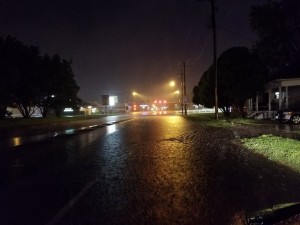
Flooding last night on Route 37 South, near St. Louis Street in West Frankfort. (Image by WSIL Meteorologist-Storm Chaser Tony Laubach

Flash flooding caused havoc overnight across the county as four to six inches of precipitation fell. Most of the rain was in the southeast corner of the county in the West Frankfort-Thompsonville areas.   Just to our immediate south, there were evacuations in Herrin

According to a spokesman from the Franklin County Sheriff’s office, Yellowbanks at the Big Muddy River, and Deering Road (18 Bottoms) are closed.  Two other flood prone areas Park Street and Peach Orchard road, crossing the Little Muddy at the Perry County line are still open, as the northwest corner of the county.

A representative from the West Frankfort Police Department said the flood plain in the Northwest park of the city is flooded this morning.  There was only one evacuation that took place. The pumps installed after the Flood of ’93 are working properly.  Two more pumps are coming from Eldorado to help the water recede.

A lot of the rural roads in Cave township  have water over the road in flood prone areas, near West Frankfort Lake  and Southeast of Thompsonville.

I contacted the Saline County Sheriffs office to check on the condition of Route 34 between Galatia and Thompsonville where it floods in the bottoms, just east of West End. There is water over the road near the intersection of Rileyville road and near the Harco blacktop.  Route 34 is still open, however.

The Sheriff’s office also included that if someone was heading to Harrisburg from this direction, stay with Route 34 instead of the Harco Blacktop, as he described it a mess. They said that water is over the road around American Coal, was closed for a while, but back open.

There is a Flood Warning in effect for Franklin County until 2:30 p.m. that replaced the Flash Flood Warning.  If you are out and about, please follow the principle of go around, don’t drown.

Severe Thunderstorm watch until 5 AM for most of Southern Illinos

ww0172_radar
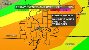
The Storm Prediction Center has issued a Severe Thunderstorm Watch until 5am for all counties in Southern Illinois with the exception of Randolph, Perry and Massac.  Here is the information for the watch below.

The NWS Storm Prediction Center has issued a * Severe Thunderstorm Watch for portions of Northwestern Arkansas Southern Illinois Southern Missouri Northeast and east central Oklahoma

* Effective this Friday night and Saturday morning from 1000 PM until 500 AM CDT.

* Primary threats include… Scattered large hail likely with isolated very large hail events to 2.5 inches in diameter possible Isolated damaging wind gusts to 70 mph possible A tornado or two possible

SUMMARY…Thunderstorms will gradually increase in coverage and intensity in a band from southern Illinois to southern Missouri/northwestern Arkansas and adjacent parts of eastern Oklahoma, and the storms will persist well into the overnight hours. Supercells will be possible within the broader area of convection, which will locally enhance the risk for large hail and damaging winds. Though most of the storms will be rooted slightly above the surface, and isolated tornado or two cannot be ruled out overnight.

The severe thunderstorm watch area is approximately along and 35 statute miles north and south of a line from 80 miles east of Carbondale IL to 60 miles southwest of Tulsa OK.

PRECAUTIONARY/PREPAREDNESS ACTIONS… REMEMBER…A Severe Thunderstorm Watch means conditions are favorable for severe thunderstorms in and close to the watch area. Persons in these areas should be on the lookout for threatening weather conditions and listen for later statements and possible warnings. Severe thunderstorms can and occasionally do produce tornadoes.

I will keep you updated as long as there is a severe threat for Franklin County.


Orient man arrested on sex offender charge

Press Release from the Franklin County Sheriff’s office

Alan Marsh

Alan Marsh

On April 28th at 3:40 pm, Deputies arrested Alan T. Marsh, 56 of Orient, for violations of the Sex Offender Registration Act.  Marsh is a registered sexual predator.

The arrest was made in Benton.  Marsh is being held in the Franklin County Jail in lew of $15,000 bond.

Herrin man arrested on sexual abuse of minor charges

Press Release from the Franklin County Sheriff’s office 

Joseph Ryker

Joseph Ryker

On April 28, 2017 at 12:00 p.m. Franklin County Sheriff’s Investigators, assisted by Deputy United States Marshalls arrested Joseph A. Ryker Age 26 of Herrin. The arrest was made on the campus of Rend Lake Community College. The arrest was made on a warrant charging six counts of aggravated criminal sexual abuse (class 2 felonies), one count of indecent solicitation of a child (class 3 felony) and one count of grooming (class 4 felony). The victim is a 15 year old high school student. Ryker is being held in the Franklin County Jail in lieu of $250,000.00 bond. The investigation is continuing and more charges and arrests are possible.

Another I 57 wreck

Picture provided by Amanda Smith to KFVS C-News.

Picture provided by Amanda Smith to KFVS C-News.

According to several social media reports, media, and the Illinois State Police there has been a semi accident on I 57 southbound, between the 73 and 74 mile markers.  This is just north of the Benton exit.  The accident occurred around 3 pm.

Traffic was backed up in both lanes, and now one lane is open.  Seek alternate routes.

sd

Update on the weather situation

by Steve Dunford 

mcd0577
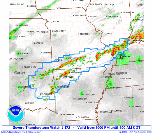
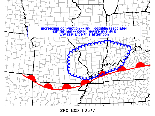
First of all everything from my previous post applies.  The Storm Prediction center currently has All of Southern Illinois under a meso (which means Mesoscale Discussion).  This is an area the SPC monitors for watch issuance.  (See graphic above)

There is a strong possibility a watch will be issued over the next two hours for Southern Illinois.  In my opinion, most likely it will be a Severe Thunderstorm Watch. However, I would not be a bit surprised if a Tornado Watch would be issued.

There are a couple cells that is firing in Southeast Missouri.  There is one in that has has prompted a Severe Thunderstorm Warning.  If it stays together, it has the potential to go through parts of Randolph, Perry, and Jefferson Counties.

I am keeping an eye on a cell that is in Cape county at the time that has the potential to move into Franklin County that could affect some afternoon sporting events.  Grant Dade put the track on it, and it has the potential to reach Carbondale at 2:30.

I am watching what this does as it crosses the river.  During a severe weather event, please check the Facebook page and your favorite media source.  Things develop too quickly to post on the website, but I  will make the effort.


Keep your eye to the sky through the weekend

by Steve Dunford 

SPC places Southern Illinois at level 3 for Severe threat. We believe focus time is later day and overnight. Look for live stream as storms approach. (WSIL TV Chief Meteorologist Jim Rasor)

SPC places Southern Illinois at level 3 for Severe threat. We believe focus time is later day and overnight. Look for live stream as storms approach. (WSIL TV Chief Meteorologist Jim Rasor)  A personal note from me.  We have three very good weather teams in this market.  You will not go wrong with channels three, six or twelve.  Personally during a severe weather threat, I always monitor channel 12 first, then when it approaches Southern Illinois, I flip between the two. )

Over the next seventy two hours we will have a risk for severe weather over the weekend.  Today is an enhanced risk and Saturday and Sunday is a slight risk.

The main reason we are under an enhanced risk today is the risk for large hail.  Damaging thunderstorm winds and isolated tornadoes will be a risk throughout the weekend.

This is a storm system that will be a challenge to forecasters.  We have an advancing warm front that will become stationary across the region.  It will convert into a cold front and pass the region sometime on Sunday.

This will wobble back and forth.  Right now with cloud cover and around 60 degrees I am wondering if the front has gone stationary right now and we are in the cold sector.  As long as the cloud cover remains, there will be a cap among the atmosphere.  Looking at the latest radar, I would say the front is in the route 50 corridor now.

For high school sporting events  as long as the cloud cover remains, we should get the games in with some passing sprinkles.  If the sun pops out, it might be another Athletic Director’s nightmare as pop up thunderstorms could form.

This is one of those forecasts that will be updated frequently.  That is why it is important not to have fear but be aware over the weekend.

There is a site out there on social media that has a doomsday scenario painted for a few Southern Illinois counties, including Franklin for the overnight hours.  This is over-sensationalized, and borderline being fake.  There is a threat for the possibility of severe weather, and make sure you have your NOAA weather radios on tonight, be aware, but don’t be alarmed until you have to.

We are going to get a lot of rain over the weekend, how much is varying by the models.  There are some that is as few as three inches, some as high as seven.

At this time the pool at Rend Lake is 407.1 ft, that is going over the spillway swiftly At 410′ is when concern should start, as water will be flowing over the entire spillway.

The Big Muddy at Plumfield is at 13.2 feet now.  It will not reach flood stage until sometime late Saturday or Sunday, which is 20 feet.  It is forecasted to crest late Monday afternoon at 22.7 feet.

Below is the information on the  Flash Flood Watch and hazardous weather outlook from the National Weather Service from Paducah, KY.

…FLASH FLOOD WATCH REMAINS IN EFFECT FROM THIS EVENING THROUGH LATE SUNDAY NIGHT… The Flash Flood Watch continues for * Portions of southern Illinois, western Kentucky, and southeast Missouri, including the following areas, in southern Illinois, Alexander, Edwards, Franklin, Gallatin, Hamilton, Hardin, Jackson, Jefferson, Johnson, Massac, Perry IL, Pope, Pulaski, Saline, Union, Wabash, Wayne IL, White, and Williamson. In western Kentucky, Ballard, Carlisle, Fulton, Hickman, and McCracken. In southeast Missouri, Bollinger, Butler, Cape Girardeau, Carter, Mississippi, New Madrid, Perry MO, Ripley, Scott, Stoddard, and Wayne MO. * From this evening through late Sunday night *

The watch is generally in effect for locations along and west of a line extending from near Fulton, Kentucky to Mount Carmel, Illinois, including all of southeast Missouri and southern Illinois. Much of this region already received 1.5 to 3 inches of rainfall Wednesday and Wednesday night. Numerous thunderstorms with very heavy rain are expected to develop later this afternoon and continue tonight. Some areas of western Kentucky and the southern tip of Illinois may see a break in the precipitation Saturday into Saturday night, but will then see more thunderstorms with very heavy rainfall move in from the west late Saturday night and through the day Sunday. From 3 to 6 inches of rain could fall in the watch area by the time the entire event is finished Sunday night. Locally higher amounts are also possible where numerous thunderstorms repeat. * In addition to the possibility of flash flooding of some roadways and streams, the heavy rainfall is expected to cause rises on many of the area rivers, particularly the smaller rivers in southeast Missouri, such as the Saint Francis, Black, and Current

. PRECAUTIONARY/PREPAREDNESS ACTIONS… A Flash Flood Watch means that conditions may develop that lead to flash flooding. Flash flooding is a very dangerous situation. You should monitor later forecasts and be prepared to take action should Flash Flood Warnings be issued.

Flood Warning National Weather Service Paducah Kentucky 948 AM CDT Fri Apr 28 2017 ...

The National Weather Service in Paducah, Kentucky has issued a flood warning for a portion of the Big Muddy River affecting areas in southwest Illinois… Near Plumfield affecting Franklin and Williamson Counties. .Due to heavy rainfall across the river basin over the past couple of days, and anticipated rainfall expected over the weekend, water levels are expected to rise above flood stage along the Big Muddy River near Plumfield later this weekend and crest early next week. PRECAUTIONARY/PREPAREDNESS ACTIONS… SAFETY MESSAGE… Never drive cars…trucks or sport utility vehicles through flooded areas. The water may be too deep to allow safe passage. Never allow children to play in or near flood waters. Stay tuned to NOAA Weather Radio or your local media for further statements and possible updated forecasts.

This Hazardous Weather Outlook is for portions of southern Illinois, southwest Indiana, western Kentucky, and southeast Missouri. .

DAY ONE…Today and Tonight Scattered severe thunderstorms will be possible this afternoon and tonight over the entire quad state region. Very large hail be possible in the stronger storms, along with damaging wind gusts. Isolated tornadoes will also be possible. In addition, a Flash Flood Watch is in effect for all of southern Illinois, southeast Missouri and the western tip of Kentucky this evening through Sunday evening. From 3 to 6 inches of rainfall may occur over the course of the weekend. East of the watch, additional rains of 1 to 3 inches may occur. Please refer to the watch product for more details. .

DAYS TWO THROUGH SEVEN…Saturday through Thursday A Flash Flood Watch will remain in effect through Sunday evening for multiple rounds of thunderstorms containing very heavy rain. Please refer to the watch product for more details. In addition, scattered severe thunderstorms will continue to be possible periodically through much of the weekend. Large hail and damaging wind gusts are expected to be the main hazards. However, isolated tornadoes cannot be ruled out. There is a chance of thunderstorms over the southern third of the Outlook area on Wednesday. Any storms that develop are not expected to be severe at this time.


Governor Connects with Students Across Illinois on Facebook Live

Press Release from Governor Bruce Rauner’s office

GOvenor with Riverton kids
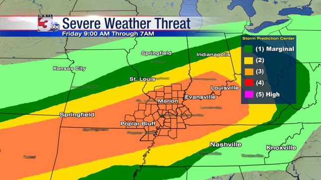
SPRINGFIELD – Governor Bruce Rauner today hosted a Facebook Live to connect with students across Illinois for an interactive, virtual school visit. Students from nearby Riverton also joined the Governor at the Capitol.
“By far, my favorite thing to do as governor is visit with students and teachers across the State of Illinois,” Governor Rauner said. “Thanks to technology and social media, we were able to connect with more classrooms than ever before.”
Governor Rauner took questions from students and teachers from Rockford, Momence, Channahon and Murphysboro, among others. Additionally, third graders from Ms. Glore’s Riverton Elementary School joined Governor Rauner at the State Capitol as part of the Facebook Live.
Today, the Governor spoke about what it’s like to work every day for the people of Illinois and how he’s working to ensure every child in Illinois receives a high-quality education.

Christopher man killed in Coello Traffic crash

Press Release from the Franklin County Sheriff’s office scan0008

A lot of things to talk about…………..

by Steve Dunford 

First of all I would like to give a shout out to my son Andrew Dunford, who six years ago today as a twelve year old, started a Facebook page called Twister Weather.  He has quite the following.   Friday through Sunday are the days that he lives for.  He does a lot of work for Franklin County Emergency Management Agency during severe weather events.  I encourage you to follow his page.

KFVS FIRST ALERT ACTION DAY FOR FRIDAY I'm getting more concerned with our severe weather threat Friday evening into the overnight hours. Large hail, damaging winds and tornadoes are all possible. Many of these storms will move in after sunset. Some of you could be sleeping! Please SHARE to keep your friends safe. It's always a good idea to have a couple ways to get warnings. The KFVS Weather App is great way to get those alerts and I also recommend a weather radio!!  (KFVS TV Meteorologist Laura Wibbenmeyer)

KFVS FIRST ALERT ACTION DAY FOR FRIDAY I’m getting more concerned with our severe weather threat Friday evening into the overnight hours. Large hail, damaging winds and tornadoes are all possible. Many of these storms will move in after sunset. Some of you could be sleeping! Please SHARE to keep your friends safe. It’s always a good idea to have a couple ways to get warnings. The KFVS Weather App is great way to get those alerts and I also recommend a weather radio!! (KFVS TV Meteorologist Laura Wibbenmeyer)

Lets deal with one thing at a time.   First the severe threat for tomorrow.  The Storm Prediction Center has all of Southern Illinois placed under an enhanced risk of severe weather.  The model the SPC has put out today places us under a 30% risk of severe weather with hatch marks, which means there is that probability of seeing a significant severe event 25 miles from your location.  Please view the caption to the left and read what Laura Wibbenmeyer, KFVS-TV meteorologist had to say about the situation.

Dr. Greg Forbes of the Weather Channel has the TORCON index for Southern Illinois as a three, which is consistent with the SPC.

As far as the severe threat for the rest of the weekend, on Saturday,  the borderline between a slight risk and a marginal risk for severe weather.  The slight-marginal line cuts through the heart of Southern Illinois and Franklin County.

On Sunday the Southern Seven counties are in an area outlined for severe weather.  This will not be given a category until tomorrow.

Starting Friday night through the weekend, there is a Flash Flood Watch issued for All Of Southern Illinois.   Here is the information on the watch from the National Weather Service of Paducah, KY

…MULTIPLE ROUNDS OF SHOWERS AND THUNDERSTORMS EXPECTED FRIDAY NIGHT THROUGH SUNDAY NIGHT…

…FLASH FLOOD WATCH IN EFFECT FROM FRIDAY EVENING THROUGH LATE SUNDAY NIGHT… The National Weather Service in Paducah has issued a * Flash Flood Watch for portions of southern Illinois, western Kentucky, and southeast Missouri, including the following areas, in southern Illinois, Alexander, Edwards, Franklin, Gallatin, Hamilton, Hardin, Jackson, Jefferson, Johnson, Massac, Perry IL, Pope, Pulaski, Saline, Union, Wabash, Wayne IL, White, and Williamson. In western Kentucky, Ballard, Carlisle, Fulton, Hickman, and McCracken. In southeast Missouri, Bollinger, Butler, Cape Girardeau, Carter, Mississippi, New Madrid, Perry MO, Ripley, Scott, Stoddard, and Wayne MO. *

From Friday evening through late Sunday night * The watch is generally in effect for locations along and west of a line extending from near Fulton, Kentucky to Mount Carmel, Illinois, including all of southeast Missouri. Much of this region has already received 1.5 to 3 inches of rainfall in the past 12 to 18 hours. Though things may tend to dry out a bit today and Friday, numerous thunderstorms with very heavy rain are expected to develop Friday night and then again Saturday night, Sunday and Sunday evening. There may be a break in the heavy rain threat during the day Saturday over western Kentucky, southwest Indiana, far southeast Missouri and the southern tip of Illinois. Several inches of rain are expected before all is said and done late Sunday night. The highest amounts are expected to fall from southeast Missouri into southwest Illinois. * In addition to the possibility of flash flooding, the heavy rainfall is expected to cause rises on many of the area rivers, particularly the smaller rivers in southeast Missouri such as the Saint Francis, Black, and Current.

PRECAUTIONARY/PREPAREDNESS ACTIONS… A Flash Flood Watch means that conditions may develop that lead to flash flooding. Flash flooding is a very dangerous situation. You should monitor later forecasts and be prepared to take action should Flash Flood Warnings be issued.


Benton, West Frankfort, Illinois News | Franklin County News