Finger-pointing continues as Cullerton says he’ll wait until Monday to send education funding bill to Rauner’s desk

https://www.ilnews.org/news/state_politics/finger-pointing-continues-as-cullerton-says-he-ll-wait-until/article_52118d0e-720f-11e7-a515-3ba5261c8f48.html

SPRINGFIELD, IL – (Greg Bishop and Dan McCaleb, Illinois News Network. Please click on the link above for the full story.  Here is an excerpt below.)

The first day of the latest legislative special session in Springfield boiled down to a “he said-he said” of accusations between Gov. Bruce Rauner and Democratic leaders in the General Assembly, but it did result in some clarity over the legislation at the heart of the dispute.

Senate President John Cullerton said Wednesday he would send a legislatively approved education funding bill to Gov. Bruce Rauner’s desk early next week if he can’t get a face-to-face meeting with the governor before then.

“That’s outrageous,” Rauner countered, noting that the education funding bill in question was approved by lawmakers back in May and should have been sent to his desk by early June.

Panera Bread Commercial filmed in Johnston City debuts

http://www.wsiltv.com/story/35976941/panera-bread-commercial-shot-in-johnston-city-debuts

JOHNSTON CITY, IL – Above is a link to the WSIL story of  of the Panera Bread commercial filmed at the Johnston City Fireworks display.

Severin to Hold Satellite Office Hours in Sesser on August 1st

Press Release for the office of State Representative Dave Severin

MARION, IL –  State Representative Dave Severin (R- Benton) will be holding satellite office hours at Sesser City Hall, 302 W Franklin St, in Sesser from 10:00 am to 1:00 pm on Tuesday August 1st.

Rep. Severin’s staff will be available to meet with constituents to address concerns and receive feedback on the issues most important to them.

If you have any questions, please contact Rep. Severin’s District Office at (618) 440-5090 or through the contact form on his website at www.repseverin.com.


Benton City Council hears about insurance benefit program

http://www.bentoneveningnews.com/news/20170726/benton-city-council-hears-about-insurance-benefit-program

BENTON, IL –  (Rick Hayes, Benton Evening News.  Please click on the link above to hear the full story.  Here is an excerpt below.)

David Goncher, a sales representative for Colonial Life, presented the Benton City Council with insurance options for its employees Monday evening.
“This is an opportunity making this as a substitute or addition to Liberty Mutual. In the past we’ve had a lack of response from the issues that we have had with Liberty Mutual, and this could be an alternative that we could have,” Finance Commissioner Dennis Miller said

In other business, the council approved using funds from the Republic Services community program to pay travel and lodging expenses for mural artist John Cerney, who has completed a mural of George Harrison. Council member Donnie Wyant rescinded his motion from an earlier meeting when the expenses were denied.

Approval of an emergency personnel ambulance ordinance was approved but the council tabled the mutual aid agreement, noting updates were needed with Abbott Ambulance Service and West Frankfort Fire Department.

Soggy Thursday…..Fabulous Friday

by Steve Dunford

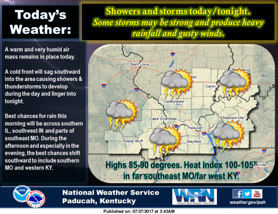
Over the next few hours, we will receive moderate to heavy rainfall, with a few rumbles of thunder, across Southern Illinois.  The large area of showers extends into Northeast Missouri.

It is on my bucket list to download a radar program, with velocity on storms.  My estimate is the storms are moving at a good clip at 30-40 mph.

We are still under a marginal risk for severe weather.  This will mainly be determined if the sun will come out after this round of percipitation, to provide instability in the atmosphere.  It is possible this large area of precipitation that is coming through will take a lot of the convective energy with it.

I do not have any scientific evidence to prove this, but it is out of observation.  Storms have been moving northwest to southeast now for about a month.  There is a possibility that we might have an early fall.

With winds shifting to the NNE after the cold front passes in the next 24 hours, they will blow the humidity out of here for the weekend.  With highs in the low 80’s, the air will have a fall feel to it.

Temperatures will moderate into the mid to upper 80’s by mid week.  There is not a 90 degree day in sight.  Enjoy it, and give your air conditioner a break, as window opening weather is on the way.

Below, is the Hazardous Weather Outlook and the Seven Day Forecast.

Hazardous Weather Outlook
National Weather Service Paducah KY
335 AM CDT Thu Jul 27 2017

This Hazardous Weather Outlook is for portions of southern
Illinois, southwest Indiana, western Kentucky, and southeast
Missouri.

.DAY ONE…Today and Tonight

Scattered to numerous thunderstorms will move across the northern
parts of the region today and across all of the area by this
afternoon or evening. A few severe thunderstorms with damaging
wind gusts are possible. Locally heavy rain is expected.

Across southeast Missouri and southern parts of western Kentucky,
heat indices may reach 100 to 105 degrees before the storms
arrive.

.DAYS TWO THROUGH SEVEN…Friday through Wednesday

A chance of thunderstorms will continue Friday morning across all
of the area and across mainly western Kentucky Friday afternoon.

.SPOTTER INFORMATION STATEMENT…

Spotter activation may be requested this afternoon and tonight for
reports of severe weather including heavy rain and flooding.

Detailed Forecast

Thursday
Showers and thunderstorms likely, mainly after 11am. Cloudy, with a high near 86. Southwest wind 3 to 8 mph. Chance of precipitation is 70%.
Thursday Night
Showers and thunderstorms likely, mainly before 10pm. Mostly cloudy, with a low around 71. West southwest wind around 6 mph becoming calm. Chance of precipitation is 60%.
Friday
A 20 percent chance of showers and thunderstorms before 1pm. Partly sunny, with a high near 85. North wind 5 to 11 mph.
Friday Night
Mostly clear, with a low around 63. North northeast wind 5 to 8 mph.
Saturday
Sunny, with a high near 81. North northeast wind 6 to 10 mph.
Saturday Night
Clear, with a low around 58. North northeast wind 3 to 7 mph.
Sunday
Sunny, with a high near 83. Northeast wind 3 to 6 mph.
Sunday Night
Mostly clear, with a low around 61. Northeast wind 3 to 6 mph.
Monday
Sunny, with a high near 85. Northeast wind 3 to 6 mph.
Monday Night
Mostly clear, with a low around 63. East northeast wind 3 to 6 mph.
Tuesday
Sunny, with a high near 88. East wind 3 to 5 mph.
Tuesday Night
Partly cloudy, with a low around 65. East northeast wind around 5 mph becoming calm in the evening.
Wednesday
Mostly sunny, with a high near 88. Light and variable wind.

Updated Hazarous Weather Outlook

Stormy Thursday….After front passes early Friday Morning, an awesome weekend on Tap

By Steve Dunford

The Storm Prediction Center has placed Southern Illinois in a marginal risk (level 1 of 5) risk of severe weather for tonight.  The good news is they have downgraded us from a slight risk to a marginal for tomorrow at this time.

Friday through Sunday will be a gorgeous day to be out in Southern Illinois.  Highs should be in the low 80’s with the low at night around 60.

The updated hazardous Weather Outlook and forecast is below.

Hazardous Weather Outlook
National Weather Service Paducah KY
426 PM CDT Wed Jul 26 2017

.DAY ONE…Tonight

A Heat Advisory remains in effect until 8 PM for southeast
Missouri, most of southern Illinois, and western Kentucky except
the Pennyrile region. Heat indices will remain around 105 degrees
away from thunderstorm activity.

There is a chance of thunderstorms tonight, mainly along and north
of a line from Carbondale to Owensboro. The main hazards will be
locally heavy rain and gusty winds up to 40 mph.

.DAYS TWO THROUGH SEVEN…Thursday through Tuesday

Thunderstorms are likely Thursday and Thursday night as a strong
cold front moves across our region. A few severe thunderstorms
with damaging wind gusts are possible. Locally heavy rain is
expected.

Across southeast Missouri and southern parts of west Kentucky,
heat indices may reach 100 to 105 degrees before the storms
arrive Thursday.

.SPOTTER INFORMATION STATEMENT…

Spotter activation may be requested Thursday afternoon and night.

This Afternoon
Scattered showers and thunderstorms. Mostly sunny, with a high near 94. South southwest wind around 7 mph. Chance of precipitation is 30%.
Tonight
A 30 percent chance of showers and thunderstorms, mainly after 2am. Mostly cloudy, with a low around 75. South wind 5 to 7 mph.
Thursday
Showers and thunderstorms likely, mainly after noon. Some of the storms could produce heavy rainfall. Cloudy, with a high near 87. Southwest wind 5 to 7 mph. Chance of precipitation is 60%.
Thursday Night
Showers and thunderstorms likely, mainly before 2am. Some of the storms could produce heavy rainfall. Mostly cloudy, with a low around 71. West southwest wind around 6 mph becoming calm. Chance of precipitation is 60%.
Friday
A 30 percent chance of showers and thunderstorms before 8am. Some of the storms could produce heavy rainfall. Partly sunny, with a high near 85. North wind 5 to 9 mph.
Friday Night
Mostly clear, with a low around 64. North northeast wind 6 to 9 mph.
Saturday
Sunny, with a high near 82. North northeast wind 6 to 9 mph.
Saturday Night
Clear, with a low around 60. Northeast wind 3 to 8 mph.
Sunday
Sunny, with a high near 83. Northeast wind 3 to 6 mph.
Sunday Night
Mostly clear, with a low around 61. Northeast wind 3 to 6 mph.
Monday
Sunny, with a high near 85. Northeast wind 3 to 5 mph.
Monday Night
Mostly clear, with a low around 65. East northeast wind around 5 mph becoming calm in the evening.
Tuesday
Sunny, with a high near 88. Light and variable wind.
Tuesday Night
Partly cloudy, with a low around 66. East northeast wind around 5 mph becoming calm in the evening.
Wednesday
A slight chance of showers and thunderstorms. Mostly sunny, with a high near 88. Light and variable wind

Trump Says Transgender People Will Not Be Allowed in the Military

WASHINGTON, DC – (Julie Hirshfield Davis, and Helene Cooper, New York Times.  Please click on the link above for the full story.  Here is an excerpt below.)

President Trump arriving with the first lady, Melania Trump, in Vienna, Ohio, for his rally on Tuesday.
Credit
Doug Mills/The New York Times

President Trump announced on Wednesday that the United States will no longer “accept or allow” transgender people in the United States military, saying American forces “must be focused on decisive and overwhelming victory” and could not afford to accommodate them.

Mr. Trump made the surprise declaration in a series of posts on Twitter, saying he had come to the decision after talking to generals and military experts, whom he did not name.

Here are the tweets below:

After consultation with my Generals and military experts, please be advised that the United States Government will not accept or allow……….Transgender individuals to serve in any capacity in the U.S. Military. Our military must be focused on decisive and overwhelming………victory and cannot be burdened with the tremendous medical costs and disruption that transgender in the military would entail. Thank you


Miners Announce Return Of Winter Wonderland

From the Southern Illinois Miners

MARION, IL – The Southern Illinois Miners are proud to announce that Winter Wonderland will return this coming December to Rent One Park.

Winter Wonderland will run from Thursday, December 7th through Monday, December 11th, 2017 and will include a spectacular fireworks show on Friday, December 8th. In addition, new this season will be opportunities for school groups to attend during the day. There will also be the chance for private companies to book events during Winter Wonderland on Thursday, December 7th and Monday, December 11th

More details on the schedule of activities during Winter Wonderland will come later via the team’s Facebook page and website. For more information, contact the Miners’ box office at (618) 998-8499.

Sentencing for Saline Co., IL doctor convicted of plotting to kidnap State’s Attorney postponed

http://www.kfvs12.com/story/35415690/sentencing-for-saline-co-il-doctor-convicted-of-plotting-to-kidnap-states-attorney-postponed

HARRISBURG, IL – (Brittany Jacob and Alicia Dobrinick, KFVS-TV.  Please click on the link above for the full story.  Here is an excerpt below.)

The sentencing for a Saline County doctor convicted of trying to have the state’s attorney kidnapped has been rescheduled.

from the Saline County Sheriff’s office

Brian Burns was scheduled to be sentenced on July 25, but he has requested new counsel. His new sentencing date is Aug. 29.

It took a Saline County jury less than two hours to convict Burns on felony charges of solicitation of aggravated kidnapping, conspiracy to commit aggravated kidnapping and attempted aggravated kidnapping. That trial took place in May 2017.

West City Approves Random Drug Screening for Village Employees

http://www.bentongazette.com/news/west-city-approves-random-drug-screening-for-village-employees/article_6f3c1878-6cd7-11e7-9e6e-8f732b18a7ae.html

WEST CITY, IL  – (William McPherson, Benton Gazette.  Please click on the link above for the full story.  Here is an excerpt below.)

The Village of West City has approved amendments to an ordinance to allow for random drug testing of village staff.

West City Attorney Ronald Giacone says the program will cover three separate types of drug testing. Those types include standard pre-employment drug tests, reasonable cause tests, and randomized drug tests.

According to Giacone, reasonable cause testing would be enacted in cases where the safety of a city employee was concerned, or where there would have been prior incidents which led to reasonable suspicion of drug use from supervisors or village officials.

Benton, West Frankfort, Illinois News | Franklin County News