Showers and thunderstorms this afternoon…forecasted to be after the eclipse

by Steve Dunford

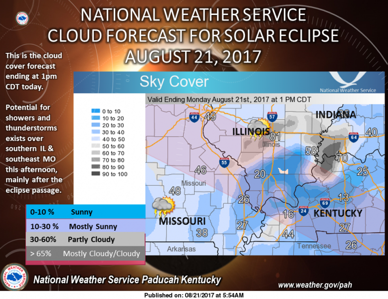
Here is a “snapshot” of the expected sky cover ending at 1 pm CDT today, beginning with the onset of the passage of the Solar Eclipse through the Quad State region. Persons at most locations should be able to see the eclipse during that time. However, there will be an increasing potential for afternoon showers and thunderstorms over southern Illinois and southeast Missouri, shortly after the passage of the solar eclipse through the area. If you are outdoors during and after the solar eclipse, have a plan to find shelter should showers and thunderstorms develop in your area. Cloud cover may change rapidly from moment to moment across the area today, so stay tuned!!! (NWS Paducah)

There is a chance of showers and thunderstorms this afternoon.  The rain chances for Carbondale is 80%.  For eclipse viewing, it seems Johnson County will be the prime spot for Southern Illinois.  Here in Franklin County, the further you go east the better.  According to the forecast, the Thompsonville area would be better than the west side.

For those in Carbondale I could see some repositioning to the Goreville and Vienna areas.  This might cause some additional traffic on Route 13, Interstates 57 and 24.

I will be monitoring the situation closely this morning.

The boundaries for the slight risk of severe weather tomorrow is areas from Route 45 east.  All of Southern Illinois is under a marginal risk.

Please stay hydrated if you are outside today. It will be another hot one.  The heat index will be between 100-105 again.

The eclipse will be a once in a lifetime experience.  Enjoy the show.

Below is a special weather statement from the national weather service, hazardous weather outlook and seven day forecast.

Special Weather Statement

…Heat Index Values 100 to 105 expected this afternoon over part
of the Quad State region…

Hot and humid conditions will be the rule today, regardless of the
passage of the solar eclipse through the region this afternoon, as
air temperatures top out in the lower 90s.

Heat index readings are expected to reach 100 degrees by noon over
Southeast Missouri. As temperatures rise into the lower 90s, heat
index readings above 100 degrees will build northeast across
southern Illinois and the Purchase area of West Kentucky, west of
the Land between the Lakes. Heat index values at or above 100
degrees will likely persist through 6 pm CDT today.

The rest of the Quad State region will see heat index values top
out in the upper 90s this afternoon.

If you are planning to be outside today for an extended period of
time, be sure to keep hydrated by drinking plenty of water. Look
for opportunities to get out of the heat from time to time, and
into the shade or in an air conditioned building.

Keep watch on those with you that may be susceptible to or
unaccustomed to the heat and humidity, typical for late August in
this region.

Hazardous Weather Outlook

.DAY ONE…Today and Tonight

Heat index values between 100 and 105 degrees will be possible
across southeast Missouri, Southern Illinois, and the Purchase
area of West Kentucky between Noon and 6 pm CDT.

Scattered thunderstorms are expected to develop near the I-64
corridor in southern Illinois and southwest Indiana, as well as
the foothills of southeast Missouri around 1 pm and work southward
into west Kentucky during the early evening. Another round of
thunderstorms are expected after midnight near the I-64 corridor.

Some of the thunderstorms in southern Illinois and southeast
Missouri may produce isolated wind gusts between 40 to 55 mph
during the afternoon. Locally heavy rain and lightning will also
be a hazard with these thunderstorms.

.DAYS TWO THROUGH SEVEN…Tuesday through Sunday

The Storm Prediction Center continues outlook a Marginal to
Slight Risk of Severe Thunderstorms for the entire area for
Tuesday and Tuesday night. The Slight risk of Severe Thunderstorms
stretches east of a line from Benton Illinois and Benton
Kentucky, and includes all of southwest Indiana, most of the
Pennyrile region of west Kentucky, and part of southeast
Illinois.

Damaging wind and Hail will be the primary hazards Tuesday
afternoon and evening. Locally heavy rain, capable of producing
isolated flooding, may be possible during the evening.

.SPOTTER INFORMATION STATEMENT…

Skywarn spotter activation may be requested for Tuesday and
Tuesday night.

Seven day forecast

Today
Showers and thunderstorms likely, mainly between 3pm and 4pm. Increasing clouds, with a high near 91. Calm wind becoming south 5 to 9 mph in the morning. Chance of precipitation is 60%.
Tonight
Scattered showers and thunderstorms before 7pm. Cloudy during the early evening, then gradual clearing, with a low around 73. South wind 5 to 7 mph. Chance of precipitation is 30%.
Tuesday
Scattered showers and thunderstorms, mainly between 10am and 4pm. Mostly cloudy, with a high near 85. South southwest wind 6 to 8 mph becoming west in the afternoon. Chance of precipitation is 50%.
Tuesday Night
Isolated showers and thunderstorms before 10pm. Mostly cloudy, with a low around 63. West northwest wind around 6 mph becoming light and variable. Chance of precipitation is 20%.
Wednesday
Sunny, with a high near 80. North northeast wind 5 to 8 mph.
Wednesday Night
Mostly clear, with a low around 58. North northeast wind 3 to 5 mph.
Thursday
Sunny, with a high near 79. Northeast wind 3 to 6 mph.
Thursday Night
Mostly clear, with a low around 57. Northeast wind around 6 mph.
Friday
Sunny, with a high near 80. East northeast wind 5 to 7 mph.
Friday Night
Partly cloudy, with a low around 59. East northeast wind around 5 mph.
Saturday
Mostly sunny, with a high near 81. East northeast wind around 6 mph.
Saturday Night
Partly cloudy, with a low around 61. East northeast wind 3 to 5 mph.
Sunday
Mostly sunny, with a high near 83. East wind 3 to 5 mph.


Comedy King Jerry Lewis Has Died at 91, His Agent Confirms

Comedy King Jerry Lewis Has Died at 91, His Agent Confirms

Paramount Pictures photo

LAS VEGAS, NV –  (Alexis Loinaz and Char Adams, People Magazine.  Please click on the link for the full story.  Here is an excerpt below.)

Comedy king Jerry Lewis, whose manic style amused generations of moviegoers on both sides of the Atlantic, yet whose popularity often confounded critics, has died, his agent confirmed to PEOPLE. He was 91.

Las Vegas Review Journal columnist John Katsilometes confirmed the news on Twitter on Sunday, writing that Lewis’ rep told him in a statement that he died at 9:15 a.m. on Sunday morning in his home in Las Vegas

In June, the actor was hospitalized in Las Vegas after developing a urinary tract infection, the latest in a history of health issues. In June 2006, Lewis suffered a mild heart attack in San Diego. Still, his manager told PEOPLE at the time, “He’s doing very well. He’ll be standing on that stage at the [Jerry Lewis Muscular Dystrophy Association] telethon on Labor Day.” In its time, the annual fundraiser, which Lewis started in 1966 (he stopped hosting as of 2010), is said to have raised more than $2 billion for medical research

RLC Day Tours focus on two St. Louis neighborhoods

by ReAnne Palmer

Experience two popular neighborhoods in St. Louis like never before with two Day Tours through Rend Lake College’s Community and Corporate Education Division. In October, visit the historic Victorian streets in Lafayette Square, and in November, learn about St. Louis’ Italian heritage at The Hill.

The Downton Abbey in Downtown St. Louis tour will make stops in Lafayette Square neighborhood and at the Campbell House Museum to take participants back to the opulence of the 1880s. After a five-year, $3 million restoration at the Campbell House Museum, participants will tour one of the most accurately restored 19th century buildings in America.
Lunch will be served at Mary Ann’s Tea Room before stopping by Lafayette Square to see the rows of Victorian homes, often referred to as the “painted ladies.” A tour of a private home and a horse-drawn carriage ride through Lafayette Square Park are included in the tour price of $145. Charter bus transportation, lunch and gratuities are also included.

Attendees will depart from the Ina campus at 7:30 a.m. Monday, Oct. 2 and will return that evening at 6:30 p.m. Participants can also board the bus at the Mt. Vernon MarketPlace at 8 a.m., with a return time of 6 p.m. All attendees must pre-register by Wednesday, Sept. 6.
The following month, visit famed Italian neighborhood The Hill during the Shop n Sample St. Louis tour. Stops on this tour include Chris’ Pancakes, J Viviano & Sons Grocer, and a tour at the Herbia Soap Factory. Lunch will be served at Favazza’s Restaurant on The Hill. The afternoon will be spent exploring St. Louis’ newest chic place to shop: IKEA.

Lunch, tour fees, gratuity, and charter bus transportation are included in the $120 fee. Participants can get on the bus in Ina or Mt. Vernon, at 7:30 a.m. and 8 a.m. respectively, on Tuesday, Nov. 21. The bus will return to Mt. Vernon by 6 p.m. and to Ina by 6:30 p.m. Attendees must pre-register by Sunday, Oct. 29.

To learn more about these Day Tours or to pre-register, contact RLC’s Community and Corporate Education Division at 618-437-5321, Ext. 1714 or commcorped@rlc.edu.


Veterans Airport: Eclipse Weekend to be ‘the busiest we have ever seen’

http://www.dailyrepublicannews.com/news/20170818/veterans-airport-eclipse-weekend-to-be-the-busiest-we-have-ever-seen

MARION, IL (John Homan, Marion Republican.  Please click on the link for the full story.  Here is an excerpt below.)

Motorists making their way past Veterans Airport of Southern Illinois this weekend and Monday may see a plethora of planes of various colors and sizes parked on taxiways, grassy fields and even the east/west runway, says airport manager Doug Kimmel.

“This (eclipse weekend) will undoubtedly be the busiest weekend and Monday in terms of number of aircraft here at the airport we have ever seen,” he said. “I wouldn’t be surprised to see up to 200 aircraft here – from small single-engine planes that seat a couple to larger corporate jets that may seat up to 20.”

Kimmel said Midwest Aviation is coordinating the housing of planes at the airport. He said the airport doesn’t stand to benefit all that much financially.

Stay well hydrated today and tomorrow…storms Tuesday….awesome weather at kickoff Friday

by Steve Dunford

Here is the expected sky cover at 1 pm CDT, during the passage of the Solar Eclipse across the Quad State region on Monday, August 21st. As we approach eclipse day, the accuracy and confidence of this forecast will improve. Stay tuned! (NWS Paducah)


It has been a while since I have commented on a forecast.   With the stretch of mild weather it has not been necessary.  The heat index today and tomorrow will be between 100-103 degrees.  This is just below the criteria of a heat advisory being issued, which is between 105-109 degrees.  Anything over 110, an excessive heat warning is issued.

Tuesday, there is a chance of storms with an approaching cold front.  Most of Southern Illinois is under a marginal risk of severe weather (level 1 of 5)  Points east of Route 45 is under a slight risk (level 2 of 5).

The weather played havoc with a lot of high school football games last fall.  There is a picture perfect forecast for week 1.  The high on Friday will be around 80 with the low around 60.

Below is the special weather statement from the National Weather Service in Paducah regarding the heat, the Hazardous Weather outlook and the seven day forecast.

Special Weather Statement

…Afternoon heat index values around 100 degrees expected this
afternoon and Monday afternoon…

For travelers and residents alike, hot and humid conditions will
be the rule for the afternoon hours this Sunday and Monday.

All of the Quad State region, including southern Illinois,
southwest Indiana, west Kentucky, and southeast Missouri will see
heat index values in the middle and upper 90s each afternoon.

For those of you living in southeast Missouri and southern
Illinois, heat index values could range between 100 and 103
degrees by the middle of the afternoon on both days.

If you are planning to view the solar eclipse or participate in
other outdoor activities, then please bring along plenty of water
to keep hydrated. If you have any opportunity to do so, take
breaks in the shade or in an air conditioned building.

Isolated thunderstorms will be possible today and on Monday over
parts of the region. Unfortunately, any rain or cloud cover will
do little to lessen the heat and humidity.

Storms will move through the region on Tuesday and will eventually bring
cooler temperatures to the Quad State region during the latter
half of this week.

Hazardous Weather Outlook

.DAY ONE…Today and Tonight

Isolated to widely scattered thunderstorms are forecast for part
of the outlook area today. Any storms that develop should remain
below severe levels.

Heat index values will top out around 100 degrees mainly during
the afternoon hours across southeast Missouri and southern
Illinois.

.DAYS TWO THROUGH SEVEN…Monday through Saturday

Isolated afternoon thunderstorms are forecast for part of
southeast Missouri and southwest Illinois on Monday. These storms
should remain below severe limits.

Heat index values will top out again near 100 degrees mainly
during the afternoon hours on Monday across southeast Missouri
and southern Illinois.

Scattered to numerous thunderstorms are forecast Tuesday through
early Wednesday morning. These thunderstorms are expected to move
slowly southeast in a broken line through the outlook area. Some
of the storms will likely become severe late Tuesday afternoon and
evening, with damaging winds the primary hazard, followed by
isolated large hail. Heavy rain will be a greater hazard during
the evening hours.

The Storm Prediction Center has issued a Slight Risk of Severe
Thunderstorms for Tuesday and Tuesday night, extending from
Benton Illinois and the Land Between the Lakes northeast into
parts of southeast Illinois, southwest Indiana, and the Pennyrile
region of west Kentucky. A Marginal risk of severe thunderstorms
covers the remainder of the outlook area Tuesday and Tuesday
night.

.SPOTTER INFORMATION STATEMENT…

Skywarn spotter activation may be requested Tuesday afternoon and
evening.

Seven Day Forecast

Today
Sunny, with a high near 93. South wind 3 to 6 mph.
Tonight
Mostly clear, with a low around 71. South wind 3 to 5 mph.
Monday
Mostly sunny, with a high near 92. South southwest wind 5 to 8 mph.
Monday Night
Partly cloudy, with a low around 73. South wind around 5 mph.
Tuesday
Showers and thunderstorms likely, mainly between 1pm and 4pm. Mostly cloudy, with a high near 87. South southwest wind 6 to 9 mph becoming west in the afternoon. Chance of precipitation is 70%.
Tuesday Night
A 30 percent chance of showers and thunderstorms, mainly before 1am. Mostly cloudy, with a low around 65. West northwest wind around 6 mph becoming light and variable.
Wednesday
Sunny, with a high near 80. North wind 5 to 7 mph.
Wednesday Night
Mostly clear, with a low around 57. North wind 3 to 6 mph.
Thursday
Sunny, with a high near 79. North northeast wind 3 to 6 mph.
Thursday Night
Mostly clear, with a low around 55. Northeast wind 3 to 5 mph.
Friday
Sunny, with a high near 79. East northeast wind 3 to 6 mph.
Friday Night
Partly cloudy, with a low around 60. Northeast wind 3 to 5 mph.
Saturday
Mostly sunny, with a high near 80. East northeast wind around 6 mph.


Just a reminder …….All Franklin County schools are closed tomorrow

By Steve Dunford

Because of the eclipse, all Franklin County Schools will not be in session tomorrow.  This was a decision by each individual district.

West Frankfort and Thompsonville were the first two to close.  The rest of the districts followed suit in the next couple of weeks.  The decision by all was made in early July.

Safety was the biggest concern of school officials.  First, daylight will not be fully restored at dismissal time.  Second, it would be hard to adequately supervise each child with eclipse glasses.  Third, if traffic projections hold true, it would have been hard to navigate buses on state highways, especially State Routes 148 and 37.

If you will be around children tomorrow, please make this an educational experience.

A “mixed bag” of reports about eclipse traffic so far

by Steve Dunford

I-57 southbound between the Sesser and Benton exits yesterday afternoon. (Tanyah Eubanks photo)

During a lot of winter weather events, it seems that Southern Illinois sits on the line of receiving rain/snow/sleet.  Over the years WSIL-TV Chief Meteorologist Jim Rasor has used the term “mixed bag of precipitation”.  It seems like local businesses are reporting the same thing.

Leigh Caldwell, co-host of the WJPF morning news watch with Tom Miller, sent out a plea on social media to the locals.  She stated, there was no problem with traffic between Carterville and Carbondale.  She went to Carbondale twice during the day.  She said that local businesses were dead and requested that everyone in Southern Illinois get out and enjoy the local festivals.

River Radio, especially WJPF, has committed to give people that are residents of Southern Illinois and tourists up to the minute news coverage about the eclipse.

There have been reports of traffic tie-ups for days in the Pacific Northwest, trying to get a good viewing spot to see the eclipse. Accu-weather.com has the area rated as good in that region, with Southern Illinois and most of the Midwest rated as fair.  I am wondering if that resulted in less traffic.

There was an SUV that caught fire on Interstate 57, just north of the Johnston City exit around mid morning.  The above photo was taken yesterday afternoon on I-57 between the Sesser and Benton exits.

On the other side of the coin, there were reports of traffic and local business being busier than usual.  Mindy Vanfossan of Hometown T-Shirts and Graphics said they had a very busy day yesterday.  It was (and maybe still is) one of the few places with eclipse glasses still.

Jim Emberton, of the Zeigler Police department, stated the town had around a 50% increase in traffic yesterday, with a lot of out of state plates in the city.

WSIL-TV said that Mary Lou’s grill, which is on the north side of the strip in Carbondale, was very busy, after a summer that was slow.  If there are some tourists that read this, the food there is awesome, especially the biscuits and gravy in a nostalgic setting.

Channel 3 also had another report the campgrounds are filling up quickly.

Personally, I feel the biggest of traffic for Franklin County will be tomorrow afternoon after the eclipse, until around noon on Tuesday.  I will be monitoring the situation closely until then.


Twenty years after Illinois’ 0.08 DUI law enacted, alcohol-impaired crash fatalities down significantly

IDOT, ISP remind motorists to ‘Drive Sober or Get Pulled Over’

Press release from the Illinois Department of Transportation

SPRINGFIELD – The Illinois Department of Transportation and Illinois State Police joined members of Mothers Against Drunk Driving and the Alliance Against Intoxicated Motorists at the Illinois State Fair today to remind motorists of the importance of driving sober, 20 years after Illinois’ implementation of its 0.08 DUI legislation.

“Illinois’ 0.08 law is a vital part of the effort to end drunk driving on Illinois roads,” said Priscilla Tobias, IDOT’s director of program development. “Alcohol-impaired motor vehicle crash fatalities have declined significantly over the last two decades, but we are nowhere near making drunk driving a thing of the past. It continues to shatter hundreds of lives each year in Illinois, and that is simply unacceptable.”

The law lowering Illinois’ DUI threshold to a blood-alcohol concentration of 0.08 took effect July 2, 1997, when Illinois became the 15th state to enact such a law. Today, all 50 states, the District of Columbia and Puerto Rico have a legal limit of 0.08 or lower.

Since the 0.08 law was enacted, alcohol-impaired motor vehicle crash fatalities in Illinois have dropped by about 43 percent. In 1996, the year before the law took effect, 534 people died in crashes involving at least one driver who was at or above the 0.08 level. In 2015, just more than 300 people died in alcohol-impaired crashes in Illinois.

George and Marilyn Murphy of Jacksonville lost their 24-year-old daughter, Kellie Murphy Wheatley, to a drunk driver on July 4, 1984. The couple worked vigorously for the passage of Illinois’ 0.08 law and continue to partner with MADD to help others avoid the tragedy their family experienced.

“Illinois’ 0.08 law is one of the greatest lifesaving pieces of legislation to become law,” George Murphy said. “Today, more people decide against getting behind the wheel after drinking, which has prevented countless tragedies.”

As Labor Day approaches, state and local law enforcement will be reminding motorists of the importance to drive sober and ramping up enforcement efforts through a “Drive Sober or Get Pulled Over” campaign. Beginning Aug. 21 through Sept. 5, the traveling public can expect to see roadside safety checks throughout the state and increased patrols for impaired drivers and seat belt law offenders, all in an effort to reduce motor vehicle fatalities and injuries.

“This Labor Day is especially noteworthy because of the recent 20th anniversary of the 0.08 law. This law was enacted to reduce DUI-related traffic crashes and has saved many lives, but there is still more work to do,” said Illinois State Police Director Leo P. Schmitz. “Driving under the influence continues to be a significant cause of serious injury and fatal traffic crashes. During the upcoming holiday weekend, IDOT, ISP and other law enforcement agencies will work together to remove impaired drivers from Illinois roadways. If you drink and drive, you will be arrested. Drive Sober or Get Pulled Over.”

Some steps to avoid a tragic crash or an impaired driving arrest:

• Plan ahead. Designate a sober driver before going out and give that person your keys.
• If you are impaired, call a taxi, use a ride-sharing service or mass transit, or call a sober friend or family member to get you home safely.
• If you notice a friend or family member is impaired, take their keys and help arrange a safe ride home.
• Promptly report impaired drivers you see on the roadways to law enforcement by pulling over and dialing 911.
• Make sure everyone in your vehicle wears their seat belt. It is your best defense in the event of a crash.

“Drive Sober or Get Pulled Over” is supported with federal highway safety dollars, administered by IDOT and supported by the Illinois State Police and local law enforcement agencies throughout Illinois.

Visit drivesober.illinois.gov for more information.


Special equipment will capture close up images of eclipse

http://www.wsiltv.com/story/36170762/special-equipment-will-capture-close-up-images-of-eclipse

WSIL-Photo

CARBONDALE, IL – (Evie Allen, WSIL -TV.  Please click on the image for the full story.  Here is an excerpt below.)

A group astrophotographers have set up outside of SIU’s football arena to take pictures of the eclipse using special equipment.

Astrophotographer Stephen Pizzo keeps a close eye on the sun’s movement, getting ready for Monday

“We’ll have everything here set up. We’ll start tracking at 9:00,” says Pizzo.

His team will capture the four stages of contact before, during, and after the total solar eclipse.
“You’ll have the sun in the center frame, then you’ll have plenty of black around it so that when we get to totality, that extra frame space is so you can see the corona,” says Pizzo.

Inflatables, Big Truck Day highlight RLCF Children’s Center area at Warrior Fest

ReAnne Palmer – Rend Lake College Public Information

Parents and children lined up to climb into tractors and big trucks of all sizes during Warrior Fest in 2016. In addition to Big Truck Day, the RLC Foundation Children’s Center also plans to host free events and a silent auction this year.
(ReAnne Palmer / RLC Public Information)

INA, IL –Spend the afternoon playing, learning, and exploring Rend Lake College’s campus with the whole family in the children’s area of Warrior Fest and Preview Day. The activities, hosted by the RLC Foundation Children’s Center (RLCFCC), will be held from 9 a.m. – 2 p.m. Saturday, Oct. 7 on the Ina campus.

The RLCFCC will feature many free, popular items from past years, including a number of inflatables manned by RLC AmeriCorps students and Big Truck Day. At Big Truck Day, popular vehicles and equipment will return from years past, including tow trucks, dump trucks, fire trucks, police squad vehicles, ambulances, backhoes, combines, tractors, cement mixers, and much more.

Brooke May, RLCFCC Director, said Big Truck Day is always a highlight because it gives the children a chance to climb inside and play with out-of-the-ordinary vehicles, plus speak with the professionals who man them.

“It is important for the kids to get hands-on experience, because children learn through doing and seeing. When a child gets to touch the equipment, climb on it, and ask questions directly of the person who operates the equipment, it becomes a real, exciting experience,” said May. “Each child will remember climbing on a huge combine, rather than simply reading about one in a book.”

The children’s area also features several free events. RLC’s Project CHILD will offer car seat safety checks for parents and Dental Safari will be available for dental checks. A silent auction will line the hallways of the Academic Building to raise funds for updating security cameras at the RLCFCC.

Throughout the day, parents of students who attend or wish to attend the Children’s Center will also have a great chance to meet the center’s teachers and staff. A pre-registration sign up for potential students in the spring will also be available. The RLCF Children’s Center has been accredited by the National Association for the Education of Young Children for more than a decade.

For additional information about the children’s events or Big Truck Day, contact Brooke May at 618-437-5321, Ext. 1393 or mayb@rlc.edu.

Benton, West Frankfort, Illinois News | Franklin County News