No relief to the bitter cold temperatures in sight

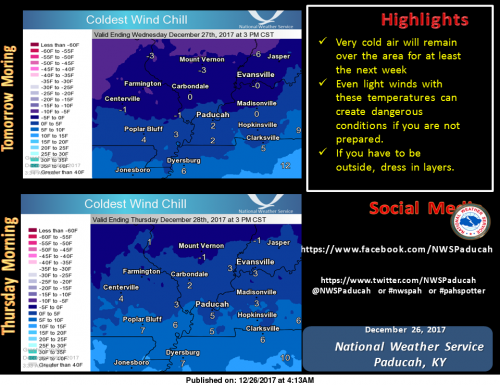
Temps below freezing for the entire forecast period

Today
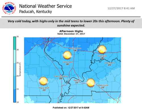
Sunny, with a high near 17. Wind chill values as low as -7. North wind 7 to 9 mph.
Tonight
Partly cloudy, with a low around 7. Wind chill values as low as -3. Northeast wind around 6 mph.
Thursday
Partly sunny, with a high near 26. Wind chill values as low as -2. East northeast wind around 6 mph becoming calm in the afternoon.
Thursday Night
Mostly cloudy, with a low around 17. Light and variable wind.
Friday
Mostly cloudy, with a high near 31. Light and variable wind becoming northwest around 5 mph.
Friday Night
Mostly cloudy, with a low around 15. North wind 3 to 7 mph.
Saturday
A 20 percent chance of snow after noon. Partly sunny, with a high near 20. North wind around 9 mph.
Saturday Night
Mostly cloudy, with a low around 6. North wind 7 to 9 mph.
Sunday
A slight chance of snow after noon. Mostly cloudy, with a high near 18. North wind around 7 mph.
Sunday Night
Mostly cloudy, with a low around 7. North wind around 7 mph.
New Year’s Day
Mostly sunny, with a high near 19. North wind 6 to 8 mph.
Monday Night
Partly cloudy, with a low around 6. North northwest wind 3 to 6 mph.
Tuesday
Mostly sunny, with a high near 24. North northwest wind around 6 mph becoming south in the afternoon.


Date set for first ‘Barack Obama Day’

SPRINGFIELD –  Aug. 4, 2018, will be the first time that Illinois will commemorate the date as Barack Obama Day.

Illinois’ General Assembly passed a law that would give Obama an official designation on his birthday. The supporters in Springfield originally wanted to make the day an official state holiday in which all non-vital state services would close.

This drew opposition from lawmakers such as state Rep. Mark Batinick, R-Plainfield, who thinks the state couldn’t afford to give state workers yet another paid holiday.

Please click on the link below from Illinois News Network

https://www.ilnews.org/news/state_politics/date-set-for-first-barack-obama-day/article_3074e98c-e764-11e7-a54d-0bf299975f23.html

Red Cross Blood Drive in Christopher today

CHIRSTOPHER –  There is a blood drive today in Christopher from 2:00 p.m. to 6:00 p.m. at the Christopher Community Building.

The building is located just off of Route 148 behind the old Dollar General building.  The event is sponsored by the First Baptist Church of Christopher.

Perry County deputy found dead Sunday

JACKSON COUNTY — Authorities are investigating the death of a deputy from a neighboring county.

Deputies found 33-year-old Joshua Harsy dead at a home in rural Jackson County just before 3 a.m. on Sunday morning.

Harsy worked as a deputy for the Perry County Sheriff’s Office, but he was off duty at the time.

Please click on the link below for the full story from WSIL-TV.

http://www.wsiltv.com/story/37135677/perry-county-deputy-found-dead

Very cold week ahead, chance of flurries today, snow chances for the weekend

Wind chills the next two mornings will be very cold, generally in the single digits to just below zero. These can be very dangerous if you are not prepared. Dress in layers if you have to be outside. (NWS Paducah)

Hazardous Weather Outlook

.DAY ONE…Today and Tonight

A few flurries or snow showers this afternoon may produce some
very minor snow accumulations, generally just a dusting.

Very cold air even with light winds will produce wind chills
ranging from 5 below zero to 5 above very late tonight.

.DAYS TWO THROUGH SEVEN…Wednesday through Monday

Very cold air will remain over the region through the period. Wind
chills on New Years morning are expected to range from zero to 10
below zero.

.SPOTTER INFORMATION STATEMENT…

Spotter activation is not anticipated.

Seven Day Forecast

Today
A chance of flurries with a slight chance of snow before 1pm, then a slight chance of snow between 1pm and 5pm, then a chance of flurries after 5pm. Mostly cloudy, with a high near 24. North northeast wind around 8 mph. Chance of precipitation is 20%.
Tonight
A chance of flurries before midnight. Mostly cloudy, then gradually becoming mostly clear, with a low around 9. Wind chill values as low as -1. North wind around 8 mph.
Wednesday
Sunny, with a high near 19. Wind chill values as low as -2. North northeast wind 6 to 8 mph.
Wednesday Night
Partly cloudy, with a low around 10. Wind chill values as low as zero. Northeast wind around 6 mph.
Thursday
Partly sunny, with a high near 27. East northeast wind around 6 mph becoming calm in the afternoon.
Thursday Night
Mostly cloudy, with a low around 17. Calm wind becoming west northwest around 5 mph after midnight.
Friday
Partly sunny, with a high near 30. West northwest wind around 5 mph becoming light and variable in the afternoon.
Friday Night
Mostly cloudy, with a low around 16. North northeast wind 3 to 6 mph.
Saturday
A slight chance of snow after noon. Partly sunny, with a high near 23. North wind 6 to 8 mph.
Saturday Night
A chance of snow. Mostly cloudy, with a low around 9. North wind around 7 mph.
Sunday
A chance of snow. Partly sunny, with a high near 19. North wind around 7 mph.
Sunday Night
Mostly cloudy, with a low around 6. North northwest wind around 7 mph.
New Year’s Day
Mostly sunny, with a high near 18. North northwest wind around 8 mph.

Village of Royalton under a boil water order

ROYALTON – The village of Royalton has issued a boil water order.

As of December 25th at 3:45pm, South Main Street from South 4th Street to South 6th Street are all affected areas.

This order stands until further notice.

A chance for another dusting of snow this evening….several chances throughout the week

Special Weather Statement

..Light Dusting of Snowfall Christmas Night…

A light dusting of snowfall is forecast with spotty snow showers
Christmas night. A half inch or less is expected, but with it
falling in much colder temperatures, this could create a few slick
spots on roads and walkways.

Christmas night travelers are advised to slow down, allow
a little extra time to turn or stop, and use your low beam
headlights to increase your visibility to others.

Hazardous Weather Outlook

.DAYS TWO THROUGH SEVEN…Tuesday through Sunday

A chance of light snow or flurries is forecast across all or a
part of the area Tuesday, Thursday afternoon and evening, Friday
night, and late Saturday night into Sunday. However, the potential
for impactful accumulation remains low at this point.

Seven Day Forecast

Christmas Day
Mostly cloudy, with a high near 31. West wind 6 to 8 mph.
Tonight
A 30 percent chance of snow showers, mainly between 9pm and 3am. Cloudy, with a low around 21. South southwest wind around 5 mph becoming calm in the evening.
Tuesday
Mostly cloudy, with a high near 26. Light north northeast wind increasing to 5 to 9 mph in the morning.
Tuesday Night
Mostly cloudy, with a low around 9. Wind chill values as low as zero. North wind 7 to 9 mph.
Wednesday
Sunny, with a high near 20. North northeast wind 7 to 9 mph.
Wednesday Night
Partly cloudy, with a low around 11. Northeast wind 6 to 8 mph.
Thursday
Mostly cloudy, with a high near 28. East northeast wind around 6 mph becoming calm in the afternoon.
Thursday Night
Mostly cloudy, with a low around 18. Calm wind becoming northwest around 5 mph after midnight.
Friday
Partly sunny, with a high near 31. West northwest wind around 6 mph.
Friday Night
A slight chance of snow after midnight. Mostly cloudy, with a low around 15. Northwest wind 5 to 7 mph.
Saturday
A slight chance of snow. Partly sunny, with a high near 22. North wind around 7 mph.
Saturday Night
A chance of snow. Mostly cloudy, with a low around 12. North northeast wind around 7 mph.
Sunday
A chance of snow. Mostly cloudy, with a high near 23. North wind around 8 mph.

Erratic driver reported on the west side of Franklin County

Mugshot of the erratic driver and his sleigh taken by a drone, over Creek Nation Blacktop between Zeigler and Royalton. He should be making his way through the entire county soon.

The Franklin County Sheriffs Department, Central Dispatch in Christopher, and other law enforcement agencies, are taking a lot of calls, regarding an erratic driver.

The driver is described as a heavy set older gentleman, with white hair, and a long white beard.  He is also wearing a red suit.

The vehicle is a sleigh, pulled by eight tiny reindeer and led by a fawn with a shiny nose.   With the snow flurries that is flying throughout the county, that will help with his visibility.

He is a jolly man, and he has been reported, going rooftop to rooftop, sliding down the chimney with a full bag of toys.  He stays for a few minutes at each house.  The bag is empty handed, and he always goes back to his sleigh munching on a cookie.

While in the air he has been reported to be saying Ho Ho Ho Merry Christmas!!!!

The law enforcement agencies, stated the man is neither armed or dangerous.  He is spreading love and cheer to each house he visits.

The authorities stated for him to pay a visit, all boys and girls need to go to bed soon, if they aren’t  already.

There will be further developments to this story early in the morning.


Merry Christmas !!!!!!!!!!!!!!!!!

Unless there is urgent and pertinent information that needs to be passed on to the citizens of Franklin County, the page will be silent until Tuesday.

Each and everyone of you, have a Merry Christmas and remember the reason for the season.

Up to one inch of snow in the forecast today

Christmas Eve travelers should be prepared for a little precipitation today. In the north, especially along the Interstate 64 corridor, a light dusting upwards to an inch is possible, mainly on grassy surfaces. Further south, the snow mixes with rain and little impact is expected. Air and ground temperatures will be above freezing this afternoon, but holiday travel caution is still advised in case untreated or elevated road surfaces present a slick patch or two. (NWS Paducah) 

The National Weather Service has issued a Special Weather Statement for up to one inch for the counties in Southern Illinois for Route 13 north.

If you plan on traveling today, there is a winter weather advisory out for the counties north of I -70.  Snow accumulations around 2″- 4″ is possible, with 3″ -5″ north of route 74.

I hope you all have a Merry Christmas and be careful if you are out and about. -sd


Benton, West Frankfort, Illinois News | Franklin County News