Maybe it’s time for the St. Louis Cardinals to move on from Kolten Wong
RLC Concealed Carry courses set for May 20-21 and August 4-5
by ReAnne Palmer – Rend Lake College Public Information
INA, Ill. (May 1, 2017) – Only two Illinois Concealed Carry courses remain this summer at Rend Lake College. A Saturday-Sunday course is set for May 20-21 and a Friday-Saturday session is scheduled for August 4-5.
Later this month, participants will prepare to apply for their permit from 8 a.m. – 4:30 p.m. both Saturday and Sunday. On day one, the firearms safety and marksmanship classroom portion of the course will focus on safety, principles of marksmanship, loading and unloading, cleaning, and state and federal laws relating to firearms and force. Firearms and ammunition are not to be brought to this class.
The second day will include interacting with law enforcement, recognizing risk factors and situational awareness, identifying threats, and learning about range rules and procedures. The live fire practice and qualification will also occur on the RLC Shooting Range. Students should bring their firearm with 100 rounds of unopened ammunition to be inspected by course instructors.
To qualify, students must complete 30 rounds at 5, 7, and 10 yards with at least 70 percent accuracy. A qualifying shot consists of a shot placed inside the 7 ring of a B-27 target.
In August, participants will meet from 4 – 10 p.m. Friday and 8 a.m. – 6:30 p.m. Saturday. All classes will meet instructors Ron Meek and Jeff Bullard in the Coal Mine Training Center, Room 107A, on the Ina campus.
Participants who complete RLC’s Concealed Carry training course are eligible to apply for Illinois and Florida Concealed Weapons licenses. A valid FOID card and a driver’s license must be brought to class. Students must attend the entire 16 hours of training, no exemptions will be given. Participants must be at least 21 years old. The cost of the training is $150 for in-state residents and $250 for out-of-state residents.
To learn more about these courses, call 618-437-5321, Ext. 1714. Pre-registration may be done in person, via phone call, or by emailing commcorped@rlc.edu.
Scott Burzynski named new HS Boys Basketball coach at Johnston City
The Johnston City school board hired Scott Burzynski as their new head HS boys basketball coach.
Burzynski. a 1992 gradate of Sesser-Valier, still holds the record for being the schools all time leading scorer. He went on to have a successful college career for Rich Herrin and the Southern Illinois Salukis.
He replaces Jerry Hampleman, who played for the Red Devils also in High School.
Burzynski has over 300 wins in his coaching career, guiding the Carterville Lions for seventeen years. He started his coaching career at Elverado.
There is some talent to work with, as the Indians have a loaded junior class. They should be in the thick of things in the Black Diamond East for the 2017-18 season.
sd
Updated road closure list -6:00 p.m. 5/1/17
From Franklin County Emergency Management Agency
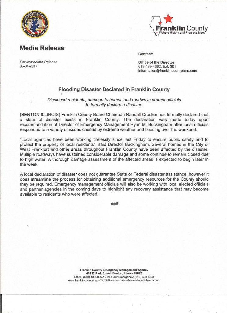
Flooding disaster declared in Franklin County
Media Release by Franklin County Emergency Management Agency Director, Ryan Buckingham
Bost Statement on Permanent Fix for Miner Health Benefit
Press release from Congressman Mike Bost’s office

Rep. Bost speaks on behalf retired miners outside US Capitol (Photo provided)
WASHINGTON – U.S. Representative Mike Bost (R-Murphysboro) issued the following statement following the announcement that a permanent fix for miner’s health care benefits was included in the upcoming Fiscal 2017 spending bill:
“My colleagues and I made it abundantly clear to congressional leadership in recent weeks that another short-term extension of these vitally important health benefits for coal miners would be simply unacceptable. These men and women worked hard in extremely dangerous situations to power America and were made a promise. I am pleased that we have reached a long-term fix on the health care piece. This gives us operating room to continue working on a solution for pensions.”
Governor Rauner Activates State Emergency Operations Center in Springfield
Press release from Governor Bruce Rauner’s office
SPRINGFIELD – Governor Rauner this morning activated the State Emergency Operations Center (SEOC) in Springfield to ensure state personnel and equipment are ready to be quickly deployed if needed to help local emergency responders with flooding-related public safety issues in several areas of the state.
“Several inches of rain has caused our rivers to swell, which has caused flooding in some communities. In order to expedite any state assistance to protect residents and critical infrastructure, I activated the State Emergency Operations Center with personnel from several key agencies to quickly react to any requests,” said Governor Rauner.
Representatives from the Illinois Emergency Management Agency (IEMA), Illinois State Police (ISP), the Illinois Department of Natural Resources (IDNR), Illinois Department of Corrections (IDOC), Illinois Department of Transportation (IDOT), Illinois Department of Public Health, the U.S. Army Corps of Engineers and the American Red Cross (ARC) have reported to the SEOC to coordinate deployment of state resources and personnel to assist communities preparing for or already battling floodwaters.
State resources already deployed include inmate crews from IDOC to assist with sandbagging in Murphysboro and Desoto; delivery of sandbags and plastic to Dawson, Grand Tower and the Menard Correctional Center in Murphysboro by IDOT; traffic support from ISP. In addition, the ARC has a shelter in Marion with others on standby if needed.
The SEOC will remain activated as long as necessary.
Morthland college receives minor water damage…eclipses goal for their library.
by Steve Dunford
From this past weekends heavy rains, Morthland College received some damage to their campus this weekend. I spoke to Leigh Caldwell, who wears many hats for Morthland, and she said, “We have some water damage at Coleman Rhoads Hall, in the area that houses a handful of student services employees. They are being temporarily relocated. None of our classes are affected.”
This resulted in the postponement of the book sale at the school.
Here is some good news. The campus set a lofty goal for enhancing their library. The following statement was on their Facebook page:

Morthland college photo
If you hear Alpharetta chime 50 times on the morning of 5.1, don’t be alarmed; we’re just #forgingon. The Hall Snyder Library is officially at 50,082 books. Our campus goal of 50k by May has been reached!
We’ve got a bit of a problem, though. Our library stacks are quite literally in stacks on the floor! Help us finish raising the funds by the end of month fuve to build 15 more shelves.
Morthland College is a Chirstian based, non-denominational, liberal arts Chirstian college in West Frankfort. They offer a wide range of programs including athletics. Through their guilds, they have provided many jobs to the people of Franklin and surrounding counties.
Flood warning extended until 5:45 P.M. 1″-3″ more inches of rain midweek
by Steve Dunford
The Flood Warning for Franklin County has been extended until 5:45 this evening. The warning text will be included in the bottom of this post. There are several road closures in the county still. This has been posted on the website and the Facebook page.
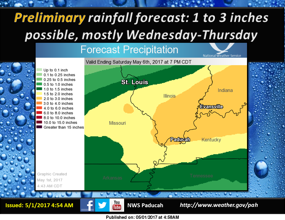
Starting Tuesday night into the overnight hours on Friday Morning there are chances of rain. During this period, it is forecast that we will receive an additional 1-3 inches of rainfall. (see graphic above)
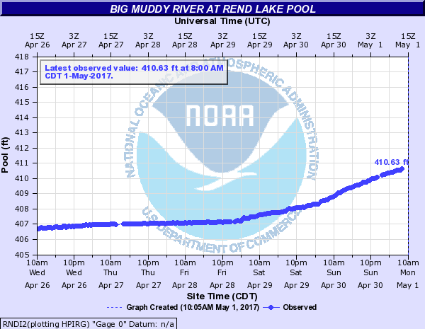
The water at Rend Lake is clearing the entire spillway, and not just the notch in the middle. (see graphic above) The water will do this at 410 feet. There is also a Lake Wind advisory for all of Southern Illinois. (advisory text below)
I will provide an update on facility closures. South Sandusky boat ramp is schedued to close sometime this evening.
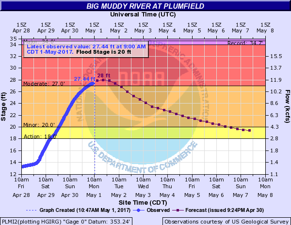
The Big Muddy at Plumfield is set to crest today at 28 feet in the moderate flood stage range. I spoke with Mary Lamm, Project Hydrologist at the National Weather Service in Paducah KY, and asked about the Big Muddy River and if the water released from Rend Lake will read on the automatic gauge there.
In our conversation she said that the gauge does compensate for it. She said that Rend Lake will affect the recession of the water that far down stream, but not add to the rise of it. River stage forecasts will include the additional rainfall projected starting tomorrow.
In some regional stages the Mississippi will crest in Chester at 43.5 feet on Thursday, which puts it in major flood stage. Several media outlets are sharing concern that the bridge will be closed there. There is only one lane open on the Missouri side. At Cape Girardeau the river will crest at 48.5 feet one-tenth above the record. It will also crest in Thebes on Saturday at 47 feet a few tenths below the record. All points on the Ohio, including Cairo are in moderate flood stage.
Here are the warnings and statements issued by the National Weather Service in Paducah KY.
FLOOD WARNING
The National Weather Service in Paducah has issued a * Flood Warning for… Perry County in south central Illinois… White County in southeastern Illinois… Wayne County in south central Illinois… Wabash County in southeastern Illinois… Jefferson County in south central Illinois… Edwards County in southeastern Illinois… Williamson County in southern Illinois… Saline County in southern Illinois… Jackson County in southern Illinois… Franklin County in south central Illinois… Hamilton County in south central Illinois… * Until 545 PM CDT Monday *
At 544 AM CDT, flooding continued in many areas. The threat for heavy rainfall is over. However, flooding along rivers, creeks and streams will continue, along with numerous water covered, flooded roads. There should be improvement in some areas. * Some locations that will experience flooding include… Carbondale, Marion, Mount Vernon, Herrin, Harrisburg, West Frankfort, Murphysboro, Mount Carmel, Benton, Du Quoin, Pinckneyville, Carterville, Carmi, Fairfield, Eldorado, Johnston City, McLeansboro, Christopher, Albion and Rend Lake Area.
PRECAUTIONARY/PREPAREDNESS ACTIONS… Turn around, don`t drown when encountering flooded roads. Most flood deaths occur in vehicles. Excessive runoff from heavy rainfall will cause flooding of small creeks and streams, country roads, farmland, and other low lying spots.
FLOOD WARNING FOR THE BIG MUDDY
…The flood warning continues for the following rivers in Illinois… Big Muddy River near Plumfield and Murphysboro .
The Big Muddy river at Plumfield is expected to crest this evening at 28.0 feet. It will start falling after that and should fall below flood stage on Saturday morning.
On the Big Muddy at Murphysboro… heavy rainfall…combined with backwater from the Misssissippi River… will continue to cause a rise this week. It will crest at 40 feet on Thursday…which puts us in the major flood category.
PRECAUTIONARY/PREPAREDNESS ACTIONS… SAFETY MESSAGE… Never drive cars…trucks or sport utility vehicles through flooded areas. The water may be too deep to allow safe passage. Never allow children to play in or near flood waters. Stay tuned to NOAA Weather Radio or your local media for further statements and possible updated forecasts.
HAZARDOUS WEATHER OUTLOOK
This Hazardous Weather Outlook is for portions of southern Illinois, southwest Indiana, western Kentucky, and southeast Missouri. .
DAY ONE…Today and Tonight Following the weekend heavy rainfall, flooding continues in parts of our region, mainly southeast Missouri and southern Illinois. Major to record flooding exists on smaller rivers in southeast Missouri and southern Illinois. Please check the latest flood statements and warnings for details. Gusty southwest winds from 15 to 25 mph are expected today, with gusts up to 35 mph this afternoon. A Lake Wind Advisory is in effect for today.
.DAYS TWO THROUGH SEVEN…Tuesday through Sunday River flooding will continue through next weekend. Some of the larger mainstream rivers such as the Mississippi River will rise throughout the week. Some of the smaller rivers will begin to recede Tuesday. Please check river flood statements. A chance of thunderstorms is forecast for all or a portion of the area Wednesday and Thursday. Lightning and locally heavy rainfall will be the primary concerns. Rainfall well over an inch from Wednesday through Thursday may aggravate existing flooding or lead to new flooding, especially over southern Illinois and southwest Indiana.
LAKE WIND ADVISORY
.Strong gusty southwest winds are expected today. These winds will be associated with the low pressure system that brought heavy rain and flooding to our region over the weekend.
The National Weather Service in Paducah has issued a Lake Wind Advisory, which is in effect from 7 AM this morning to 8 PM CDT this evening.
* TIMING…The strongest winds will occur from the late morning through the afternoon hours.
* WINDS…Southwest winds will increase to around 15 mph by mid- morning, then 20 to 25 mph for a few hours this afternoon. Gusts from 30 to 35 mph are likely this afternoon. Winds will decrease around sunset.
* IMPACTS…The strong gusty winds will pose a hazard to small boat operators on area lakes and rivers. Flood recovery efforts will also be negatively impacted, especially where boats are needed for checking flooded property.
PRECAUTIONARY/PREPAREDNESS ACTIONS… A Lake Wind Advisory indicates that winds will cause rough chop on area lakes. Small boats will be especially prone to capsizing.