Flood watch in effect for all of Southern Illinois until late Satruday night

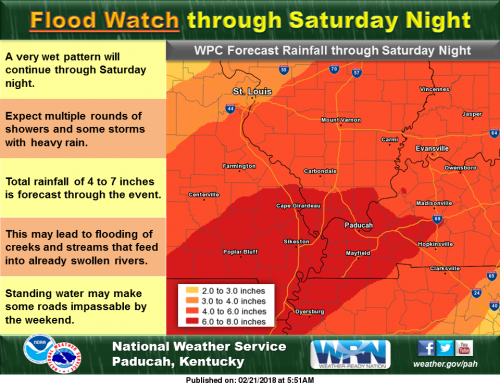
A Flood Watch is in effect through Saturday night. A very wet pattern will continue with multiple rounds of showers and some thunderstorms with heavy rain through the remainder of the week. Total rainfall of 4 to 7 inches is generally forecast through Saturday night. This may lead to flooding of creeks and streams that feed into already swollen rivers. Standing water may make some roads impassable by the weekend. Remember, if you encounter a water covered road, turn around and find an alternate route. (NWS Paducah)

..FLOOD WATCH NOW IN EFFECT THROUGH LATE SATURDAY NIGHT…

The Flood Watch is now in effect for

* All of southeast Missouri, southern Illinois, southwest Indiana
and western Kentucky.

* Through late Saturday night.

* Multiple rounds of rain, moderate to heavy at times will
increase the risk for areal flooding through the end of the
week, primarily from Thursday night through Saturday night.
Isolated low land and poor drainage areal flooding cannot be
ruled out before then.

* The main flooding concern will be along small streams and creeks
that feed into already swollen rivers across the region.
especially in areas that receive multiple rounds of moderate to
heavy rainfall. Elsewhere, elevated water levels in low lying
and poor drainage areas may lead to standing water across some
roads that typically flood.

PRECAUTIONARY/PREPAREDNESS ACTIONS…

A Flood Watch means there is a potential for flooding based on
current forecasts.

You should monitor later forecasts and be alert for possible
Flood Warnings. Those living in areas prone to flooding should be
prepared to take action should flooding develop.

Hazardous Weather Outlook

This Hazardous Weather Outlook is for portions of southern
Illinois, southwest Indiana, western Kentucky, and southeast
Missouri.

.DAY ONE…Today and Tonight

Rain will continue off and on today through tonight. The highest
rainfall totals today through tonight will be across west
Kentucky. Will monitor this area for isolated standing water
issues.

Temperatures will drop to near 32 degrees today from around Marble
Hill Missouri to Pinckneyville Illinois. This may result in some
light freezing rain mainly on elevated surfaces. Confidence is low
with respect to potential impacts on road surfaces. We will
monitor conditions through the day.

.DAYS TWO THROUGH SEVEN…Thursday through Tuesday

Multiple rounds of showers and thunderstorms will bring periods of
heavy rain to the entire region Thursday night through Saturday
night. The flooding concern will increase with each round of heavy
rainfall, culminating with the cold frontal passage Saturday night.
Please refer to the Flood Watch for more details.

The potential for strong thunderstorms late Saturday afternoon into
Saturday night will also need to be monitored closely. The greatest
limiting factor may be the availability of surface based instability
with the amount of cloud cover and rain forecast.

Continue to monitor the latest river flood warnings for impact
messaging and forecast stage information.

.SPOTTER INFORMATION STATEMENT…

We request spotters report rainfall totals along with any
observed area flooding over the next several days.

Seven Day Forecast

Today Rain. High near 38. North wind 10 to 13 mph, with gusts as high as 25 mph. Chance of precipitation is 90%.

Tonight Rain, mainly before 5am. Temperature rising to around 39 by 4am. Northeast wind around 11 mph, with gusts as high as 18 mph. Chance of precipitation is 100%.
Thursday A 20 percent chance of rain before noon. Cloudy, with a high near 50. Northeast wind 5 to 9 mph.
Thursday Night Showers likely, then showers and possibly a thunderstorm after midnight. Some of the storms could produce heavy rain. Low around 46. East northeast wind 5 to 7 mph becoming west southwest after midnight. Chance of precipitation is 100%.
Friday Showers and possibly a thunderstorm before noon, then a chance of showers. Some of the storms could produce heavy rain. High near 57. West northwest wind around 6 mph becoming north northeast in the afternoon. Chance of precipitation is 80%.
Friday Night Showers and possibly a thunderstorm. Some of the storms could produce heavy rain. Low around 50. Light and variable wind becoming east southeast 5 to 7 mph after midnight. Chance of precipitation is 90%.
Saturday Showers and possibly a thunderstorm. Some of the storms could produce heavy rain. High near 64. East southeast wind 7 to 13 mph becoming south in the afternoon. Chance of precipitation is 90%.
Saturday Night Showers and possibly a thunderstorm before midnight, then a chance of showers. Some of the storms could produce heavy rain. Mostly cloudy, with a low around 44. South wind 13 to 15 mph becoming west after midnight. Winds could gust as high as 25 mph.
Sunday Mostly sunny, with a high near 54. West wind 7 to 15 mph, with gusts as high as 24 mph.
Sunday Night Mostly clear, with a low around 36. Northwest wind 5 to 7 mph becoming east after midnight.
Monday Sunny, with a high near 56. East southeast wind 5 to 7 mph becoming north in the afternoon.
Monday Night Mostly clear, with a low around 37. East southeast wind 5 to 7 mph.
Tuesday Sunny, with a high near 57. East wind 6 to 8 mph becoming south southeast in the morning.

Franklin County Farm Bureau News

From Gay Bowlin –  Franklin County Farm Bureau Manager 

THIS IS NATIONAL FFA WEEK – Several events are planned in the schools this week and as always we are very proud of all of the FFA Chapters.

Scholarships Available to Franklin County Students for 2018

The Foundation Scholarship and the Young Leaders Scholarships are available to anyone attending a post secondary school to study in an agriculture related field. All applicants must be a resident of Illinois and must be a Franklin County Farm Bureau Member or dependent in good standing.

The Foundation and the Young Leaders will both award scholarships based on: Academic performance and honors, rank in class, ACT/SAT score, community involvement, demonstrating an interest in agriculture and/or agribusiness, character and personality, maturity, intellectual interest, moral character and demonstration of leadership skills.

Applications must be returned to the Franklin County Farm Bureau no later than April 5, 2018 to be eligible for consideration for the 2018 scholarships.

Applications are available now and can be picked up the at the Franklin County Farm Bureau Building at 1210 Highway 14 West in Benton send to you by email. Call the office at (618) 435-3616 if you have any questions.

Ag in the Classroom will be having a book drawing for all Franklin County Schools K-6. The book to be given is “The Popcorn Astronauts”. Teachers from each school will have the opportunity to fill out an entry form each day and put into a drawing box. Entry boxes will be picked up on March 1 and drawing will be March 2.

The books can then be taken to the Southern Illinois Reads Book Festival at DuQuoin High School where they will have the opportunity to get the book signed by the author. The Southern Illinois Reads Book Festival will take place on Saturday, March 10, 2018 and is open to the public. There will be activities during the day for so that everyone in attendance can get involved. There will be different authors for different levels of books.

Summer Ag Institute

Teachers Summer Ag Institute for Franklin, Jefferson and Hamilton Counties will be held on June 19-22 at Rend Lake College. PDCH (Professional Development Credit Hours) will be awarded to Teachers. If you are interest in attending this or would like more information call the office at 435-3616.

Franklin County Young Leaders Pork Loin Sale
JUST IN TIME FOR EASTER DINNER
FRANKLIN COUNTY FARM BUREAU YOUNG LEADERS
ARE TAKING ORDERS FOR SMOKED PORK LOIN.
READY FOR PICK-UP ON MARCH 28 & 29 –
½ LOIN – $35 FULL LOIN – $50
SEE A FCFB YOUNG LEADER OR CALL (618) 435-3616
(ALL PROFIT WILL BE USED FOR COUNTY SCHOLARSHIPS)

Remember we are farmers working together. If we can help let us know.

Benton Police make three recent arrests

BENTON – On February 16th, 2018 Benton Police conducted a traffic stop at the intersection of East Main and Stuyvesant Street. Through investigation, police arrested Christina L. Walden, age 39, of Benton for driving while license revoked. Walden was transported to the Franklin County Jail for further processing.

On February 17th, 2018 Benton Police arrested Dennis C. Donaldson, age 48, of Benton on an active Franklin county warrant for failure to appear. Donaldson was transported to the Franklin County Jail for further processing.

On February 19th, 2018 Benton Police conducted a traffic stop in the 800 block of Frisco Street.
Through investigation, police arrested Robert L. Plumlee, age 23, of Benton for driving while license revoked. Plumlee was charged and transported to the Franklin County Jail for further processing.

The public is reminded the alleged are presumed innocent until proven guilty by a court of law.

Wind advisory issued until 6:00 p.m.


The National Weather Service in Paducah has issued a Wind Advisory, which is in effect until 6 PM CST this evening for the following counties,  ALEXANDER … FRANKLIN … JACKSON … JEFFERSON … PERRY … UNION.

* TIMING…This afternoon.

* WINDS…South southwest winds will gust 40 to 50 mph.

* IMPACTS…Vehicular traffic, especially for high profile
vehicles, will be affected with rough driving conditions. Mobile
homes and outdoor construction work will be affected. Choppy
waves on area water bodies will make boating hazardous,
especially on Rend Lake.

PRECAUTIONARY/PREPAREDNESS ACTIONS…

A wind advisory is issued when sustained winds are expected to
reach 30 mph or greater for longer than one hour…or wind gusts
are expected to reach 40 mph for any duration.

Hazardous Weather Outlook

.DAY ONE…Today and Tonight

There is a chance of thunderstorms tonight, with heavy rainfall
possible, mainly after midnight.

South winds may gust around 35 mph or slightly higher today.

.DAYS TWO THROUGH SEVEN…Wednesday through Monday

The rains late Tuesday through Wednesday night will likely set the
stage for the possibility of areal flooding mid to late week, as
rounds of widespread showers and a few thunderstorms are expected,
producing multiple periods of heavy rainfall across the region
Thursday night through Saturday night. The flooding concern will
increase with each round of heavy rainfall, culminating with the
cold frontal passage Saturday night. A few strong storms cannot be
ruled out Saturday.

.SPOTTER INFORMATION STATEMENT…

Rainfall measurements from our spotters are requested, along with
any reports of observed flooding later in the week.

Hydrologic Outlook

The forecast weather pattern this week continues to support
multiple rain episodes, that will likely result in several inches of
rain. An initial round is expected from late tonight through
Wednesday night. Additional rains will come later in the week,
especially from Thursday night through Saturday night.

The main concern with this week`s rainfall will be the potential
for additional flooding of rivers and their tributaries. Flooding of
low land and poor drainage areas will become likely mid to late
week. We may see some flooding develop on roads that typically
experience water problems during longer duration heavy rain events,
again from mid to late week.

Stay tuned for later statements and updates.

Seven Day Outlook

This Afternoon
A 40 percent chance of showers, mainly after 4pm. Cloudy, with a high near 73. Breezy, with a south wind 16 to 21 mph, with gusts as high as 37 mph.
Tonight
Showers and possibly a thunderstorm. Some of the storms could produce heavy rainfall. Patchy fog after 10pm. Low around 37. South wind 13 to 16 mph becoming north northwest after midnight. Winds could gust as high as 26 mph. Chance of precipitation is 100%.
Wednesday
Showers. High near 39. North wind 10 to 13 mph, with gusts as high as 21 mph. Chance of precipitation is 100%.
Wednesday Night
Showers. Low around 37. Northeast wind 8 to 10 mph. Chance of precipitation is 80%.
Thursday
A 30 percent chance of showers, mainly before noon. Cloudy, with a high near 51. Northeast wind 5 to 8 mph.
Thursday Night
Showers likely, then showers and possibly a thunderstorm after midnight. Low around 48. East wind around 6 mph becoming south after midnight. Chance of precipitation is 80%.
Friday
Showers and possibly a thunderstorm before noon, then a chance of showers. High near 58. South southwest wind around 6 mph becoming north northeast in the afternoon. Chance of precipitation is 90%.
Friday Night
Showers likely, then showers and possibly a thunderstorm after midnight. Cloudy, with a low around 49. East wind 5 to 10 mph becoming south after midnight.
Saturday
Showers and possibly a thunderstorm. Cloudy, with a high near 62. South southwest wind 8 to 10 mph.
Saturday Night
Showers likely and possibly a thunderstorm before midnight, then a slight chance of showers. Mostly cloudy, with a low around 41. South southwest wind 9 to 14 mph becoming west after midnight. Winds could gust as high as 22 mph.
Sunday
Mostly sunny, with a high near 54. West northwest wind 6 to 14 mph, with gusts as high as 23 mph.
Sunday Night
Mostly clear, with a low around 36. West southwest wind around 6 mph becoming southeast after midnight.
Monday
Sunny, with a high near 57. South southeast wind 5 to 10 mph becoming west southwest in the afternoon.


Drug sweep at FCHS this morning

Press Release by Matt Donkin, District 168 Superintendent 

WEST FRANKFORT – As part of their regular services, the Illinois State Police, working with the West Frankfort Police Department, offer Drug dog sweeps as part their prevention programs.

These visits are unannounced to school officials as to better preserve their effectiveness. One of those surprise visits is happening this morning at FCHS.

This is part of our continued cooperative work to keep our kids and our schools safe. There is no threat that we are aware of today. We also hope to have a clean sweep and then go about our regular day.

Superintendent Donkin thanks  everyone in advance for their cooperation as we work through the tough and challenging issues that we are facing.

Makandastrong fundraiser

Makanda Williams -WSIL-TV photo

BENTON – On May 11th, 2017 Makanda Williams was diagnosed with diffuse intrinsic poline glioma, or DIPG, a rare malignant brain tumor found in children with no effective treatment in the U.S.

“In Mexico they’re using 8-10 different chemo therapy drugs that are all FDA approved. Every three to four weeks right now we travel, we’re gone three to four days at a time, without travel expenses, the treatment itself is 16-thousand dollars.” Carlton said.

Makanda’s mom plans to hold one of their biggest fundraisers on February 25th at the Benton Eagles. Dozens of local businesses have donated services and goods to the event.

Please click on the link for the full story from Taylor Vessel of WSIL-TV

http://www.wsiltv.com/story/37540950/makandastrong-fundraiser


Redbirds have huge second half, defeat Vienna 61-36

Redbirds advance to face Anna-Jonesboro tonight at 7:00 in the Johnston City Class 2A regional

JOHNSTON CITY – West Frankfort exploded for 43 points in the second half to come-from-behind and beat Vienna, 61-36, in the opening round of the Johnston City Class 2A boys basketball regional Monday night.

“We got on a run in the third quarter, and I was especially proud of my kids on how they were able to maintain the runs,” said West Frankfort Kevin Toney. “They would hit a shot, but we would get right back on the horse and rode it pretty hard.”

West Frankfort trailed by two at the half and was still down by two with 6:25 remaining in the third when C.J. Johnson sank back-to-back 3-pointers and it was off to the races for the Redbirds. Johnson and Kyle Hammers led the Redbirds with 15 points each.

Please click on the link for the full story from Geary Dentison of the Southern Illinoisan.

http://thesouthern.com/sports/west-frankfort-chester-advance-at-regional/article_4a02ca84-949d-55cc-bdbb-029764a1abc1.html

Imogene Lambert – Benton formerly of Christopher

Imogene Lambert, 93, passed away from this earth to heaven on February 18, 2018 at her home at Fifth Seasons Assisted Living.

She was born on January 19, 1925 in Valier to Ethel (Brayfield) Bradley and Earl G. Bradley. She met and married Charles M. Lambert, the love of her life for 73 years and he survives.

To this union two sons were born Alan Lambert (Deceased 1992) and Brad (Kathy) Lambert of St. Charles, MO. In addition to her son, she was preceded in death by her parents, three sisters, and one brother.

Other survivors are two grandsons Dylan (Autumn) Lambert of O’Fallon, MO and Ryan (Kate) Cavanaugh of Grayslake, IL and three great grandson Owen, Finn and Jack. One brother Bill (Rita) Bradley of Eufaula, OK and numerous nieces and nephews.

She was a graduate of Christopher High School and made a career as a clerk and checker for both Kroger and Sanitary market. She and Charles were active members of the Christopher First Baptist Church for 20 years before moving their memberships to Valier First Baptist Church where they still serve.

Services will be conducted by Brother Harl Ray Lewis and assisted by Pastor Kevin Bradley.  Visitation will be from 11:00 AM until 1:00 PM at the Gilbert Funeral Home in Christopher with the funeral at 1:00 PM.  Burial will be at a later date. In lieu of flowers memorials may be made to Hospice of Southern Illinois, 204 Halfway Road, Marion, IL 62959 or to the Valier First Baptist Church.

Randy Santor – Benton

Randy R. Santor, 52, of Benton IL passed away unexpectedly on Friday, February 16, 2018 at his residence in Illinois.

He was born in Plattsburgh on May 22, 1965, the son of Jerry and Connie (Wells) Santor.

Randy graduated from Peru Central School in 1983. After graduating from high school, he worked at Ames and O’Neill Packing before moving to Illinois. Once in Benton, he worked at McDonalds and Ricky Nix Garage for many years.

In his free time, Randy loved to hunt and fish. He also was always willing to help anyone who needed it with the biggest smile on his face. He was a very family oriented man. If Randy wasn’t on the phone chatting and laughing with his loving parents, he was spending time with his Aunt, Uncle, and cousins from Illinois. But most importantly, Randy was a devoted father to his sons, Adam and Joey. He cherished them deeply.

Left to cherish the memory of Randy, in addition to his parents, are his brothers, Terry Santor and his wife, Kathy, and Barry Santor and his fiancé, Franca Leto; his sons, Adam and Joseph (Joey) Santor; as well as the rest of the Santor family and friends who will miss him very much.

In lieu of flowers, donations in the memory of Randy R. Santor may be made to his sons, Adam and Joey Santor, to benefit their education.

Visitation will be from 5:00 P.M. to 7:00 P.M. on Wednesday, February 21st at the Morton & Johnston Funeral Home in Benton.

For more information,  please visit our website, https://www.mortonjohnstonfuneralhome.com/.

Wanda Treece -Formerly of Whittington

Wanda Mae (Beasley) Treece, age 93, passed away on her birthday February 15, 2018 at Tidewell Hospice House in Arcadia, Florida.  Wanda was born on February 15, 1925, in Whittington, IL to Alonzo Beasley and Evelyn (Clinton) Beasley.  Wanda graduated Benton High School and married the love of her life Jack Ronel Treece, son of Frank and Nora Treece.

Wanda was a retired beautician, who loved spending time with her family.

Wanda is survived by her daughter Judy Lynn (Treece) Jones and her beloved son in law David L. Jones; two grandchildren, Heather L. (Jones) Buntin and husband, Steve; Clinton l. Jones and wife, Jessica; great-granddaughter Megan L. Buntin.

Wanda was preceded in death by her husband Jack R. Treece and son Larry Jack Treece; her parents; two brothers, Bill Beasley and Donald Beasley.

Graveside services will be held at 11 a.m. Saturday, February 24, 2018 at Masonic and Oddfellows Cemetery in Benton, with Bryant Harris officiating.

The Morton & Johnston Funeral Home in Benton is in charge of arrangements.

For more information or to sign the online guest register please visit www.mortonjohnstonfuneralhome.com

Benton, West Frankfort, Illinois News | Franklin County News