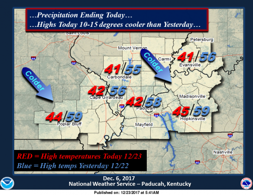
After a wet start to the day, look for precipitation to diminish and some folks may even see some sunshine during the afternoon. Cooler air will be settling in, however, with high temperatures some 10 to 15 degrees cooler than they were just 24 hours ago. (NWS Paducah)
Hazardous Weather Outlook
.DAY ONE…Today and Tonight
A flash flood watch remains in effect until 9 AM for our
Tennessee border counties in western Kentucky, from Murray,
eastward toward Hopkinsville. Refer to the Watch for details.
Rain may change to snow before ending today, mainly for our
northwest counties in southeast Missouri and southern Illinois.
Little accumulation is expected, and if any occurs, it will be
mainly on grassy and sheltered surfaces as air and ground
temperatures remain above freezing.
.DAYS TWO THROUGH SEVEN…Sunday through Friday
Rain may mix with or change to snow Sunday, mainly for our
northern counties, especially along and north of Interstate 64 in
southern Illinois and southwest Indiana. A light dusting is
possible there.
Light snow, mixed at times with light rain over southern portions of
the region, is possible Thursday into Friday. Potential snow
accumulation is quite uncertain at this point, but still looks to be
fairly low.
.SPOTTER INFORMATION STATEMENT…
Spotter reports of rainfall and any flooding are appreciated.
Seven Day Forecast


Speak Your Mind
You must be logged in to post a comment.