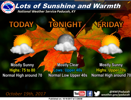
The warming mid October trend will continue for the remainder of the work week, as High pressure retains its strong grip across the Ohio and Tennessee river valleys. We see lots of sunshine today and tomorrow, as temperatures warm into the middle and upper 70s, even hitting 80 degrees in a few locations. Lows will be moderating through the 40s, back toward the 50s for the weekend start. Normal highs and lows for this time of year are around 70 and in the mid 40s. (NWS Paducah)
Hazardous Weather Outlook
.DAY ONE…Today and Tonight
No hazardous weather is expected.
.DAYS TWO THROUGH SEVEN…Friday through Wednesday
Saturday night into Sunday offers the next best chance of
thunderstorms, with locally heavy rain and lightning the primary
storm hazards anticipated.
Seven day forecast
Today
Sunny, with a high near 78. Calm wind becoming south southwest around 6 mph in the morning.
Tonight
Clear, with a low around 50. South wind 3 to 5 mph.
Friday
Sunny, with a high near 79. South wind 3 to 7 mph.
Friday Night
Partly cloudy, with a low around 55. South southeast wind around 6 mph.
Saturday
Partly sunny, with a high near 78. South wind 5 to 13 mph, with gusts as high as 18 mph.
Saturday Night
A slight chance of showers and thunderstorms, then showers likely and possibly a thunderstorm after 1am. Mostly cloudy, with a low around 62. South southeast wind 7 to 10 mph. Chance of precipitation is 70%.
Sunday
Showers and possibly a thunderstorm. High near 70. South wind 10 to 13 mph, with gusts as high as 24 mph. Chance of precipitation is 90%.
Sunday Night
A chance of showers and thunderstorms. Mostly cloudy, with a low around 52. North northwest wind 3 to 7 mph.
Monday
A chance of showers, with thunderstorms also possible after 1pm. Partly sunny, with a high near 67. Northwest wind around 6 mph.
Monday Night
Partly cloudy, with a low around 50. West wind 3 to 6 mph.
Tuesday
A slight chance of showers. Mostly sunny, with a high near 65. West northwest wind 7 to 14 mph, with gusts as high as 24 mph.
Tuesday Night
Mostly clear, with a low around 43. West northwest wind 6 to 8 mph.
Wednesday
Mostly sunny, with a high near 58. Northwest wind 6 to 8 mph.


Speak Your Mind
You must be logged in to post a comment.