More sunshine and less humidity are expected through mid week as high pressure takes hold of the region’s weather. Humidity will begin to creep higher by Thursday and Friday ahead of an approaching cold front. That will lead to our next chance of showers and thunderstorms, which may linger through the weekend in some locations. (NWS Paducah)
Detailed Forecast
weather.gov
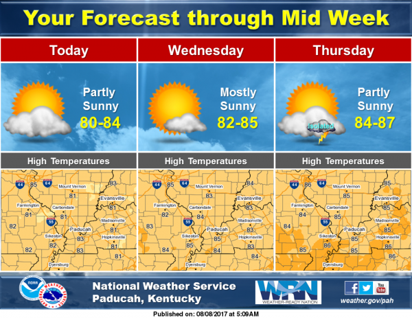
Today
Patchy fog before 8am. Otherwise, sunny, with a high near 80. Northeast wind around 7 mph.
Tonight
Mostly clear, with a low around 59. Northeast wind 3 to 6 mph.
Wednesday
Sunny, with a high near 83. East wind 3 to 6 mph.
Wednesday Night
Partly cloudy, with a low around 63. East northeast wind around 5 mph becoming calm in the evening.
Thursday
Partly sunny, with a high near 85. Light and variable wind.
Thursday Night
A 20 percent chance of showers and thunderstorms after 1am. Mostly cloudy, with a low around 67. Light southeast wind.
Friday
A 20 percent chance of showers and thunderstorms. Mostly sunny, with a high near 85. Calm wind becoming west around 5 mph in the afternoon.
Friday Night
A slight chance of showers and thunderstorms. Partly cloudy, with a low around 66. West wind around 5 mph becoming calm in the evening.
Saturday
Partly sunny, with a high near 84. Light north wind.
Saturday Night
A chance of showers and thunderstorms, mainly after 1am. Mostly cloudy, with a low around 66. Light northeast wind.
Sunday
A slight chance of showers and thunderstorms. Mostly cloudy, with a high near 82. North wind 3 to 6 mph.
Sunday Night
Partly cloudy, with a low around 64. North wind 3 to 6 mph.
Monday
Mostly sunny, with a high near 82. North wind 3 to 6 mph.


Speak Your Mind
You must be logged in to post a comment.