 The Storm Prediction Center has issued a Severe Thunderstorm Watch until 5am for all counties in Southern Illinois with the exception of Randolph, Perry and Massac. Here is the information for the watch below.
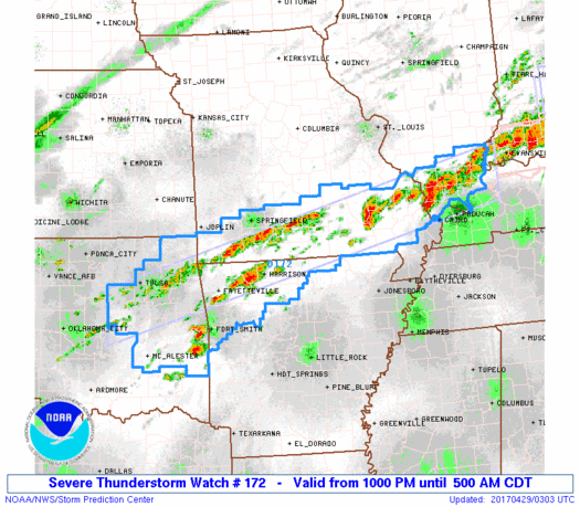
The NWS Storm Prediction Center has issued a * Severe Thunderstorm Watch for portions of Northwestern Arkansas Southern Illinois Southern Missouri Northeast and east central Oklahoma
* Effective this Friday night and Saturday morning from 1000 PM until 500 AM CDT.
* Primary threats include… Scattered large hail likely with isolated very large hail events to 2.5 inches in diameter possible Isolated damaging wind gusts to 70 mph possible A tornado or two possible
SUMMARY…Thunderstorms will gradually increase in coverage and intensity in a band from southern Illinois to southern Missouri/northwestern Arkansas and adjacent parts of eastern Oklahoma, and the storms will persist well into the overnight hours. Supercells will be possible within the broader area of convection, which will locally enhance the risk for large hail and damaging winds. Though most of the storms will be rooted slightly above the surface, and isolated tornado or two cannot be ruled out overnight.
The severe thunderstorm watch area is approximately along and 35 statute miles north and south of a line from 80 miles east of Carbondale IL to 60 miles southwest of Tulsa OK.
PRECAUTIONARY/PREPAREDNESS ACTIONS… REMEMBER…A Severe Thunderstorm Watch means conditions are favorable for severe thunderstorms in and close to the watch area. Persons in these areas should be on the lookout for threatening weather conditions and listen for later statements and possible warnings. Severe thunderstorms can and occasionally do produce tornadoes.
I will keep you updated as long as there is a severe threat for Franklin County.


Speak Your Mind
You must be logged in to post a comment.