Steve Dunford – franklincounty-news.com
Six days ago we had a long track tornado that started in Perryville MO, where the track ended on the west side of Franklin County. Intense rotation persisted all the way across the county until another tornado touch down in White County around the Crossville area and proceeded across the Wabash to and dissipated south of Oakland City, IN.
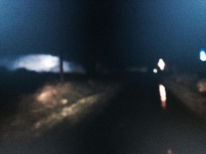
Dash cam still photo of the tornado that struck near Mulkeytown, retrieved from Franklin County EMA Director Ryan Buckingham’s on board vehicle camera system. Observing severe weather at night can be particularly difficult and dangerous due to low visibility and other environmental factors. (FCEMA photo)
The Perryville to Mulkeytown tornado had a 50.5 mile track. Since the National Weather Service office in Paducah was founded in 1984, it was the longest track tornado according to NWS meteorologist Robin Smith.
I had a half hour long conversation with Smith on Friday. I asked him a question about Tuesday night’s tornado. I told him that I have been a weather geek since I could barely talk. I said that storms seem to do weird things when the cross the Mississippi into Southern Illinois.
Here in Franklin County we are very fortunate of this but when the tornado was getting within a few miles of Rend Lake. it dissipated. The violent F-4 twister was approaching several population centers in the county, especially the city of Benton. I am not trivializing the ones that suffered loss around the Route 184/Yellowbanks area of the county, but the loss would have been beyond catastrophic if a large populated area was hit.
I asked Smith about bodies of water having effects on storms. I was caught up in the of the conversation to get a direct quote, but he said they do strange things. He mentioned that most of the time this particular tornado was on the ground in Southeast Missouri, there were multiple vorticies. After crossing the river into Southern Illinois, the storm became a single vortex.
Smith said if last Tuesday night’s storm would have stayed on the ground continuously through the rest of Franklin, Hamilton and White Counties it would have been about the same length of the Tri-State Tornado in 1925. The one that ended here in Franklin County ran a parallel track about 10 miles to the northwest of the Tri-State one.
The one that touched down around Crossville and went into Southern Indiana, was an identical track to the Tri-State tornado. In fact, one of the homes that was destroyed around Crossville, there was a home that was on the same property that was destroyed in 1925.
Tonight, we have a risk of severe weather in the overnight hours. The NWS and local media sources did an outstanding job relaying information to the public during this last event.
Since technology is in place to detect rotation, there are more Tornado Warnings issued. A lot of times when one it sighted on the ground it is too late. Rotation or funnel clouds should be taken as serious as a touchdown. If you are one who gets aggravated for break ins of your favorite program, just think if the tornado mentioned above was bearing down on you with no warning at all. I hope last Tuesday night was a wake up call if you feel that way.
The Paudcah Weather service office did a phenomenal job with the warning lead times. During the event we were under two PDS (Particularly Dangerous Situation) Tornado Watches and two PDS tornado warnings.
The Storm Prediction Center only gives three percent of tornado watches the PDS label. The Tornado warnings that are given that label are by the local weather service office. The last time there were warnings around here with that strong of language was the early morning of the Harrisburg tornado.
Tonight, we have a risk of severe weather in the overnight hours. The NWS and local media sources did an outstanding job relaying information to the public during this last event.
This event will be during the overnight hours. Just make sure you have a way to receive warnings and prepare in case there is an outage in your sleep.
I will post the second part of this in a couple of days. I am just going to share some observations that I see that will help you prepare for the next event.
It is Severe Weather Preparedness week here in Illinois. I will be sharing things from Franklin County Emergency Management Agency in regards to this.
One footnote I would like to share about last Tuesday night. Superintendent Richard Towers and the staff of Christopher Unit District #99 made a very good call having the players, cheerleaders and fans ride the storm out at Hamilton County High School after the sectional boys basketball game at Norris City. Thank you to the Hamco administration for opening their doors up.
I kept typing out warnings for this sites Facebook page and sending texts to my son that played on the Christopher basketball team. One of the greatest texts I ever received in my life was “Dad I am OK, I am in McLeansboro at the High School. We are staying here until the storm passes. Again, thank you all for your foresight that evening.


Speak Your Mind
You must be logged in to post a comment.