We are in the midst of a beautiful Saturday, with highs going to be in the 40’s. Tomorrow will be another gorgeous day with highs in the 50’s.
Here is where things begin to get dicey. On Monday the Storm Prediction center has Southern Illinois slated for a marginal risk for severe weather. Highs are supposed to be in the upper 50’s.
For Tuesday, they have Franklin County listed as a 15% chance of seeing a severe weather event. (See image above). When the Storm Prediction Center charts severe weather more than three days out, the confidence level is high.
Here is what Grant Dade, Chief Meteorologist from KFVS -TV had to say on social media about the upcoming severe weather on Tuesday. “As we have been saying for a few days, Tuesday has the
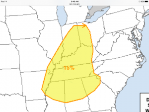
Probability of severe weather for Tuesday (NWS-SPC image)
potential to be an active day. The storm prediction center now has most of the Heartland under a severe thunderstorm risk. Still too early to know the low level features that would impact this event but all forms of severe weather seem possible at this time. We will continue to update.”
With a high in the mid 60’s forecasted for Tuesday, and a high in the upper 30’s on Wednesday, something is going to have to give. This is a situation that is worth keeping a close eye on things. We will continually keep you updated.
There is still a chance of snow showers for Thursday.


Speak Your Mind
You must be logged in to post a comment.