Good morning!
Here is your mid day forecast. Today it will be cloudy with a high in the upper 40’s. Rain chances return overnight, into tomorrow. We are supposed to have a beautiful Friday and Saturday, with highs in the 60’s., before rain returns on Saturday night into Sunday.
Here is the Hazardous weather outlook for the region:
THIS HAZARDOUS WEATHER OUTLOOK IS FOR PORTIONS OF SOUTHERN ILLINOIS, SOUTHWEST INDIANA, WESTERN KENTUCKY, AND SOUTHEAST MISSOURI.
.DAY ONE…TODAY AND TONIGHT A FEW RUMBLES OF THUNDER ARE POSSIBLE AFTER MIDNIGHT TONIGHT ACROSS SOUTHEAST MISSOURI, SOUTHERN ILLINOIS, AND WESTERN KENTUCKY. LIGHTNING WILL BE THE MAIN IMPACT.
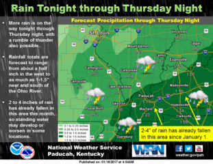
.DAYS TWO THROUGH SEVEN…THURSDAY THROUGH TUESDAY THERE IS A CHANCE FOR THUNDERSTORMS ACROSS MUCH OF THE AREA THURSDAY AND THURSDAY EVENING. LIGHTNING AND LOCALLY HEAVY RAINFALL WILL BE THE PRIMARY IMPACTS.
THE RAINFALL MAY BE STEADY AND PERSISTENT ENOUGH TO RESULT IN STANDING WATER IN SPOTS. THIS IS MOST LIKELY NEAR AND SOUTH OF THE OHIO RIVER WHERE THE HEAVIEST RAIN FELL WITH THE LAST EVENT AND IS FORECAST DURING THIS EVENT.
Here is a link to the full seven day forecast for Franklin County
http://forecast.weather.gov/MapClick.php?x=185&y=93&site=pah&zmx=&zmy=&map_x=185&map_y=93#.WH-QZdQrJxB


Speak Your Mind
You must be logged in to post a comment.