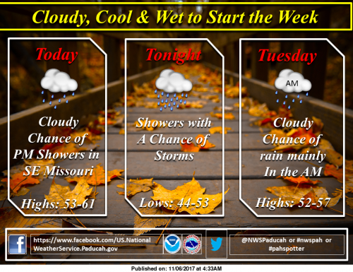
A pair of upper-level disturbances will bring precipitation to the region through Tuesday night. The first will bring showers and a few thunderstorms eastward across the region from late this afternoon through early Tuesday. The second will bring mainly light rain to the region Tuesday night. The sun will return Wednesday. In the meantime, clouds, rainfall and north winds will combine to make it feel quite cool, with high temperatures well below normal (NWS Paducah)
Hazardous Weather Outlook
This Hazardous Weather Outlook is for portions of southern
Illinois, southwest Indiana, western Kentucky, and southeast
Missouri.
.DAY ONE…Today and Tonight
Thunderstorms are possible this afternoon into this evening across
southeast Missouri, and portions of southern Illinois and west
Kentucky south of a line from Du Quoin Illinois, to Shawneetown,
to Calhoun Kentucky. Small hail will be possible with
thunderstorms, and a few thunderstorms may produce quarter size
hail or larger. Brief heavy rainfall and lightning will also be a
concern.
.DAYS TWO THROUGH SEVEN…Tuesday through Sunday
No hazardous weather is expected at this time.
.SPOTTER INFORMATION STATEMENT…
Spotter reports of hail or any other damage would be greatly
appreciated this afternoon and this evening.
Seven Day Forecast


Speak Your Mind
You must be logged in to post a comment.