Enjoy today…..a wet work week ahead….chances of mixed precip out of the forecast

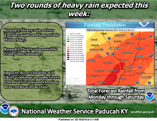
We’re closely following the threat of heavy rain coming up this week. At this time, the best chances for widespread heavy rainfall will be Tuesday night through Wednesday and again Friday into Saturday. If you have interests near area creeks and rivers, be sure to pay close attention to the latest forecasts. Keep up to date with the latest forecasts for your location at weather.gov/pah. (NWS-Paducah image)

Hydrologic Outlook

An unsettled weather pattern will result in potentially significant rainfall this week. Two periods of concern will be late Tuesday through Wednesday, then again late in the week. Several inches of rainfall are forecast. The anticipated heavy rainfall will be spread out over several days. This kind of scenario favors flooding of low land, poor drainage areas. It should also cause rises on area rivers and their tributaries.

The heaviest rainfall late Tuesday through Wednesday should be across southeast Missouri, southern Illinois and possibly southwest Indiana. By the end of the week, nearly all of the region including west Kentucky will experience heavy rainfall.

Stay up to date on the latest forecasts in the coming days for additional updates and forecasts.

Seven Day Forecast

Today
Mostly sunny, with a high near 53. South southeast wind 9 to 13 mph.
Tonight
Showers likely after midnight. Mostly cloudy, with a temperature rising to around 59 by 5am. South wind 8 to 16 mph, with gusts as high as 23 mph. Chance of precipitation is 70%.
Washington’s Birthday
Showers likely, mainly before noon. Cloudy, with a high near 69. Breezy, with a south wind 16 to 21 mph, with gusts as high as 38 mph. Chance of precipitation is 60%.
Monday Night
A 40 percent chance of showers. Cloudy, with a low around 62. South wind 15 to 17 mph, with gusts as high as 30 mph.
Tuesday
Showers likely, with thunderstorms also possible after noon. Cloudy, with a high near 73. Breezy, with a south wind 17 to 20 mph, with gusts as high as 33 mph. Chance of precipitation is 60%.
Tuesday Night
Showers before 9pm, then showers and possibly a thunderstorm between 9pm and 3am, then showers after 3am. Some of the storms could produce heavy rainfall. Low around 41. South wind 10 to 16 mph becoming north northwest after midnight. Winds could gust as high as 25 mph. Chance of precipitation is 100%.
Wednesday
Showers likely, mainly before noon. Cloudy, with a high near 44. North wind 9 to 11 mph. Chance of precipitation is 60%.
Wednesday Night
Showers likely, mainly before midnight. Cloudy, with a low around 33. North northeast wind 7 to 9 mph.
Thursday
Mostly cloudy, with a high near 48. North northeast wind around 8 mph.
Thursday Night
A chance of showers and thunderstorms, mainly after midnight. Mostly cloudy, with a low around 39. East wind around 7 mph.
Friday
Showers likely and possibly a thunderstorm. Cloudy, with a high near 52. East wind 6 to 9 mph becoming south in the afternoon.
Friday Night
Showers and possibly a thunderstorm. Cloudy, with a low around 47. South southwest wind 8 to 10 mph.
Saturday
A chance of showers and thunderstorms. Mostly cloudy, with a high near 59. Southwest wind 9 to 11 mph.
Print Friendly, PDF & Email

Speak Your Mind

Benton, West Frankfort, Illinois News | Franklin County News