Wind chill advisory remains in effect until noon tomorrow…..wintry mix in the forecast Sunday


…WIND CHILL ADVISORY REMAINS IN EFFECT UNTIL NOON CST TUESDAY…

A Wind Chill Advisory REMAINS IN EFFECT until noon CST Tuesday.

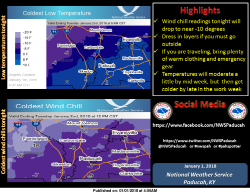
* WHAT…Lowest wind chill readings tonight will be near 10
below zero. The cold wind chills will cause frostbite on
exposed skin in as little as 30 minutes.

* WHERE…All of southern Illinois, southwest Indiana, western
Kentucky, and southeast Missouri.

* WHEN…Through noon Tuesday.

PRECAUTIONARY/PREPAREDNESS ACTIONS…

A Wind Chill Advisory means that cold air and the wind will
combine to create low wind chills. Frost bite and hypothermia can
occur if precautions are not taken. Make sure you wear a hat and
gloves.

Hazardous Weather Outlook

This Hazardous Weather Outlook is for portions of southern
Illinois, southwest Indiana, western Kentucky, and southeast
Missouri.

.DAY ONE…This Afternoon and Tonight

Wind chill readings tonight will drop to around 10 below zero.
Please see the wind chill advisory product for more details.

.DAYS TWO THROUGH SEVEN…Tuesday through Sunday

Wind chills early Tuesday will be near 10 below zero. Wind chill
readings will fall to between zero and 10 below late Wednesday
night into Thursday morning.

There is some potential for a wintry mix of precipitation to
develop on Sunday. The wintry precipitation could be enough to
produce hazardous conditions. It is too early to speculate on
precipitation amounts.

Seven Day Forecast

Tonight
Clear, with a low around -1. North northwest wind around 5 mph becoming calm in the evening.
Tuesday
Sunny, with a high near 19. Wind chill values as low as -1. Calm wind becoming west southwest around 6 mph in the afternoon.
Tuesday Night
Increasing clouds, with a low around 10. South southwest wind 3 to 7 mph.
Wednesday
Mostly sunny, with a high near 26. South southwest wind 7 to 11 mph becoming northwest in the afternoon.
Wednesday Night
Partly cloudy, with a low around 6. Northwest wind 8 to 13 mph.
Thursday
Sunny, with a high near 17. Northwest wind 7 to 9 mph.
Thursday Night
Partly cloudy, with a low around 5. North northwest wind 3 to 6 mph.
Friday
Mostly sunny, with a high near 20. North northwest wind 3 to 6 mph.
Friday Night
Mostly clear, with a low around 6. Northeast wind 3 to 5 mph.
Saturday
Mostly sunny, with a high near 27. East northeast wind around 6 mph becoming south southeast in the afternoon.
Saturday Night
Mostly cloudy, with a low around 19. South wind 6 to 8 mph.
Sunday
A chance of rain and snow. Mostly cloudy, with a high near 39. South wind 8 to 11 mph.
Sunday Night
Rain and snow likely. Cloudy, with a low around 31. South southwest wind 7 to 9 mph.
Monday
A chance of rain and snow. Mostly cloudy, with a high near 41. West southwest wind around 8 mph becoming northwest in the afternoon.


Speak Your Mind

Benton, West Frankfort, Illinois News | Franklin County News