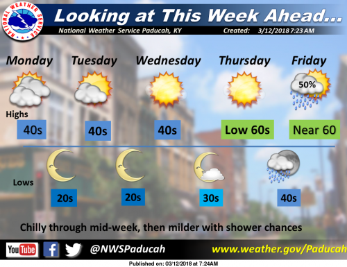
High pressure will move east across the lower Mississippi Valley Wednesday. As the high approaches, expect chilly northwest winds and gradually decreasing clouds early in the week. Once the high moves to our east, southwest winds will bring milder temperatures later in the week, along with a chance of showers. (NWS Paducah)
Today
Mostly cloudy, with a high near 42. Northwest wind 10 to 14 mph, with gusts as high as 20 mph.
Tonight
Partly cloudy, with a low around 27. North northwest wind 6 to 8 mph.
Tuesday
Partly sunny, with a high near 42. North northwest wind 7 to 14 mph, with gusts as high as 22 mph.
Tuesday Night
Partly cloudy, with a low around 25. Northwest wind 6 to 9 mph.
Wednesday
Sunny, with a high near 46. Northwest wind 5 to 9 mph.
Wednesday Night
Mostly clear, with a low around 34. Southwest wind 7 to 10 mph.
Thursday
Sunny, with a high near 61. Southwest wind around 9 mph.
Thursday Night
A chance of showers after 1am. Partly cloudy, with a low around 42. South southwest wind around 7 mph.
Friday
A chance of showers. Partly sunny, with a high near 58. East southeast wind 8 to 11 mph.
Friday Night
A chance of showers before 1am. Mostly cloudy, with a low around 46. East southeast wind around 9 mph.
Saturday
A chance of showers and thunderstorms. Partly sunny, with a high near 63. South wind around 9 mph.
Saturday Night
A chance of showers and thunderstorms. Mostly cloudy, with a low around 47. South wind around 7 mph.
Sunday
A chance of showers. Partly sunny, with a high near 65. South southwest wind 6 to 9 mph.


Speak Your Mind
You must be logged in to post a comment.