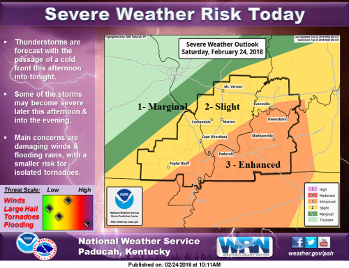
We’re continuing to monitor the potential for severe thunderstorms later this afternoon and evening. The primary concerns include damaging winds and flooding rains, with a smaller risk for a few tornadoes. Do you have a way to receive warning alerts and a plan of action to seek shelter in case severe weather threatens today? (NWS Paducah)
As long as the temperature remains in the low 50’s the chance of severe weather, especially tornadoes for this region lessens. The further south you go, or if you are south of the cold front, the tornado chance increases.
If the sun comes out and it warms up quickly into the 60’s is when we will be under the gun.
We will still be monitoring the situation. Follow the website’s Facebook page for info on the upcoming weather from area meteorologists.
Below are the statements issued by the National Weather Service.
Flood Warning for the Big Muddy
The National Weather Service in Paducah, Kentucky has issued a * Flood Warning for the Big Muddy River near Plumfield. * from late Sunday night to late Wednesday night.
* At 10:00 AM Saturday the stage was 17.9 feet. * Flood Stage is 20.0 feet. * Minor flooding is forecast.
* Forecast…Rise above flood stage by Monday morning and continue to rise to near 21.1 feet by Tuesday morning. * Impact…At 20.0 Feet…Minor flooding occurs affecting mainly bottom land and surrounding low lying area.
Flood Watch Until 6:00 a.m. Sunday
…FLOOD WATCH REMAINS IN EFFECT THROUGH LATE TONIGHT… The Flood Watch continues for * All of southeast Missouri, southern Illinois, southwest Indiana and western Kentucky. * Through late tonight.
* Showers and thunderstorms will be on the increase today, peaking in coverage and intensity later this afternoon and evening as a cold front approaches. With ground conditions already saturated, any additional rain from thunderstorms will only worsen existing areal flooding. Additionally, heavier rainfall rates from strong thunderstorms could easily produce dangerous flash flooding.
* Additional rains will aggravate already ongoing flooding of area rivers and tributaries across the region. Smaller streams and creeks not currently in flood will fill up and overspill their banks quickly, heightening the flood threat. In addition, elevated water levels in low lying and poor drainage areas, as well as waters that may not yet have receded from antecedent rainfall, may lead to more road closures due to high water crossings.
PRECAUTIONARY/PREPAREDNESS ACTIONS… A Flood Watch means there is a potential for flooding based on current forecasts. You should monitor later forecasts and be alert for possible Flood Warnings. Those living in areas prone to flooding should be prepared to take action should flooding develop. Heed all flood warning signs, and never cross a flooded roadway. Turn around and don`t drown! Remember it is harder to see rising waters at night. Seek high ground immediately if you encounter an area with rising waters.
Hazardous Weather Outlook
This Hazardous Weather Outlook is for portions of southern Illinois, southwest Indiana, western Kentucky, and southeast Missouri. .
DAY ONE…Today and Tonight There is a risk of severe thunderstorms this afternoon and evening. Damaging winds will be the main hazard. There is a risk of a few tornadoes as well. The areas with the highest probability for a tornado or two are southeast of a Cape Girardeau, Poplar Bluff Missouri line into far west Kentucky, mainly west of the Lakes, and the southern tip of Illinois.
Additional rainfall of up to 2 inches, with isolated higher amounts possible, will result in an additional flooding risk across the region today into tonight, especially across southeast Missouri into west Kentucky. A Flood Watch remains in effect through tonight for the entire region.
With stronger thunderstorm activity, Flash Flooding will be possible. Updates and details on continued river flooding can be referenced on the latest flood warnings and statements. .
DAYS TWO THROUGH SEVEN…Sunday through Friday Updates and details on continued river flooding can be referenced on the latest flood warnings and statements.
.SPOTTER INFORMATION STATEMENT… Spotter activation will be likely this afternoon and evening. Additional heavy rainfall and flooding reports are requested.
Seven Day Forecast


Speak Your Mind
You must be logged in to post a comment.