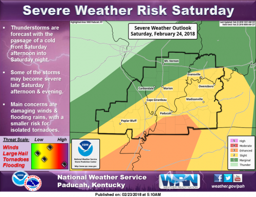
We’re continuing to monitor the potential for severe thunderstorms late Saturday afternoon and evening. The primary concerns include damaging winds and flooding rains, with a smaller risk for a few tornadoes. Do you have a way to receive warning alerts and a plan of action to seek shelter in case severe weather threatens this weekend? (NWS Paducah)
Hazardous Weather Outlook
A band of showers and a few thunderstorms will continue to produce moderate to heavy rainfall through at least midday as they stream over far southeast Missouri, much of west Kentucky and the southern tip of Illinois.
After a brief dry period this afternoon, more showers and thunderstorms will develop and lift northeast across the region tonight. Heavy rainfall and worsening flood problems can be expected. Please refer to the Flood Watch for details. Minor to moderate flooding continues or is imminent for the Ohio and Green Rivers, as well as parts of the Mississippi, Big Muddy, Patoka, and Wabash Rivers.
Please see the latest river flood warnings and statements for further details. .
DAYS TWO THROUGH SEVEN…Saturday through Thursday Widespread showers and thunderstorms with moderate to heavy rainfall are expected Saturday and Saturday night.
The Flood Watch continues until 6 AM Sunday. Please refer to the watch for details. The potential for severe thunderstorms with widespread damaging winds and a tornado threat exists late Saturday afternoon through the evening hours. The storms will most likely be in a line on or near a cold front that will move eastward across the region.
Minor to moderate flooding continues or is imminent for the Ohio and Green Rivers, as well as part of the Mississippi, Big Muddy, Patoka, and Wabash Rivers. Please see the latest river flood warnings and statements for further details. .
SPOTTER INFORMATION STATEMENT… Spotter activation is becoming more likely Saturday afternoon and evening. In addition, reports of heavy rainfall and flooding would be very helpful today through Saturday night.
…FLOOD WATCH REMAINS IN EFFECT THROUGH LATE SATURDAY NIGHT…
The Flood Watch continues for * All of southern Illinois, southwest Indiana, western Kentucky, and southeast Missouri. * Through late Saturday night.
* Periods of showers and thunderstorms will produce another 2 to 4 inches of rainfall through Saturday night. Isolated higher amounts will be possible. With saturated soil, the result will be worsening areal flood problems and the potential for flash flooding, especially Saturday afternoon and evening.
* The main flooding concern initially will be along small streams and creeks that feed into already swollen rivers across the region. Elsewhere, elevated water levels in low lying and poor drainage areas may lead to standing water across some roads that typically flood. However, a line of strong to severe thunderstorms Saturday afternoon and evening may result in more significant flash flooding over much of the region.
PRECAUTIONARY/PREPAREDNESS ACTIONS… A Flood Watch means there is a potential for flooding based on current forecasts. You should monitor later forecasts and be alert for possible Flood Warnings. Those living in areas prone to flooding should be prepared to take action should flooding develop.
Seven Day Forecast


Speak Your Mind
You must be logged in to post a comment.